Property Record
38389 State Highway 299 E, Burney, CA 96013
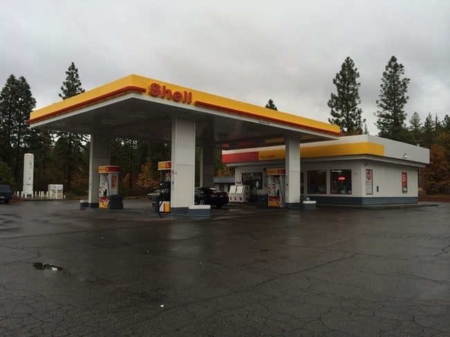


Property Detail
38389 State Highway 299 E
030-140-014-000
Shasta
Servicestationmarket
California
D Areas with possible but undetermined flood hazards.
50.57 AC
2024
California North Rural Area
2025
Other Market Areas
012701
Redding, CA
1,440 SF
NEARBY LISTINGS FOR SALE OR LEASE
-
-
View all Burney listings for sale on LoopNet.com
DEMOGRAPHICS near 38389 State Highway 299 E
1 mile
3 mile
5 mile
2025 Total Population
1,059
1,194
4,944
2030 Population
1,135
1,266
5,064
Pop Growth 2025-2030
+ 7.18%
+ 6.03%
+ 2.43%
Average Age
45
45
44
2025 Total Households
465
527
2,107
HH Growth 2025-2030
+ 7.10%
+ 5.88%
+ 2.37%
Median Household Inc
$43,831
$44,334
$57,269
Avg Household Size
2.20
2.20
2.20
2025 Avg HH Vehicles
2.00
2.00
2.00
Median Home Value
$232,727
$237,395
$250,554
Median Year Built
1968
1970
1974
Nearby Places
Map Layers
Map Styles
 Street
 Aerial
Layers
 Traffic
 Biking
Places
Listings with unknown addresses are not visible on the map
- Restaurants
- Banks
- Shops
- Fitness
- Groceries
SALE & LEASE HISTORY
LISTING DATE
SALE/LEASE

Sep 24, 2016
For Sale
Aug 18, 2025
For Sale
Nearby Properties
Address
Land Use
TOTAL SIZE
Lot Size
Zoning
Address
Land Use
TOTAL SIZE
Lot Size
Zoning
18,985 SF
2.01 AC
C-2-DR
Address
Land Use
TOTAL SIZE
Lot Size
Zoning
288.22 AC
MR
Address
Land Use
TOTAL SIZE
Lot Size
Zoning
10,600 SF
0.34 AC
C-O
Address
Land Use
TOTAL SIZE
Lot Size
Zoning
17,500 SF
0.98 AC
C-2
Address
Land Use
TOTAL SIZE
Lot Size
Zoning
174.40 AC
EA-AP
Address
Land Use
TOTAL SIZE
Lot Size
Zoning
0.16 AC
PF
Address
Land Use
TOTAL SIZE
Lot Size
Zoning
320 AC
U
Address
Land Use
TOTAL SIZE
Lot Size
Zoning
4,860 SF
1.03 AC
C-2
Address
Land Use
TOTAL SIZE
Lot Size
Zoning
110.47 AC
U-MRB
Address
Land Use
TOTAL SIZE
Lot Size
Zoning
1.38 AC
C-2
Address
Land Use
TOTAL SIZE
Lot Size
Zoning
2,315 SF
6.45 AC
R-L
Address
Land Use
TOTAL SIZE
Lot Size
Zoning
5,000 SF
20 AC
UMRB
Address
Land Use
TOTAL SIZE
Lot Size
Zoning
0.83 AC
C-2
Address
Land Use
TOTAL SIZE
Lot Size
Zoning
3,310 SF
0.55 AC
IR
Address
Land Use
TOTAL SIZE
Lot Size
Zoning
2,400 SF
1.50 AC
PD
Address
Land Use
TOTAL SIZE
Lot Size
Zoning
2,856 SF
2 AC
IR
Address
Land Use
TOTAL SIZE
Lot Size
Zoning
12,600 SF
1.16 AC
C-2
Address
Land Use
TOTAL SIZE
Lot Size
Zoning
1,832 SF
0.26 AC
C-O
Address
Land Use
TOTAL SIZE
Lot Size
Zoning
1.10 AC
C-M
Address
Land Use
TOTAL SIZE
Lot Size
Zoning
2.79 AC
MHP
Address
Land Use
TOTAL SIZE
Lot Size
Zoning
1,920 SF
1.89 AC
C-M
Address
Land Use
TOTAL SIZE
Lot Size
Zoning
1,456 SF
0.24 AC
IR
Address
Land Use
TOTAL SIZE
Lot Size
Zoning
0.65 AC
C-2
Address
Land Use
TOTAL SIZE
Lot Size
Zoning
5 AC
M-L-DR
Address
Land Use
TOTAL SIZE
Lot Size
Zoning
1,560 SF
1 AC
C-2
Address
Land Use
TOTAL SIZE
Lot Size
Zoning
1,600 SF
0.69 AC
C-2
The World's #1 Commercial Real Estate Marketplace
Connect with us
© 2026 CoStar Group
The information above has been obtained from sources believed reliable. While we do not doubt its accuracy we have not verified it and make no guarantee, warranty or representation about it. It is your responsibility to independently confirm its accuracy and completeness. Any projections, opinions, assumptions, or estimates used are for example only and do not represent the current or future performance of the property. The value of this transaction to you depends on tax and other factors which should be evaluated by your tax, financial, and legal advisors. You and your advisors should conduct a careful, independent investigation of the property to determine to your satisfaction the suitability of the property for your needs.