Property Record
3839 50Th St, Lubbock, TX 79413
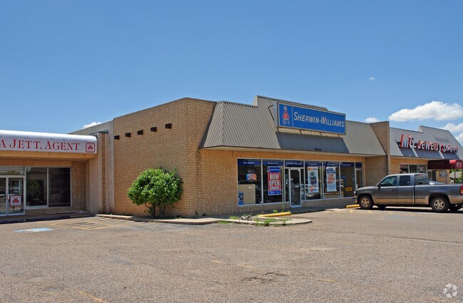

Property Detail
3839 50Th St
Lubbock, TX
FIRST FEDERAL E49.83OF W161 OF TR B
R93981
Lubbock
Stripcommercialcenter
Texas
B and X Area of moderate flood hazard, usually the area between the limits of the 100-year and 500-year floods.
2
2024
0.33 AC
2025
Southwest Inner Loop
001907
Lubbock
6,100 SF
NEARBY LISTINGS FOR SALE OR LEASE
DEMOGRAPHICS near 3839 50Th St
1 mile
3 mile
5 mile
2024 Total Population
14,587
118,574
243,735
2029 Population
15,061
122,653
253,760
Pop Growth 2024-2029
+ 3.25%
+ 3.44%
+ 4.11%
Average Age
37
36
36
2024 Total Households
5,857
47,138
96,525
HH Growth 2024-2029
+ 3.53%
+ 4.03%
+ 4.53%
Median Household Inc
$64,719
$54,473
$55,834
Avg Household Size
2.40
2.30
2.40
2024 Avg HH Vehicles
2.00
2.00
2.00
Median Home Value
$191,729
$203,578
$212,595
Median Year Built
1967
1973
1985
Nearby Places
Map Layers
Map Styles
 Street
 Aerial
Transit
 Traffic
 Biking
Places
Listings with unknown addresses are not visible on the map
- Restaurants
- Banks
- Shops
- Fitness
- Groceries
PUBLIC TRANSPORTATION
AIRPORT
Lubbock Preston Smith International
Drive
Walk
Distance
Lubbock Preston Smith International
30 min
16.1 mi
Nearby Properties
Address
Land Use
TOTAL SIZE
Lot Size
Zoning
Address
Land Use
TOTAL SIZE
Lot Size
Zoning
791,096 SF
63.76 AC
Address
Land Use
TOTAL SIZE
Lot Size
Zoning
391,942 SF
17.89 AC
Address
Land Use
TOTAL SIZE
Lot Size
Zoning
106,894 SF
5.83 AC
Address
Land Use
TOTAL SIZE
Lot Size
Zoning
176,165 SF
36.61 AC
Address
Land Use
TOTAL SIZE
Lot Size
Zoning
64,800 SF
0.94 AC
Address
Land Use
TOTAL SIZE
Lot Size
Zoning
153,416 SF
3.14 AC
Address
Land Use
TOTAL SIZE
Lot Size
Zoning
289,796 SF
14.67 AC
Address
Land Use
TOTAL SIZE
Lot Size
Zoning
247,870 SF
11.48 AC
Address
Land Use
TOTAL SIZE
Lot Size
Zoning
219,352 SF
21.90 AC
Address
Land Use
TOTAL SIZE
Lot Size
Zoning
143,905 SF
0.28 AC
Address
Land Use
TOTAL SIZE
Lot Size
Zoning
156,495 SF
15.85 AC
Address
Land Use
TOTAL SIZE
Lot Size
Zoning
138,202 SF
11.33 AC
Address
Land Use
TOTAL SIZE
Lot Size
Zoning
79,733 SF
3.14 AC
Address
Land Use
TOTAL SIZE
Lot Size
Zoning
172,627 SF
8.12 AC
Address
Land Use
TOTAL SIZE
Lot Size
Zoning
199,854 SF
19.21 AC
Address
Land Use
TOTAL SIZE
Lot Size
Zoning
220,236 SF
13.42 AC
Address
Land Use
TOTAL SIZE
Lot Size
Zoning
198,209 SF
9.98 AC
Address
Land Use
TOTAL SIZE
Lot Size
Zoning
75,154 SF
6.95 AC
Address
Land Use
TOTAL SIZE
Lot Size
Zoning
128,355 SF
8.91 AC
Address
Land Use
TOTAL SIZE
Lot Size
Zoning
139,085 SF
17.53 AC
Address
Land Use
TOTAL SIZE
Lot Size
Zoning
128,198 SF
9.88 AC
Address
Land Use
TOTAL SIZE
Lot Size
Zoning
52,020 SF
0.86 AC
Address
Land Use
TOTAL SIZE
Lot Size
Zoning
177,154 SF
8.79 AC
Address
Land Use
TOTAL SIZE
Lot Size
Zoning
164,196 SF
8.48 AC
Address
Land Use
TOTAL SIZE
Lot Size
Zoning
77,553 SF
9.63 AC
Address
Land Use
TOTAL SIZE
Lot Size
Zoning
40,258 SF
0.99 AC
Address
Land Use
TOTAL SIZE
Lot Size
Zoning
81,688 SF
2 AC
Address
Land Use
TOTAL SIZE
Lot Size
Zoning
83,300 SF
2.07 AC
Address
Land Use
TOTAL SIZE
Lot Size
Zoning
175,958 SF
8.13 AC
Address
Land Use
TOTAL SIZE
Lot Size
Zoning
88,998 SF
7.56 AC
The World's #1 Commercial Real Estate Marketplace
Connect with us
© 2026 CoStar Group
The information above has been obtained from sources believed reliable. While we do not doubt its accuracy we have not verified it and make no guarantee, warranty or representation about it. It is your responsibility to independently confirm its accuracy and completeness. Any projections, opinions, assumptions, or estimates used are for example only and do not represent the current or future performance of the property. The value of this transaction to you depends on tax and other factors which should be evaluated by your tax, financial, and legal advisors. You and your advisors should conduct a careful, independent investigation of the property to determine to your satisfaction the suitability of the property for your needs.