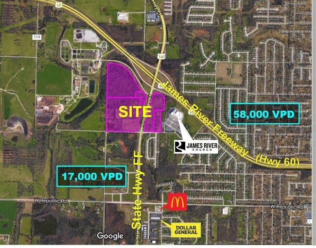
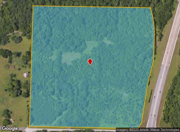
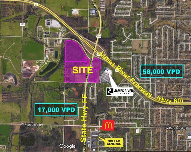
Property Record
3839 S State Highway Ff, Springfield, MO 65807
NEARBY LISTINGS FOR SALE OR LEASE
Property Detail
3839 S State Highway Ff
18-08-200-009
38.93A M/L SW1/4 NW1/4 8/28/22 (EX HWY) & (EX PT DEEDED FOR NEW R/W)
Livestock
Greene
X
Missouri
29077C0338E
37.93 AC
2025
Outlying Greene County
2025
Springfield
001401
Springfield, MO
1,211 SF
DEMOGRAPHICS near 3839 S State Highway Ff
1 Mile
3 Mile
5 Mile
2024 Total Population
4,481
40,511
107,598
2029 Population
4,643
41,734
111,652
Pop Growth 2024-2029
+ 3.62%
+ 3.02%
+ 3.77%
Average Age
39
40
39
2024 Total Households
1,795
16,543
46,092
HH Growth 2024-2029
+ 3.68%
+ 3.11%
+ 4.01%
Median Household Inc
$67,148
$66,189
$55,060
Avg Household Size
2.50
2.40
2.20
2024 Avg HH Vehicles
2.00
2.00
2.00
Median Home Value
$201,068
$194,163
$175,215
Median Year Built
1996
1995
1991
Nearby Places
Map Layers
Map Styles
 Street
 Aerial
- Restaurants
- Banks
- Shops
- Fitness
- Groceries
PUBLIC TRANSPORTATION
AIRPORT
Springfield-Branson Ntl
DRIVE
WALK
Distance
Springfield-Branson Ntl
24 min
10.8 mi
SALE & LEASE HISTORY
LISTING DATE
SALE/LEASE

Jul 31, 2017
For Lease
Jul 28, 2017
For Lease
Nearby Properties
Address
Land Use
TOTAL SIZE
Lot Size
Zoning
Address
Land Use
TOTAL SIZE
Lot Size
Zoning
18.52 AC
INC
Address
Land Use
TOTAL SIZE
Lot Size
Zoning
22.64 AC
INC
Address
Land Use
TOTAL SIZE
Lot Size
Zoning
Address
Land Use
TOTAL SIZE
Lot Size
Zoning
312,092 SF
38 AC
INC
Address
Land Use
TOTAL SIZE
Lot Size
Zoning
614,588 SF
57.27 AC
INC
Address
Land Use
TOTAL SIZE
Lot Size
Zoning
Address
Land Use
TOTAL SIZE
Lot Size
Zoning
129,652 SF
16.40 AC
INC
Address
Land Use
TOTAL SIZE
Lot Size
Zoning
334,594 SF
17.75 AC
INC
Address
Land Use
TOTAL SIZE
Lot Size
Zoning
9.82 AC
INC
Address
Land Use
TOTAL SIZE
Lot Size
Zoning
159,007 SF
16.05 AC
INC
Address
Land Use
TOTAL SIZE
Lot Size
Zoning
30,400 SF
9.05 AC
INC
Address
Land Use
TOTAL SIZE
Lot Size
Zoning
6.24 AC
INC
Address
Land Use
TOTAL SIZE
Lot Size
Zoning
12.81 AC
INC
Address
Land Use
TOTAL SIZE
Lot Size
Zoning
157,773 SF
18.55 AC
INC
Address
Land Use
TOTAL SIZE
Lot Size
Zoning
16.39 AC
INC
Address
Land Use
TOTAL SIZE
Lot Size
Zoning
8.26 AC
INC
Address
Land Use
TOTAL SIZE
Lot Size
Zoning
Address
Land Use
TOTAL SIZE
Lot Size
Zoning
10.58 AC
INC
Address
Land Use
TOTAL SIZE
Lot Size
Zoning
47,500 SF
5.24 AC
INC
Address
Land Use
TOTAL SIZE
Lot Size
Zoning
117,757 SF
6.50 AC
INC
Address
Land Use
TOTAL SIZE
Lot Size
Zoning
137,716 SF
11.08 AC
INC
Address
Land Use
TOTAL SIZE
Lot Size
Zoning
43,884 SF
2.42 AC
INC
Address
Land Use
TOTAL SIZE
Lot Size
Zoning
115,212 SF
6.70 AC
INC
Address
Land Use
TOTAL SIZE
Lot Size
Zoning
126,242 SF
4.75 AC
INC
Address
Land Use
TOTAL SIZE
Lot Size
Zoning
85,030 SF
8.89 AC
INC
Address
Land Use
TOTAL SIZE
Lot Size
Zoning
128,448 SF
4.30 AC
INC
Address
Land Use
TOTAL SIZE
Lot Size
Zoning
113,712 SF
11.10 AC
INC
Address
Land Use
TOTAL SIZE
Lot Size
Zoning
5.63 AC
INC
Address
Land Use
TOTAL SIZE
Lot Size
Zoning
6.65 AC
INC
Address
Land Use
TOTAL SIZE
Lot Size
Zoning
132,065 SF
8 AC
INC
The World's #1 Commercial Real Estate Marketplace
Connect with us
© 2026 CoStar Group
The information above has been obtained from sources believed reliable. While we do not doubt its accuracy we have not verified it and make no guarantee, warranty or representation about it. It is your responsibility to independently confirm its accuracy and completeness. Any projections, opinions, assumptions, or estimates used are for example only and do not represent the current or future performance of the property. The value of this transaction to you depends on tax and other factors which should be evaluated by your tax, financial, and legal advisors. You and your advisors should conduct a careful, independent investigation of the property to determine to your satisfaction the suitability of the property for your needs.