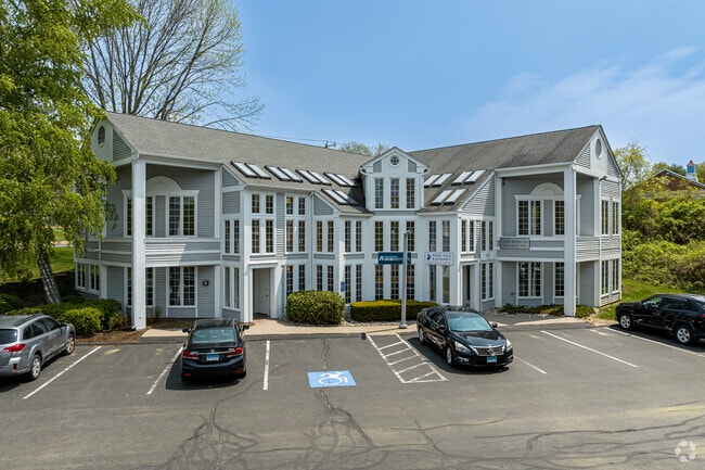
Property Record
384 Merrow Rd, Tolland, CT 06084

Save to a Folder
{{folder.Name}}
{{folder.ListingIds.length}} Properties
{{folder.ListingIds.length}} Property
Create a New Folder
Property Detail
384 Merrow Rd
Hartford-West Hartford-East Hartford, CT
Capitol
TOLL-000029-M000000-000003
Connecticut
Commercialnec
3-0
TCZ
9.05 AC
2025
Tolland County
2025
Hartford
533102
NEARBY LISTINGS FOR SALE OR LEASE
DEMOGRAPHICS near 384 Merrow Rd
1 mile
3 mile
5 mile
2025 Total Population
1,561
10,694
29,863
2030 Population
1,580
10,898
30,530
Pop Growth 2025-2030
+ 1.22%
+ 1.91%
+ 2.23%
Average Age
42
42
40
2025 Total Households
603
4,129
11,197
HH Growth 2025-2030
+ 1.16%
+ 1.94%
+ 2.35%
Median Household Inc
$108,386
$113,902
$107,155
Avg Household Size
2.60
2.60
2.50
2025 Avg HH Vehicles
2.00
2.00
2.00
Median Home Value
$310,484
$348,044
$352,447
Median Year Built
1976
1978
1978
Nearby Places
Map Layers
Map Styles
 Street
 Aerial
Layers
 Traffic
 Biking
Places
Listings with unknown addresses are not visible on the map
- Restaurants
- Banks
- Shops
- Fitness
- Groceries
PUBLIC TRANSPORTATION
AIRPORT
Bradley International
Drive
Walk
Distance
Bradley International
44 min
30.2 mi
Worcester Regional
Drive
Walk
Distance
Worcester Regional
65 min
46.1 mi
Freight Ports
Port of New Haven
Drive
Walk
Distance
Port of New Haven
74 min
57.3 mi
SALE & LEASE HISTORY
LISTING DATE
SALE/LEASE

Sep 25, 2016
For Lease
Sep 20, 2023
For Sale
May 03, 2022
For Sale
Jul 10, 2025
For Lease
Jul 10, 2025
For Lease
Feb 22, 2021
For Lease
Aug 29, 2025
For Lease
Apr 10, 2019
For Lease
Nearby Properties
Address
Land Use
TOTAL SIZE
Lot Size
Zoning
Address
Land Use
TOTAL SIZE
Lot Size
Zoning
258,330 SF
68.50 AC
RDD
Address
Land Use
TOTAL SIZE
Lot Size
Zoning
168,410 SF
100.15 AC
RDD
Address
Land Use
TOTAL SIZE
Lot Size
Zoning
46.42 AC
VCZ
Address
Land Use
TOTAL SIZE
Lot Size
Zoning
20.50 AC
GDD
Address
Land Use
TOTAL SIZE
Lot Size
Zoning
48 AC
RDD
Address
Land Use
TOTAL SIZE
Lot Size
Zoning
63,016 SF
8.60 AC
R80
Address
Land Use
TOTAL SIZE
Lot Size
Zoning
113,904 SF
38.80 AC
R80
Address
Land Use
TOTAL SIZE
Lot Size
Zoning
59.01 AC
RDD
Address
Land Use
TOTAL SIZE
Lot Size
Zoning
61,155 SF
34 AC
R80
Address
Land Use
TOTAL SIZE
Lot Size
Zoning
10 AC
RDD
Address
Land Use
TOTAL SIZE
Lot Size
Zoning
33,328 SF
17.48 AC
R80
Address
Land Use
TOTAL SIZE
Lot Size
Zoning
38,054 SF
35.50 AC
R80
Address
Land Use
TOTAL SIZE
Lot Size
Zoning
50.71 AC
GDD
Address
Land Use
TOTAL SIZE
Lot Size
Zoning
26,602 SF
5.47 AC
VCZ
Address
Land Use
TOTAL SIZE
Lot Size
Zoning
27,740 SF
11.92 AC
RDD
Address
Land Use
TOTAL SIZE
Lot Size
Zoning
16,414 SF
3.44 AC
GDD
Address
Land Use
TOTAL SIZE
Lot Size
Zoning
10,728 SF
39.68 AC
RDD
Address
Land Use
TOTAL SIZE
Lot Size
Zoning
37,556 SF
7.91 AC
GDD
Address
Land Use
TOTAL SIZE
Lot Size
Zoning
1,200 SF
108 AC
RDD
Address
Land Use
TOTAL SIZE
Lot Size
Zoning
1.99 AC
VCZ
Address
Land Use
TOTAL SIZE
Lot Size
Zoning
1,132 SF
0.78 AC
RDD
Address
Land Use
TOTAL SIZE
Lot Size
Zoning
32,583 SF
16.71 AC
DC
Address
Land Use
TOTAL SIZE
Lot Size
Zoning
44,000 SF
5 AC
DI
Address
Land Use
TOTAL SIZE
Lot Size
Zoning
15.32 AC
TCZ
Address
Land Use
TOTAL SIZE
Lot Size
Zoning
16,128 SF
4.91 AC
TCZ
Address
Land Use
TOTAL SIZE
Lot Size
Zoning
6,806 SF
131.13 AC
RDD
Address
Land Use
TOTAL SIZE
Lot Size
Zoning
2,176 SF
15.90 AC
RAR90
Address
Land Use
TOTAL SIZE
Lot Size
Zoning
3.42 AC
VCZ
Address
Land Use
TOTAL SIZE
Lot Size
Zoning
9,259 SF
2.24 AC
NCZG
The World's #1 Commercial Real Estate Marketplace
Connect with us
© 2026 CoStar Group
The information above has been obtained from sources believed reliable. While we do not doubt its accuracy we have not verified it and make no guarantee, warranty or representation about it. It is your responsibility to independently confirm its accuracy and completeness. Any projections, opinions, assumptions, or estimates used are for example only and do not represent the current or future performance of the property. The value of this transaction to you depends on tax and other factors which should be evaluated by your tax, financial, and legal advisors. You and your advisors should conduct a careful, independent investigation of the property to determine to your satisfaction the suitability of the property for your needs.