Property Record
384 Shoemaker Ln, Agawam, MA 01001
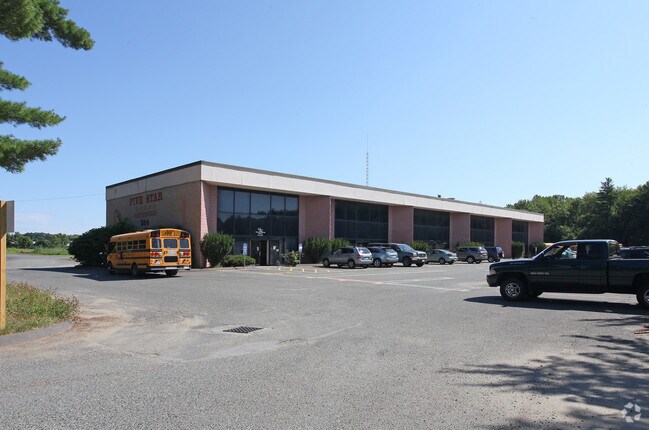

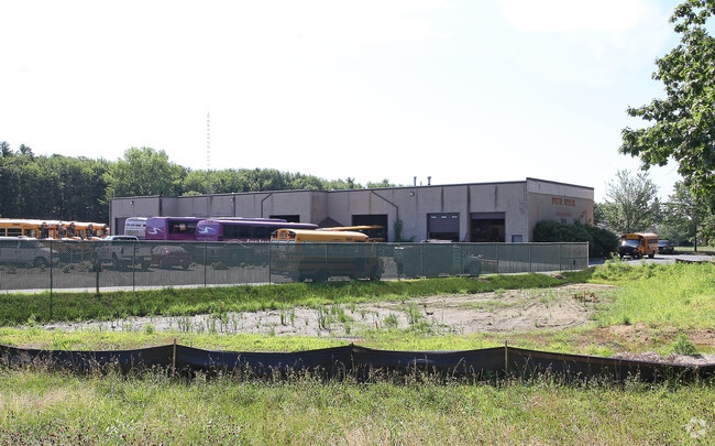
Property Detail
384 Shoemaker Ln
AGAW-000004G-000002-000002
Hampden
Publicschool
Massachusetts
IB
2
B and X Area of moderate flood hazard, usually the area between the limits of the 100-year and 500-year floods.
5.07 AC
0
Hampden County
2025
Hartford
813205
Springfield, MA
13,439 SF
NEARBY LISTINGS FOR SALE OR LEASE
DEMOGRAPHICS near 384 Shoemaker Ln
1 mile
3 mile
5 mile
2025 Total Population
647
23,424
91,679
2030 Population
643
23,394
92,002
Pop Growth 2025-2030
(0.62%)
(0.13%)
+ 0.35%
Average Age
46
44
42
2025 Total Households
277
9,359
36,227
HH Growth 2025-2030
(0.72%)
(0.27%)
+ 0.31%
Median Household Inc
$72,749
$88,560
$82,982
Avg Household Size
2.30
2.40
2.40
2025 Avg HH Vehicles
2.00
2.00
2.00
Median Home Value
$334,694
$334,923
$333,574
Median Year Built
1974
1968
1959
Nearby Places
Map Layers
Map Styles
 Street
 Aerial
Layers
 Traffic
 Biking
Places
Listings with unknown addresses are not visible on the map
- Restaurants
- Banks
- Shops
- Fitness
- Groceries
PUBLIC TRANSPORTATION
COMMUTER RAIL
Drive
Walk
Distance
13 min
6.8 mi
AIRPORT
Bradley International
Drive
Walk
Distance
Bradley International
21 min
9.1 mi
Nearby Properties
Address
Land Use
TOTAL SIZE
Lot Size
Zoning
Address
Land Use
TOTAL SIZE
Lot Size
Zoning
36.53 AC
IB
Address
Land Use
TOTAL SIZE
Lot Size
Zoning
236,032 SF
41.65 AC
RA2
Address
Land Use
TOTAL SIZE
Lot Size
Zoning
1,840 SF
148.78 AC
BB
Address
Land Use
TOTAL SIZE
Lot Size
Zoning
133,822 SF
40.51 AC
RA2
Address
Land Use
TOTAL SIZE
Lot Size
Zoning
2,022 SF
33.70 AC
AG
Address
Land Use
TOTAL SIZE
Lot Size
Zoning
18.51 AC
BA
Address
Land Use
TOTAL SIZE
Lot Size
Zoning
241,663 SF
13.59 AC
IA
Address
Land Use
TOTAL SIZE
Lot Size
Zoning
78,732 SF
16.72 AC
BA
Address
Land Use
TOTAL SIZE
Lot Size
Zoning
73,356 SF
18.20 AC
RA2
Address
Land Use
TOTAL SIZE
Lot Size
Zoning
205,380 SF
15.41 AC
IA
Address
Land Use
TOTAL SIZE
Lot Size
Zoning
186,125 SF
14.69 AC
IA
Address
Land Use
TOTAL SIZE
Lot Size
Zoning
6.73 AC
BA
Address
Land Use
TOTAL SIZE
Lot Size
Zoning
125,000 SF
15.35 AC
IA
Address
Land Use
TOTAL SIZE
Lot Size
Zoning
67,046 SF
11.63 AC
BA
Address
Land Use
TOTAL SIZE
Lot Size
Zoning
12.26 AC
IB
Address
Land Use
TOTAL SIZE
Lot Size
Zoning
68,644 SF
5.20 AC
RA2
Address
Land Use
TOTAL SIZE
Lot Size
Zoning
43,582 SF
4.39 AC
BA
Address
Land Use
TOTAL SIZE
Lot Size
Zoning
62,471 SF
28.11 AC
RA2
Address
Land Use
TOTAL SIZE
Lot Size
Zoning
9.50 AC
RA2
Address
Land Use
TOTAL SIZE
Lot Size
Zoning
67,432 SF
12.60 AC
RA2
Address
Land Use
TOTAL SIZE
Lot Size
Zoning
146,211 SF
11.72 AC
IA
Address
Land Use
TOTAL SIZE
Lot Size
Zoning
8.85 AC
RA2
Address
Land Use
TOTAL SIZE
Lot Size
Zoning
69,430 SF
10.30 AC
IB
Address
Land Use
TOTAL SIZE
Lot Size
Zoning
48,448 SF
50.40 AC
AG
Address
Land Use
TOTAL SIZE
Lot Size
Zoning
4,615 SF
4.59 AC
BA
Address
Land Use
TOTAL SIZE
Lot Size
Zoning
93,875 SF
13.49 AC
IA
Address
Land Use
TOTAL SIZE
Lot Size
Zoning
51,898 SF
6.88 AC
IB
Address
Land Use
TOTAL SIZE
Lot Size
Zoning
1.69 AC
BA
Address
Land Use
TOTAL SIZE
Lot Size
Zoning
41,182 SF
11.20 AC
BA
Address
Land Use
TOTAL SIZE
Lot Size
Zoning
66,443 SF
39.75 AC
BA
The World's #1 Commercial Real Estate Marketplace
Connect with us
© 2026 CoStar Group
The information above has been obtained from sources believed reliable. While we do not doubt its accuracy we have not verified it and make no guarantee, warranty or representation about it. It is your responsibility to independently confirm its accuracy and completeness. Any projections, opinions, assumptions, or estimates used are for example only and do not represent the current or future performance of the property. The value of this transaction to you depends on tax and other factors which should be evaluated by your tax, financial, and legal advisors. You and your advisors should conduct a careful, independent investigation of the property to determine to your satisfaction the suitability of the property for your needs.