Property Record
3840 W Highway 27, Lincolnton, NC 28092

NEARBY LISTINGS FOR SALE OR LEASE
-
-
View all Lincolnton listings for sale on LoopNet.com
Property Detail
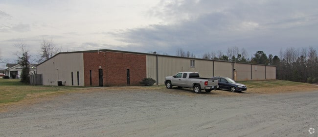
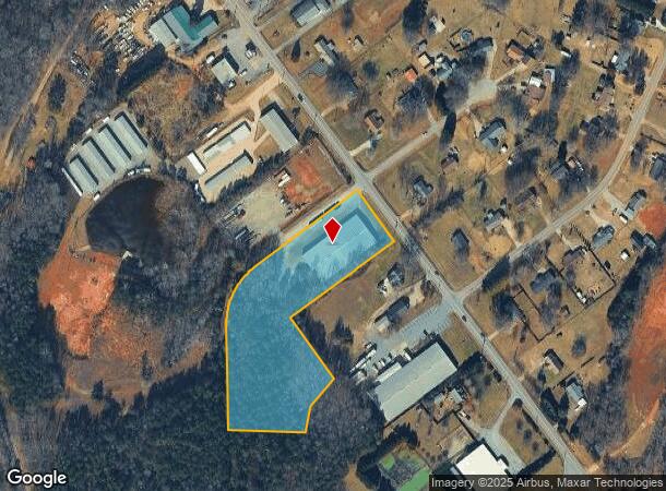
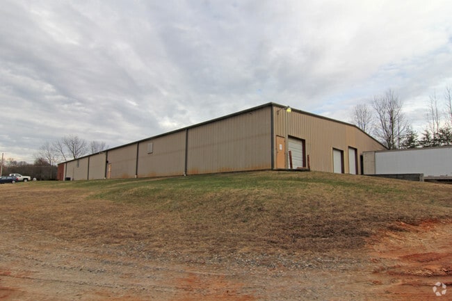
3840 W Highway 27
Charlotte-Concord-Gastonia, NC-SC
HWY 27
01729
Lincoln
Warehouse
North Carolina
2025
3.86 AC
2025
Lincoln County
070201
Charlotte
20,000 SF
DEMOGRAPHICS near 3840 W Highway 27
1 Mile
3 Mile
5 Mile
2024 Total Population
1,092
11,573
32,789
2029 Population
1,263
13,425
38,024
Pop Growth 2024-2029
+ 15.66%
+ 16.00%
+ 15.97%
Average Age
43
43
42
2024 Total Households
432
4,595
13,195
HH Growth 2024-2029
+ 15.97%
+ 16.34%
+ 16.32%
Median Household Inc
$59,177
$67,354
$62,494
Avg Household Size
2.50
2.40
2.40
2024 Avg HH Vehicles
2.00
2.00
2.00
Median Home Value
$160,431
$196,038
$193,854
Median Year Built
1986
1986
1986
Nearby Places
Map Layers
Map Styles
 Street
 Aerial
- Restaurants
- Banks
- Shops
- Fitness
- Groceries
PUBLIC TRANSPORTATION
AIRPORT
Charlotte/Douglas International
DRIVE
WALK
Distance
Charlotte/Douglas International
48 min
25.8 mi
Concord-Padgett Regional
DRIVE
WALK
Distance
Concord-Padgett Regional
51 min
36.3 mi
Nearby Properties
Address
Land Use
TOTAL SIZE
Lot Size
Zoning
Address
Land Use
TOTAL SIZE
Lot Size
Zoning
172,724 SF
55.65 AC
O-I CU
Address
Land Use
TOTAL SIZE
Lot Size
Zoning
29,244 SF
15.15 AC
R-O CU
Address
Land Use
TOTAL SIZE
Lot Size
Zoning
393,708 SF
270.27 AC
I-G & R-SF
Address
Land Use
TOTAL SIZE
Lot Size
Zoning
80,509 SF
16.23 AC
P-B CU
Address
Land Use
TOTAL SIZE
Lot Size
Zoning
36,448 SF
7.73 AC
RMF
Address
Land Use
TOTAL SIZE
Lot Size
Zoning
53,917 SF
20.36 AC
R-T
Address
Land Use
TOTAL SIZE
Lot Size
Zoning
11,248 SF
5.23 AC
G-B & R-8
Address
Land Use
TOTAL SIZE
Lot Size
Zoning
9,184 SF
30.79 AC
R-S
Address
Land Use
TOTAL SIZE
Lot Size
Zoning
22,870 SF
10.60 AC
R-O
Address
Land Use
TOTAL SIZE
Lot Size
Zoning
52,730 SF
5.85 AC
G-B
Address
Land Use
TOTAL SIZE
Lot Size
Zoning
8,936 SF
9.04 AC
R-T
Address
Land Use
TOTAL SIZE
Lot Size
Zoning
10,630 SF
3.21 AC
R-8 & R-25
Address
Land Use
TOTAL SIZE
Lot Size
Zoning
41,988 SF
5.22 AC
GMC
Address
Land Use
TOTAL SIZE
Lot Size
Zoning
17,020 SF
3.98 AC
R-25
Address
Land Use
TOTAL SIZE
Lot Size
Zoning
35,860 SF
2.05 AC
G-B
Address
Land Use
TOTAL SIZE
Lot Size
Zoning
9,980 SF
21.79 AC
R-S
Address
Land Use
TOTAL SIZE
Lot Size
Zoning
14,848 SF
4.83 AC
R-15
Address
Land Use
TOTAL SIZE
Lot Size
Zoning
11,172 SF
5.43 AC
G-B
Address
Land Use
TOTAL SIZE
Lot Size
Zoning
7,820 SF
0.98 AC
N-B
Address
Land Use
TOTAL SIZE
Lot Size
Zoning
8,020 SF
9.95 AC
R-15
Address
Land Use
TOTAL SIZE
Lot Size
Zoning
2,160 SF
25.32 AC
R-15
Address
Land Use
TOTAL SIZE
Lot Size
Zoning
2,680 SF
21.04 AC
R-S & R-SF
Address
Land Use
TOTAL SIZE
Lot Size
Zoning
48,764 SF
9.95 AC
GMC
Address
Land Use
TOTAL SIZE
Lot Size
Zoning
4,993 SF
1.28 AC
P-B
Address
Land Use
TOTAL SIZE
Lot Size
Zoning
14,736 SF
4.01 AC
GMC
Address
Land Use
TOTAL SIZE
Lot Size
Zoning
5,010 SF
1.10 AC
GMC & P-B
Address
Land Use
TOTAL SIZE
Lot Size
Zoning
5,278 SF
2.72 AC
N-B
Address
Land Use
TOTAL SIZE
Lot Size
Zoning
5,608 SF
1.14 AC
O-R & O-I
Address
Land Use
TOTAL SIZE
Lot Size
Zoning
13,030 SF
4.86 AC
R-15
Address
Land Use
TOTAL SIZE
Lot Size
Zoning
3,100 SF
5.50 AC
R-T
The World's #1 Commercial Real Estate Marketplace
Connect with us
© 2026 CoStar Group
The information above has been obtained from sources believed reliable. While we do not doubt its accuracy we have not verified it and make no guarantee, warranty or representation about it. It is your responsibility to independently confirm its accuracy and completeness. Any projections, opinions, assumptions, or estimates used are for example only and do not represent the current or future performance of the property. The value of this transaction to you depends on tax and other factors which should be evaluated by your tax, financial, and legal advisors. You and your advisors should conduct a careful, independent investigation of the property to determine to your satisfaction the suitability of the property for your needs.