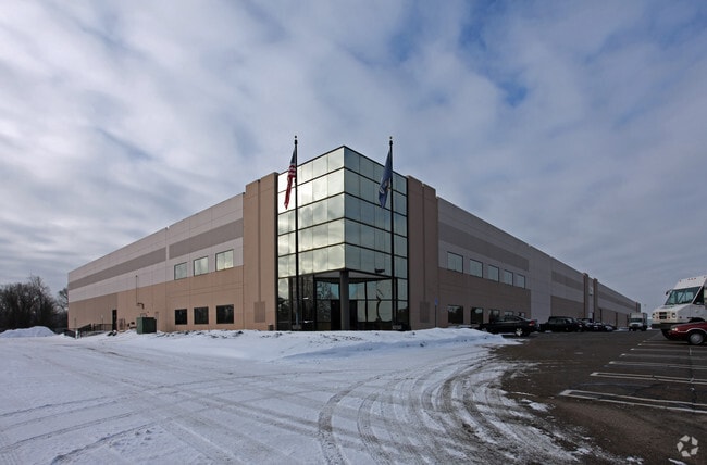
Property Record
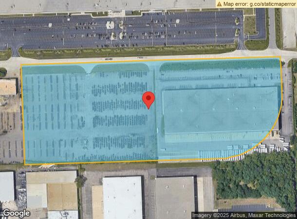
38401 Amrhein Rd, Livonia, MI 48150
NEARBY LISTINGS FOR SALE OR LEASE
Property Detail
38401 Amrhein Rd
46-119-99-0009-004
PART OF S 1/2 SEC 30 T1S R9E DESC AS COMM AT CENTER OF SEC 30 AND POB TH S 89D 45M 00S E 556.89 FT TH S 00D 02M 00S W 33.00 FT TH S 89D 45M 00S E 20.95 FT TH S 00D 16M 18S W 554.04 FT TH N 88D 32M 25S W 232.62 FT TH ALONG CURVE TO RT ARC DIST 235.57
Distributionwarehouseregional
Wayne
X
Michigan
26163C0210E
0009
2025
11.84 AC
2025
Livonia
983301
Detroit
172,094 SF
Detroit-Warren-Dearborn, MI
DEMOGRAPHICS near 38401 Amrhein Rd
1 Mile
3 Mile
5 Mile
2024 Total Population
4,015
69,580
202,593
2029 Population
3,832
66,968
194,122
Pop Growth 2024-2029
(4.56%)
(3.75%)
(4.18%)
Average Age
45
44
43
2024 Total Households
1,807
31,385
86,211
HH Growth 2024-2029
(4.59%)
(3.67%)
(4.15%)
Median Household Inc
$110,150
$83,022
$85,061
Avg Household Size
2.20
2.20
2.30
2024 Avg HH Vehicles
2.00
2.00
2.00
Median Home Value
$253,482
$267,121
$255,061
Median Year Built
1967
1969
1972
Nearby Places
Map Layers
Map Styles
 Street
 Aerial
- Restaurants
- Banks
- Shops
- Fitness
- Groceries
PUBLIC TRANSPORTATION
AIRPORT
Detroit Metro Wayne County
DRIVE
WALK
Distance
Detroit Metro Wayne County
25 min
19.1 mi
Windsor International
DRIVE
WALK
Distance
Windsor International
48 min
32.0 mi
Freight Ports
Port of Toledo
DRIVE
WALK
Distance
Port of Toledo
74 min
60.7 mi
Nearby Properties
Address
Land Use
TOTAL SIZE
Lot Size
Zoning
Address
Land Use
TOTAL SIZE
Lot Size
Zoning
3,733,882 SF
183.17 AC
M-2
Address
Land Use
TOTAL SIZE
Lot Size
Zoning
1,005,040 SF
Address
Land Use
TOTAL SIZE
Lot Size
Zoning
234,403 SF
74.21 AC
OS
Address
Land Use
TOTAL SIZE
Lot Size
Zoning
250,699 SF
16.89 AC
SH
Address
Land Use
TOTAL SIZE
Lot Size
Zoning
37.30 AC
MR
Address
Land Use
TOTAL SIZE
Lot Size
Zoning
517,265 SF
116.72 AC
Address
Land Use
TOTAL SIZE
Lot Size
Zoning
192,478 SF
IND
Address
Land Use
TOTAL SIZE
Lot Size
Zoning
408,122 SF
23.31 AC
MR
Address
Land Use
TOTAL SIZE
Lot Size
Zoning
21.71 AC
MR
Address
Land Use
TOTAL SIZE
Lot Size
Zoning
334,346 SF
55.65 AC
TAR
Address
Land Use
TOTAL SIZE
Lot Size
Zoning
114,894 SF
4.94 AC
ARC
Address
Land Use
TOTAL SIZE
Lot Size
Zoning
352,514 SF
26.40 AC
Address
Land Use
TOTAL SIZE
Lot Size
Zoning
480,910 SF
26.32 AC
Address
Land Use
TOTAL SIZE
Lot Size
Zoning
361,807 SF
18.77 AC
M-2
Address
Land Use
TOTAL SIZE
Lot Size
Zoning
199,485 SF
10.31 AC
R-9
Address
Land Use
TOTAL SIZE
Lot Size
Zoning
730,656 SF
13.73 AC
C-4
Address
Land Use
TOTAL SIZE
Lot Size
Zoning
283,710 SF
IND
Address
Land Use
TOTAL SIZE
Lot Size
Zoning
221,508 SF
26.03 AC
IND
Address
Land Use
TOTAL SIZE
Lot Size
Zoning
113,292 SF
15.79 AC
IND
Address
Land Use
TOTAL SIZE
Lot Size
Zoning
954,882 SF
47.92 AC
LI-2
Address
Land Use
TOTAL SIZE
Lot Size
Zoning
249,795 SF
21.17 AC
Address
Land Use
TOTAL SIZE
Lot Size
Zoning
Address
Land Use
TOTAL SIZE
Lot Size
Zoning
286,188 SF
40.21 AC
Address
Land Use
TOTAL SIZE
Lot Size
Zoning
285,136 SF
15.28 AC
Address
Land Use
TOTAL SIZE
Lot Size
Zoning
243,371 SF
16.04 AC
Address
Land Use
TOTAL SIZE
Lot Size
Zoning
Address
Land Use
TOTAL SIZE
Lot Size
Zoning
544,245 SF
22.30 AC
PO
Address
Land Use
TOTAL SIZE
Lot Size
Zoning
14,023 SF
17.32 AC
RM-1
Address
Land Use
TOTAL SIZE
Lot Size
Zoning
484,535 SF
30.20 AC
IND
The World's #1 Commercial Real Estate Marketplace
Connect with us
© 2025 CoStar Group
The information above has been obtained from sources believed reliable. While we do not doubt its accuracy we have not verified it and make no guarantee, warranty or representation about it. It is your responsibility to independently confirm its accuracy and completeness. Any projections, opinions, assumptions, or estimates used are for example only and do not represent the current or future performance of the property. The value of this transaction to you depends on tax and other factors which should be evaluated by your tax, financial, and legal advisors. You and your advisors should conduct a careful, independent investigation of the property to determine to your satisfaction the suitability of the property for your needs.