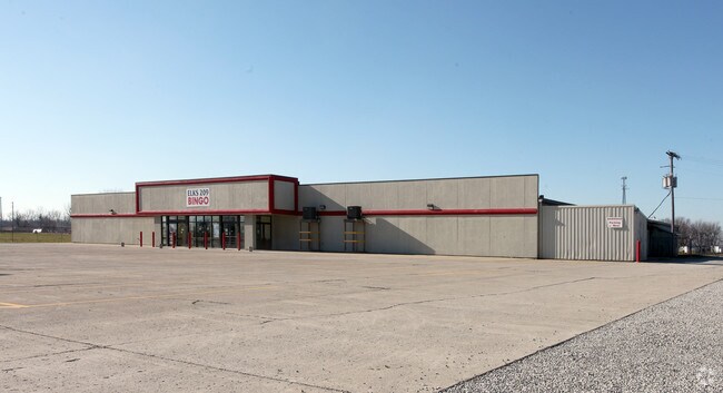
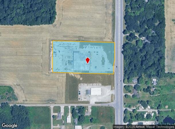
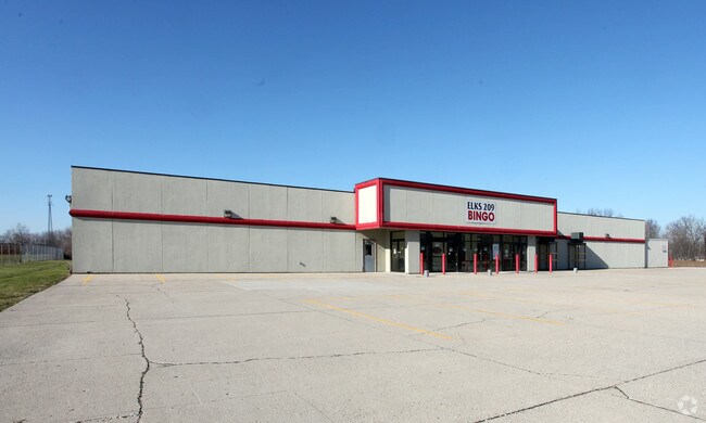
Property Record
3841 N State Road 9, Anderson, IN 46012
NEARBY LISTINGS FOR SALE OR LEASE
Property Detail
3841 N State Road 9
48-08-25-100-004.000-017
NE NE 4.907 ACRES STR: 25207
Storebuilding
Madison
X
Indiana
18095C0195D
4.91 AC
2024
Anderson/Madison Cnty
2025
Indianapolis
010800
Indianapolis-Carmel-Greenwood, IN
31,992 SF
DEMOGRAPHICS near 3841 N State Road 9
1 Mile
3 Mile
5 Mile
2024 Total Population
1,445
12,869
46,297
2029 Population
1,474
13,138
47,947
Pop Growth 2024-2029
+ 2.01%
+ 2.09%
+ 3.56%
Average Age
45
43
41
2024 Total Households
594
5,209
19,037
HH Growth 2024-2029
+ 2.02%
+ 2.23%
+ 3.74%
Median Household Inc
$56,944
$55,166
$47,977
Avg Household Size
2.30
2.30
2.30
2024 Avg HH Vehicles
2.00
2.00
2.00
Median Home Value
$143,181
$135,977
$123,138
Median Year Built
1966
1964
1960
Nearby Places
Map Layers
Map Styles
 Street
 Aerial
- Restaurants
- Banks
- Shops
- Fitness
- Groceries
Nearby Properties
Address
Land Use
TOTAL SIZE
Lot Size
Zoning
Address
Land Use
TOTAL SIZE
Lot Size
Zoning
75,580 SF
21 AC
Address
Land Use
TOTAL SIZE
Lot Size
Zoning
6,162 SF
27.97 AC
Address
Land Use
TOTAL SIZE
Lot Size
Zoning
119,012 SF
14.15 AC
Address
Land Use
TOTAL SIZE
Lot Size
Zoning
59,160 SF
59.78 AC
Address
Land Use
TOTAL SIZE
Lot Size
Zoning
72,158 SF
6 AC
Address
Land Use
TOTAL SIZE
Lot Size
Zoning
31,214 SF
0.19 AC
Address
Land Use
TOTAL SIZE
Lot Size
Zoning
6,240 SF
7.60 AC
Address
Land Use
TOTAL SIZE
Lot Size
Zoning
13,595 SF
3.04 AC
Address
Land Use
TOTAL SIZE
Lot Size
Zoning
12,600 SF
2.56 AC
Address
Land Use
TOTAL SIZE
Lot Size
Zoning
49,350 SF
5.31 AC
Address
Land Use
TOTAL SIZE
Lot Size
Zoning
27,428 SF
132.94 AC
Address
Land Use
TOTAL SIZE
Lot Size
Zoning
72,218 SF
6.59 AC
Address
Land Use
TOTAL SIZE
Lot Size
Zoning
16,233 SF
10.31 AC
Address
Land Use
TOTAL SIZE
Lot Size
Zoning
4,410 SF
1.08 AC
Address
Land Use
TOTAL SIZE
Lot Size
Zoning
9,612 SF
1.37 AC
Address
Land Use
TOTAL SIZE
Lot Size
Zoning
52.85 AC
Address
Land Use
TOTAL SIZE
Lot Size
Zoning
11,880 SF
8.50 AC
Address
Land Use
TOTAL SIZE
Lot Size
Zoning
20,541 SF
2.07 AC
Address
Land Use
TOTAL SIZE
Lot Size
Zoning
11,184 SF
2.90 AC
Address
Land Use
TOTAL SIZE
Lot Size
Zoning
8,880 SF
18.39 AC
Address
Land Use
TOTAL SIZE
Lot Size
Zoning
44,755 SF
2.21 AC
Address
Land Use
TOTAL SIZE
Lot Size
Zoning
8,832 SF
1.88 AC
Address
Land Use
TOTAL SIZE
Lot Size
Zoning
8,186 SF
1.56 AC
Address
Land Use
TOTAL SIZE
Lot Size
Zoning
3,000 SF
3.28 AC
Address
Land Use
TOTAL SIZE
Lot Size
Zoning
88 SF
0.76 AC
Address
Land Use
TOTAL SIZE
Lot Size
Zoning
9,620 SF
4 AC
Address
Land Use
TOTAL SIZE
Lot Size
Zoning
60,348 SF
21.78 AC
Address
Land Use
TOTAL SIZE
Lot Size
Zoning
3,436 SF
1.26 AC
Address
Land Use
TOTAL SIZE
Lot Size
Zoning
26,721 SF
5.38 AC
Address
Land Use
TOTAL SIZE
Lot Size
Zoning
2,441 SF
0.87 AC
The World's #1 Commercial Real Estate Marketplace
Connect with us
© 2026 CoStar Group
The information above has been obtained from sources believed reliable. While we do not doubt its accuracy we have not verified it and make no guarantee, warranty or representation about it. It is your responsibility to independently confirm its accuracy and completeness. Any projections, opinions, assumptions, or estimates used are for example only and do not represent the current or future performance of the property. The value of this transaction to you depends on tax and other factors which should be evaluated by your tax, financial, and legal advisors. You and your advisors should conduct a careful, independent investigation of the property to determine to your satisfaction the suitability of the property for your needs.