Property Record
38425 20Th St E, Palmdale, CA 93550
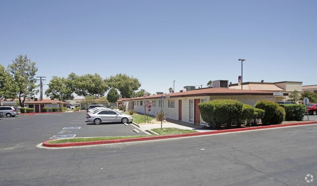

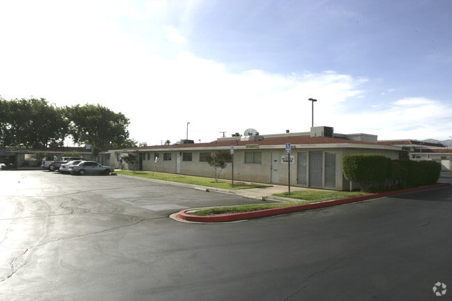

Property Detail
38425 20Th St E
Los Angeles-Long Beach-Glendale, CA
TR=7682*FOR DESC SEE ASSESSORS MAPS POR OF LOT 35
3015-023-025
LOS ANGELES
Regionalshoppingcenterormallwithanchorstore
California
C and X Area of minimal flood hazard, usually depicted on FIRMs as above the 500-year flood level.
35
2024
0.51 AC
2025
Antelope Valley
910502
Los Angeles
5,605 SF
NEARBY LISTINGS FOR SALE OR LEASE
DEMOGRAPHICS near 38425 20Th St E
1 mile
3 mile
5 mile
2025 Total Population
16,305
94,498
147,917
2030 Population
16,199
94,390
147,218
Pop Growth 2025-2030
(0.65%)
(0.11%)
(0.47%)
Average Age
34
36
36
2025 Total Households
4,870
27,440
41,708
HH Growth 2025-2030
(0.76%)
(0.10%)
(0.53%)
Median Household Inc
$54,265
$65,060
$74,739
Avg Household Size
3.30
3.40
3.50
2025 Avg HH Vehicles
2.00
2.00
2.00
Median Home Value
$339,895
$395,232
$435,179
Median Year Built
1981
1985
1988
Nearby Places
Map Layers
Map Styles
 Street
 Aerial
Transit
 Traffic
 Biking
Places
Listings with unknown addresses are not visible on the map
- Restaurants
- Banks
- Shops
- Fitness
- Groceries
PUBLIC TRANSPORTATION
COMMUTER RAIL
Palmdale (Antelope Valley Line - Southern California Regional Rail Authority (Metrolink))
Drive
Walk
Distance
Palmdale (Antelope Valley Line - Southern California Regional Rail Authority (Metrolink))
3 min
2.2 mi
Vincent Grade/Acton (Antelope Valley Line - Southern California Regional Rail Authority (Metrolink))
Drive
Walk
Distance
Vincent Grade/Acton (Antelope Valley Line - Southern California Regional Rail Authority (Metrolink))
12 min
7.3 mi
Freight Ports
Port of Long Beach
Drive
Walk
Distance
Port of Long Beach
102 min
87.4 mi
SALE & LEASE HISTORY
LISTING DATE
SALE/LEASE

Apr 04, 2018
For Sale
Nearby Properties
Address
Land Use
TOTAL SIZE
Lot Size
Zoning
Address
Land Use
TOTAL SIZE
Lot Size
Zoning
2,861,890 SF
528.69 AC
POMA-A25*
Address
Land Use
TOTAL SIZE
Lot Size
Zoning
358,828 SF
26.23 AC
PDR17000
Address
Land Use
TOTAL SIZE
Lot Size
Zoning
130,392 SF
26.91 AC
PDCPD*
Address
Land Use
TOTAL SIZE
Lot Size
Zoning
167,366 SF
15.36 AC
PDC3
Address
Land Use
TOTAL SIZE
Lot Size
Zoning
172,894 SF
14.26 AC
PDC3*
Address
Land Use
TOTAL SIZE
Lot Size
Zoning
50,735 SF
PDCPD
Address
Land Use
TOTAL SIZE
Lot Size
Zoning
101,172 SF
10.22 AC
PDR1*
Address
Land Use
TOTAL SIZE
Lot Size
Zoning
139,513 SF
4.07 AC
PDCPD
Address
Land Use
TOTAL SIZE
Lot Size
Zoning
60,644 SF
3.89 AC
PDMX*
Address
Land Use
TOTAL SIZE
Lot Size
Zoning
103,503 SF
3.61 AC
PDC2
Address
Land Use
TOTAL SIZE
Lot Size
Zoning
64,818 SF
2.30 AC
PDCP
Address
Land Use
TOTAL SIZE
Lot Size
Zoning
221,827 SF
14.90 AC
PDRPD10U-R
Address
Land Use
TOTAL SIZE
Lot Size
Zoning
157,021 SF
PDRN4
Address
Land Use
TOTAL SIZE
Lot Size
Zoning
59,577 SF
0.59 AC
PDR17000
Address
Land Use
TOTAL SIZE
Lot Size
Zoning
209,328 SF
6.35 AC
PDC3-RPD15
Address
Land Use
TOTAL SIZE
Lot Size
Zoning
71,394 SF
2.93 AC
PDCPD*
Address
Land Use
TOTAL SIZE
Lot Size
Zoning
76,609 SF
3.61 AC
PDM2
Address
Land Use
TOTAL SIZE
Lot Size
Zoning
2,908,124 SF
126.15 AC
LCM21/2*
Address
Land Use
TOTAL SIZE
Lot Size
Zoning
144,471 SF
12.96 AC
PDCPD-MPD*
Address
Land Use
TOTAL SIZE
Lot Size
Zoning
80,981 SF
7.11 AC
PDC3
Address
Land Use
TOTAL SIZE
Lot Size
Zoning
55,079 SF
1.98 AC
PDCPD*
Address
Land Use
TOTAL SIZE
Lot Size
Zoning
71,974 SF
3.83 AC
PDCPD*
Address
Land Use
TOTAL SIZE
Lot Size
Zoning
207,582 SF
18.74 AC
PDR1*
Address
Land Use
TOTAL SIZE
Lot Size
Zoning
115,800 SF
11.51 AC
PDCPD-MPD*
Address
Land Use
TOTAL SIZE
Lot Size
Zoning
49,138 SF
2.30 AC
PDCP
Address
Land Use
TOTAL SIZE
Lot Size
Zoning
81,790 SF
5.70 AC
PDR1*
Address
Land Use
TOTAL SIZE
Lot Size
Zoning
78,176 SF
6.11 AC
PDR1*
Address
Land Use
TOTAL SIZE
Lot Size
Zoning
108,762 SF
4.22 AC
PDR3
Address
Land Use
TOTAL SIZE
Lot Size
Zoning
81,512 SF
4.25 AC
PDR1*
Address
Land Use
TOTAL SIZE
Lot Size
Zoning
67,560 SF
5.12 AC
PDR1*
The World's #1 Commercial Real Estate Marketplace
Connect with us
© 2026 CoStar Group
The information above has been obtained from sources believed reliable. While we do not doubt its accuracy we have not verified it and make no guarantee, warranty or representation about it. It is your responsibility to independently confirm its accuracy and completeness. Any projections, opinions, assumptions, or estimates used are for example only and do not represent the current or future performance of the property. The value of this transaction to you depends on tax and other factors which should be evaluated by your tax, financial, and legal advisors. You and your advisors should conduct a careful, independent investigation of the property to determine to your satisfaction the suitability of the property for your needs.