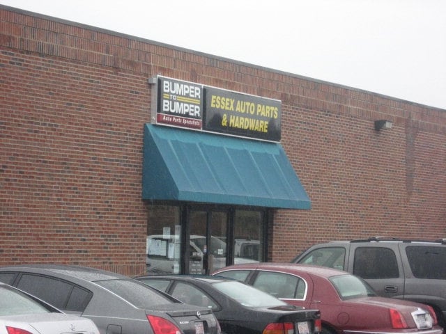
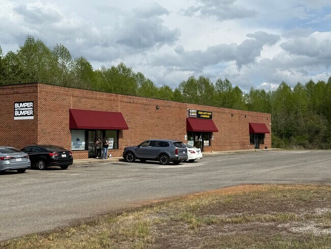
Property Record
38437 Highway 561, , NC
Property Detail
38437 Highway 561
01-06453
MILLER LD
Commercialnec
Halifax
X
North Carolina
3720390000K
4 AC
2024
North Carolina Northeast Area
2025
Other Market Areas
930800
Roanoke Rapids, NC
10,500 SF
NEARBY LISTINGS FOR SALE OR LEASE
-
-
View all listings for sale on LoopNet.com
DEMOGRAPHICS near 38437 Highway 561
1 mile
3 mile
5 mile
2024 Total Population
450
2,049
3,456
2029 Population
431
1,990
3,373
Pop Growth 2024-2029
(4.22%)
(2.88%)
(2.40%)
Average Age
43
43
43
2024 Total Households
190
862
1,455
HH Growth 2024-2029
(4.21%)
(2.90%)
(2.47%)
Median Household Inc
$36,052
$36,737
$36,613
Avg Household Size
2.20
2.30
2.30
2024 Avg HH Vehicles
2.00
2.00
2.00
Median Home Value
$86,708
$86,920
$87,299
Median Year Built
1987
1987
1988
Nearby Places
Map Layers
Map Styles
 Street
 Aerial
Transit
 Traffic
 Biking
Places
Listings with unknown addresses are not visible on the map
- Restaurants
- Banks
- Shops
- Fitness
- Groceries
SALE & LEASE HISTORY
LISTING DATE
SALE/LEASE

Jun 09, 2025
For Sale
Nearby Properties
Address
Land Use
TOTAL SIZE
Lot Size
Zoning
Address
Land Use
TOTAL SIZE
Lot Size
Zoning
13,557 SF
5.79 AC
Address
Land Use
TOTAL SIZE
Lot Size
Zoning
11,948 SF
2.20 AC
Address
Land Use
TOTAL SIZE
Lot Size
Zoning
23,634 SF
7.26 AC
Address
Land Use
TOTAL SIZE
Lot Size
Zoning
4,582 SF
5 AC
Address
Land Use
TOTAL SIZE
Lot Size
Zoning
3,402 SF
4.66 AC
Address
Land Use
TOTAL SIZE
Lot Size
Zoning
9,180 SF
2.34 AC
Address
Land Use
TOTAL SIZE
Lot Size
Zoning
11,628 SF
31.30 AC
Address
Land Use
TOTAL SIZE
Lot Size
Zoning
5,466 SF
2 AC
Address
Land Use
TOTAL SIZE
Lot Size
Zoning
4,452 SF
1 AC
Address
Land Use
TOTAL SIZE
Lot Size
Zoning
2,056 SF
307.58 AC
RV0907
Address
Land Use
TOTAL SIZE
Lot Size
Zoning
2,219 SF
2.19 AC
Address
Land Use
TOTAL SIZE
Lot Size
Zoning
1,960 SF
18 AC
Address
Land Use
TOTAL SIZE
Lot Size
Zoning
8,273 SF
1.69 AC
Address
Land Use
TOTAL SIZE
Lot Size
Zoning
8,946 SF
1.21 AC
Address
Land Use
TOTAL SIZE
Lot Size
Zoning
2,568 SF
3.77 AC
Address
Land Use
TOTAL SIZE
Lot Size
Zoning
8,160 SF
2.12 AC
Address
Land Use
TOTAL SIZE
Lot Size
Zoning
7,676 SF
8.77 AC
Address
Land Use
TOTAL SIZE
Lot Size
Zoning
4,670 SF
3.17 AC
A1
Address
Land Use
TOTAL SIZE
Lot Size
Zoning
6,677 SF
3 AC
Address
Land Use
TOTAL SIZE
Lot Size
Zoning
5,927 SF
12.17 AC
Address
Land Use
TOTAL SIZE
Lot Size
Zoning
2,585 SF
3.11 AC
Address
Land Use
TOTAL SIZE
Lot Size
Zoning
1,942 SF
0.99 AC
Address
Land Use
TOTAL SIZE
Lot Size
Zoning
2,745 SF
2.31 AC
Address
Land Use
TOTAL SIZE
Lot Size
Zoning
2,276 SF
2.52 AC
Address
Land Use
TOTAL SIZE
Lot Size
Zoning
3,031 SF
2.38 AC
Address
Land Use
TOTAL SIZE
Lot Size
Zoning
2,756 SF
21.93 AC
Address
Land Use
TOTAL SIZE
Lot Size
Zoning
5,376 SF
16.93 AC
RV1013
Address
Land Use
TOTAL SIZE
Lot Size
Zoning
2,070 SF
0.96 AC
The World's #1 Commercial Real Estate Marketplace
Connect with us
© 2026 CoStar Group
The information above has been obtained from sources believed reliable. While we do not doubt its accuracy we have not verified it and make no guarantee, warranty or representation about it. It is your responsibility to independently confirm its accuracy and completeness. Any projections, opinions, assumptions, or estimates used are for example only and do not represent the current or future performance of the property. The value of this transaction to you depends on tax and other factors which should be evaluated by your tax, financial, and legal advisors. You and your advisors should conduct a careful, independent investigation of the property to determine to your satisfaction the suitability of the property for your needs.