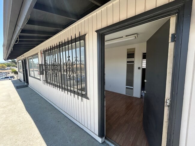
Property Record
3845 Stobbs Way, Jurupa Valley, CA 92509

Current Lease Availabilities
NEARBY LISTINGS FOR SALE OR LEASE
Property Detail
3845 Stobbs Way
Riverside-San Bernardino-Ontario, CA
West Riverside
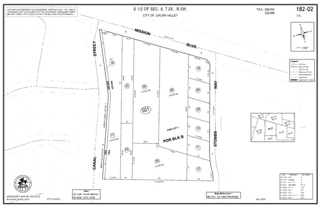
182-021-009
.27 ACRES M/L IN POR LOT 1 BLK B MB 009/034 SB WEST RIVERSIDE
Storebuilding
Riverside
X
California
06065C0043H
1
2024
0.27 AC
2025
Riverside
040305
Inland Empire (California)
7,900 SF
DEMOGRAPHICS near 3845 Stobbs Way
1 Mile
3 Mile
5 Mile
2024 Total Population
14,064
70,613
258,108
2029 Population
14,787
73,739
268,475
Pop Growth 2024-2029
+ 5.14%
+ 4.43%
+ 4.02%
Average Age
36
35
36
2024 Total Households
3,483
18,320
71,844
HH Growth 2024-2029
+ 4.71%
+ 4.04%
+ 3.78%
Median Household Inc
$82,143
$83,768
$75,729
Avg Household Size
3.70
3.60
3.40
2024 Avg HH Vehicles
3.00
3.00
2.00
Median Home Value
$431,323
$451,097
$435,224
Median Year Built
1976
1980
1974
Nearby Places
Map Layers
Map Styles
 Street
 Aerial
- Restaurants
- Banks
- Shops
- Fitness
- Groceries
PUBLIC TRANSPORTATION
COMMUTER RAIL
Pedley (Riverside Line - Southern California Regional Rail Authority (Metrolink))
DRIVE
WALK
Distance
Pedley (Riverside Line - Southern California Regional Rail Authority (Metrolink))
9 min
5.4 mi
Riverside-Downtown (91 Line - Southern California Regional Rail Authority (Metrolink), Inland Empire-Orange County Line - Southern California Regional Rail Authority (Metrolink), Riverside Line - Southern California Regional Rail Authority (Metrolink))
DRIVE
WALK
Distance
Riverside-Downtown (91 Line - Southern California Regional Rail Authority (Metrolink), Inland Empire-Orange County Line - Southern California Regional Rail Authority (Metrolink), Riverside Line - Southern California Regional Rail Authority (Metrolink))
12 min
7.3 mi
AIRPORT
Ontario International
DRIVE
WALK
Distance
Ontario International
18 min
11.9 mi
John Wayne/Orange County
DRIVE
WALK
Distance
John Wayne/Orange County
48 min
47.9 mi
Nearby Properties
Address
Land Use
TOTAL SIZE
Lot Size
Zoning
Address
Land Use
TOTAL SIZE
Lot Size
Zoning
1,025,132 SF
46.44 AC
Address
Land Use
TOTAL SIZE
Lot Size
Zoning
1,000,177 SF
46 AC
Address
Land Use
TOTAL SIZE
Lot Size
Zoning
210,004 SF
11.68 AC
Address
Land Use
TOTAL SIZE
Lot Size
Zoning
70.13 AC
Address
Land Use
TOTAL SIZE
Lot Size
Zoning
244,495 SF
17.53 AC
MH
Address
Land Use
TOTAL SIZE
Lot Size
Zoning
122,023 SF
6.83 AC
Address
Land Use
TOTAL SIZE
Lot Size
Zoning
272,472 SF
24.49 AC
N2
Address
Land Use
TOTAL SIZE
Lot Size
Zoning
52.42 AC
Address
Land Use
TOTAL SIZE
Lot Size
Zoning
180,215 SF
14.73 AC
Address
Land Use
TOTAL SIZE
Lot Size
Zoning
139.49 AC
Address
Land Use
TOTAL SIZE
Lot Size
Zoning
16.90 AC
MSC
Address
Land Use
TOTAL SIZE
Lot Size
Zoning
23.33 AC
Address
Land Use
TOTAL SIZE
Lot Size
Zoning
124,058 SF
10.75 AC
MH
Address
Land Use
TOTAL SIZE
Lot Size
Zoning
89,920 SF
6.92 AC
CP
Address
Land Use
TOTAL SIZE
Lot Size
Zoning
6,664 SF
15.89 AC
C1CP
Address
Land Use
TOTAL SIZE
Lot Size
Zoning
118,445 SF
17.90 AC
Address
Land Use
TOTAL SIZE
Lot Size
Zoning
36,395 SF
5.22 AC
MH
Address
Land Use
TOTAL SIZE
Lot Size
Zoning
6.45 AC
CPS
Address
Land Use
TOTAL SIZE
Lot Size
Zoning
74,853 SF
3.81 AC
MH
Address
Land Use
TOTAL SIZE
Lot Size
Zoning
83,858 SF
2.53 AC
Address
Land Use
TOTAL SIZE
Lot Size
Zoning
53,606 SF
3.13 AC
Address
Land Use
TOTAL SIZE
Lot Size
Zoning
25,357 SF
3.16 AC
RR
Address
Land Use
TOTAL SIZE
Lot Size
Zoning
92,960 SF
4.43 AC
C1CP
Address
Land Use
TOTAL SIZE
Lot Size
Zoning
44,729 SF
2.60 AC
Address
Land Use
TOTAL SIZE
Lot Size
Zoning
78,390 SF
5.02 AC
R3
Address
Land Use
TOTAL SIZE
Lot Size
Zoning
44,544 SF
1.92 AC
Address
Land Use
TOTAL SIZE
Lot Size
Zoning
5,670 SF
10.06 AC
MIX
Address
Land Use
TOTAL SIZE
Lot Size
Zoning
110,088 SF
23.83 AC
R4
The World's #1 Commercial Real Estate Marketplace
Connect with us
© 2025 CoStar Group
The information above has been obtained from sources believed reliable. While we do not doubt its accuracy we have not verified it and make no guarantee, warranty or representation about it. It is your responsibility to independently confirm its accuracy and completeness. Any projections, opinions, assumptions, or estimates used are for example only and do not represent the current or future performance of the property. The value of this transaction to you depends on tax and other factors which should be evaluated by your tax, financial, and legal advisors. You and your advisors should conduct a careful, independent investigation of the property to determine to your satisfaction the suitability of the property for your needs.