Property Record
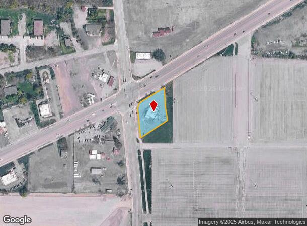
3847 Southwestern Blvd, Orchard Park, NY 14127
NEARBY LISTINGS FOR SALE OR LEASE
Property Detail
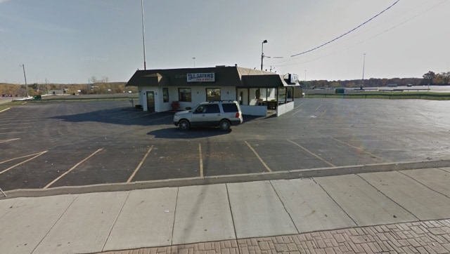
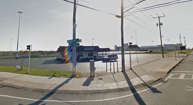
3847 Southwestern Blvd
146089-161-000-0005-018-000
SE COR S W BLVD ABBOTT RD 200 X 200
Restaurantbuilding
Erie
X
New York
36029C0343H
18.000
2025
0.73 AC
2024
South
013701
Buffalo/Niagara Falls
2,272 SF
Buffalo-Cheektowaga-Niagara Falls, NY
DEMOGRAPHICS near 3847 Southwestern Blvd
1 Mile
3 Mile
5 Mile
2024 Total Population
4,309
47,143
135,914
2029 Population
4,316
47,071
135,243
Pop Growth 2024-2029
+ 0.16%
(0.15%)
(0.49%)
Average Age
43
44
43
2024 Total Households
1,989
20,788
58,315
HH Growth 2024-2029
+ 0.30%
(0.22%)
(0.58%)
Median Household Inc
$59,462
$69,803
$70,070
Avg Household Size
2.10
2.20
2.30
2024 Avg HH Vehicles
2.00
2.00
2.00
Median Home Value
$202,834
$209,095
$202,860
Median Year Built
1976
1971
1964
Nearby Places
- Restaurants
- Banks
- Shops
- Fitness
- Groceries
PUBLIC TRANSPORTATION
AIRPORT
Buffalo Niagara International
DRIVE
WALK
Distance
Buffalo Niagara International
27 min
17.0 mi
Niagara Falls International
DRIVE
WALK
Distance
Niagara Falls International
46 min
30.5 mi
Freight Ports
Port of Toledo
DRIVE
WALK
Distance
Port of Toledo
349 min
296.3 mi
SALE & LEASE HISTORY
LISTING DATE
SALE/LEASE

Sep 25, 2016
For Lease
Nearby Properties
Address
Land Use
TOTAL SIZE
Lot Size
Zoning
Address
Land Use
TOTAL SIZE
Lot Size
Zoning
49,500 SF
108.40 AC
R1
Address
Land Use
TOTAL SIZE
Lot Size
Zoning
22,754 SF
41.80 AC
Address
Land Use
TOTAL SIZE
Lot Size
Zoning
183,334 SF
50.90 AC
B2
Address
Land Use
TOTAL SIZE
Lot Size
Zoning
184,188 SF
110.75 AC
Address
Land Use
TOTAL SIZE
Lot Size
Zoning
77,270 SF
46.15 AC
C3
Address
Land Use
TOTAL SIZE
Lot Size
Zoning
337,198 SF
51.05 AC
M1
Address
Land Use
TOTAL SIZE
Lot Size
Zoning
197,584 SF
32.50 AC
B2
Address
Land Use
TOTAL SIZE
Lot Size
Zoning
48.14 AC
OP
Address
Land Use
TOTAL SIZE
Lot Size
Zoning
18,840 SF
114.12 AC
M3
Address
Land Use
TOTAL SIZE
Lot Size
Zoning
118,358 SF
59.67 AC
Address
Land Use
TOTAL SIZE
Lot Size
Zoning
115,317 SF
17.87 AC
DR
Address
Land Use
TOTAL SIZE
Lot Size
Zoning
124,112 SF
53.10 AC
05 - COMME
Address
Land Use
TOTAL SIZE
Lot Size
Zoning
149,065 SF
21.53 AC
B2
Address
Land Use
TOTAL SIZE
Lot Size
Zoning
59,421 SF
75.40 AC
B1
Address
Land Use
TOTAL SIZE
Lot Size
Zoning
202,597 SF
24.22 AC
Address
Land Use
TOTAL SIZE
Lot Size
Zoning
97,709 SF
14.13 AC
R2
Address
Land Use
TOTAL SIZE
Lot Size
Zoning
91,618 SF
11.30 AC
Address
Land Use
TOTAL SIZE
Lot Size
Zoning
165,478 SF
9.79 AC
Address
Land Use
TOTAL SIZE
Lot Size
Zoning
10,486 SF
25.30 AC
R3
Address
Land Use
TOTAL SIZE
Lot Size
Zoning
28,578 SF
10.46 AC
C1
Address
Land Use
TOTAL SIZE
Lot Size
Zoning
221,896 SF
21.50 AC
Address
Land Use
TOTAL SIZE
Lot Size
Zoning
8,320 SF
22.10 AC
Address
Land Use
TOTAL SIZE
Lot Size
Zoning
149,858 SF
24.18 AC
Address
Land Use
TOTAL SIZE
Lot Size
Zoning
103,215 SF
6.14 AC
C1
Address
Land Use
TOTAL SIZE
Lot Size
Zoning
102,037 SF
9.95 AC
C2
Address
Land Use
TOTAL SIZE
Lot Size
Zoning
13,062 SF
26.07 AC
R4
Address
Land Use
TOTAL SIZE
Lot Size
Zoning
3,361 SF
28.04 AC
R3
Address
Land Use
TOTAL SIZE
Lot Size
Zoning
143,400 SF
11.33 AC
B1
Address
Land Use
TOTAL SIZE
Lot Size
Zoning
111,225 SF
10.52 AC
C2
Address
Land Use
TOTAL SIZE
Lot Size
Zoning
7,448 SF
24.51 AC
R3
The World's #1 Commercial Real Estate Marketplace
Connect with us
© 2025 CoStar Group
The information above has been obtained from sources believed reliable. While we do not doubt its accuracy we have not verified it and make no guarantee, warranty or representation about it. It is your responsibility to independently confirm its accuracy and completeness. Any projections, opinions, assumptions, or estimates used are for example only and do not represent the current or future performance of the property. The value of this transaction to you depends on tax and other factors which should be evaluated by your tax, financial, and legal advisors. You and your advisors should conduct a careful, independent investigation of the property to determine to your satisfaction the suitability of the property for your needs.