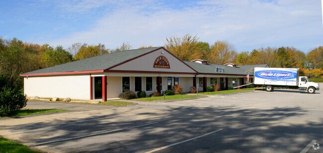
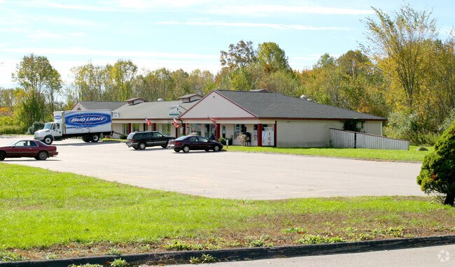
Property Record
385 Beaumont Hwy, Lebanon, CT 06249

NEARBY LISTINGS FOR SALE OR LEASE
Property Detail
385 Beaumont Hwy
LEBA-000209-000000-000001
New London
Commercialbuilding
Connecticut
X
1
09015C0325F
14.93 AC
2024
NW New London/Colchester
2025
Hartford
870100
Norwich-New London, CT
7,392 SF
DEMOGRAPHICS near 385 Beaumont Hwy
1 Mile
3 Mile
5 Mile
2024 Total Population
414
14,441
35,360
2029 Population
407
14,391
35,317
Pop Growth 2024-2029
(1.69%)
(0.35%)
(0.12%)
Average Age
42
38
39
2024 Total Households
152
5,265
13,066
HH Growth 2024-2029
(1.97%)
(0.42%)
(0.24%)
Median Household Inc
$85,416
$57,336
$56,180
Avg Household Size
2.70
2.40
2.40
2024 Avg HH Vehicles
2.00
2.00
2.00
Median Home Value
$342,592
$211,891
$225,798
Median Year Built
1982
1956
1967
Nearby Places
Map Layers
Map Styles
 Street
 Aerial
- Restaurants
- Banks
- Shops
- Fitness
- Groceries
PUBLIC TRANSPORTATION
AIRPORT
Bradley International
DRIVE
WALK
Distance
Bradley International
71 min
45.0 mi
Freight Ports
Port of Davisville, RI
DRIVE
WALK
Distance
Port of Davisville, RI
89 min
53.4 mi
SALE & LEASE HISTORY
LISTING DATE
SALE/LEASE

Dec 12, 2017
For Lease
Nearby Properties
Address
Land Use
TOTAL SIZE
Lot Size
Zoning
Address
Land Use
TOTAL SIZE
Lot Size
Zoning
14.62 AC
B4
Address
Land Use
TOTAL SIZE
Lot Size
Zoning
73,691 SF
R6
Address
Land Use
TOTAL SIZE
Lot Size
Zoning
68,508 SF
R6
Address
Land Use
TOTAL SIZE
Lot Size
Zoning
57,648 SF
R6
Address
Land Use
TOTAL SIZE
Lot Size
Zoning
158,766 SF
3.91 AC
R6
Address
Land Use
TOTAL SIZE
Lot Size
Zoning
300,483 SF
R6
Address
Land Use
TOTAL SIZE
Lot Size
Zoning
3.50 AC
R6
Address
Land Use
TOTAL SIZE
Lot Size
Zoning
64,490 SF
R6
Address
Land Use
TOTAL SIZE
Lot Size
Zoning
58,264 SF
5.97 AC
B2A
Address
Land Use
TOTAL SIZE
Lot Size
Zoning
37,665 SF
0.42 AC
B1
Address
Land Use
TOTAL SIZE
Lot Size
Zoning
34,087 SF
0.68 AC
B1
Address
Land Use
TOTAL SIZE
Lot Size
Zoning
71,976 SF
3.15 AC
R6
Address
Land Use
TOTAL SIZE
Lot Size
Zoning
14.59 AC
R5
Address
Land Use
TOTAL SIZE
Lot Size
Zoning
20,783 SF
R6
Address
Land Use
TOTAL SIZE
Lot Size
Zoning
7.38 AC
M4
Address
Land Use
TOTAL SIZE
Lot Size
Zoning
38,605 SF
60.23 AC
R2
Address
Land Use
TOTAL SIZE
Lot Size
Zoning
104,500 SF
2.10 AC
PDD4
Address
Land Use
TOTAL SIZE
Lot Size
Zoning
73,189 SF
2.46 AC
R6
Address
Land Use
TOTAL SIZE
Lot Size
Zoning
48,770 SF
4.06 AC
B2
Address
Land Use
TOTAL SIZE
Lot Size
Zoning
31,818 SF
4.35 AC
B4
Address
Land Use
TOTAL SIZE
Lot Size
Zoning
107,256 SF
0.31 AC
B1
Address
Land Use
TOTAL SIZE
Lot Size
Zoning
2.05 AC
B1A
Address
Land Use
TOTAL SIZE
Lot Size
Zoning
2.22 AC
B1A
Address
Land Use
TOTAL SIZE
Lot Size
Zoning
22.10 AC
R6
Address
Land Use
TOTAL SIZE
Lot Size
Zoning
29,548 SF
2.96 AC
RPO
Address
Land Use
TOTAL SIZE
Lot Size
Zoning
2.20 AC
B4
Address
Land Use
TOTAL SIZE
Lot Size
Zoning
61,574 SF
5.10 AC
B2
Address
Land Use
TOTAL SIZE
Lot Size
Zoning
31,618 SF
2.60 AC
R6
Address
Land Use
TOTAL SIZE
Lot Size
Zoning
Address
Land Use
TOTAL SIZE
Lot Size
Zoning
14,805 SF
3.60 AC
B4
The World's #1 Commercial Real Estate Marketplace
Connect with us
© 2026 CoStar Group
The information above has been obtained from sources believed reliable. While we do not doubt its accuracy we have not verified it and make no guarantee, warranty or representation about it. It is your responsibility to independently confirm its accuracy and completeness. Any projections, opinions, assumptions, or estimates used are for example only and do not represent the current or future performance of the property. The value of this transaction to you depends on tax and other factors which should be evaluated by your tax, financial, and legal advisors. You and your advisors should conduct a careful, independent investigation of the property to determine to your satisfaction the suitability of the property for your needs.