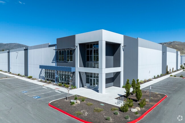
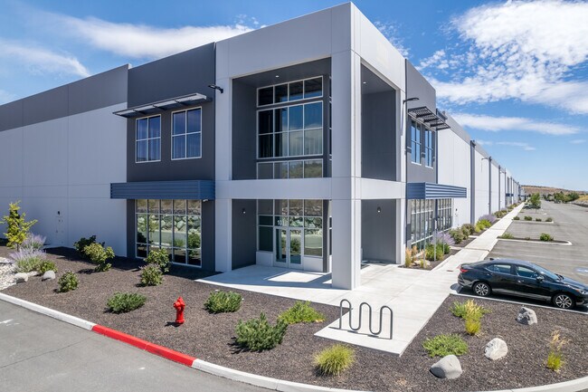
Property Record
385 Cabela Dr, Verdi, NV 89439

Property Detail
385 Cabela Dr
038-870-36
PM 5391 LOT 3
Industrialgeneral
Washoe
IC
Nevada
B and X Area of moderate flood hazard, usually the area between the limits of the 100-year and 500-year floods.
3
2025
13.81 AC
2026
S Outlying Washoe Cty
002302
Reno/Sparks
206,891 SF
Reno, NV
NEARBY LISTINGS FOR SALE OR LEASE
DEMOGRAPHICS near 385 Cabela Dr
1 mile
3 mile
5 mile
2025 Total Population
1,971
9,576
27,245
2030 Population
2,081
9,919
28,020
Pop Growth 2025-2030
+ 5.58%
+ 3.58%
+ 2.84%
Average Age
47
51
44
2025 Total Households
867
4,202
11,320
HH Growth 2025-2030
+ 5.88%
+ 3.81%
+ 3.02%
Median Household Inc
$93,847
$132,458
$110,579
Avg Household Size
2.20
2.20
2.40
2025 Avg HH Vehicles
2.00
2.00
2.00
Median Home Value
$748,086
$750,575
$700,459
Median Year Built
2002
2007
2002
Nearby Places
Map Layers
Map Styles
 Street
 Aerial
Transit
 Traffic
 Biking
Places
Listings with unknown addresses are not visible on the map
- Restaurants
- Banks
- Shops
- Fitness
- Groceries
PUBLIC TRANSPORTATION
AIRPORT
Reno/Tahoe International
Drive
Walk
Distance
Reno/Tahoe International
38 min
16.6 mi
Freight Ports
Port of Stockton
Drive
Walk
Distance
Port of Stockton
199 min
170.8 mi
SALE & LEASE HISTORY
LISTING DATE
SALE/LEASE

Nov 15, 2019
For Lease
Jun 08, 2023
For Lease
Jan 12, 2018
For Lease
Aug 08, 2024
For Lease
Nearby Properties
Address
Land Use
TOTAL SIZE
Lot Size
Zoning
Address
Land Use
TOTAL SIZE
Lot Size
Zoning
252,869 SF
10.77 AC
MF14 97% /
Address
Land Use
TOTAL SIZE
Lot Size
Zoning
359,209 SF
8.83 AC
HC
Address
Land Use
TOTAL SIZE
Lot Size
Zoning
257,834 SF
14.94 AC
MS
Address
Land Use
TOTAL SIZE
Lot Size
Zoning
127,616 SF
20.80 AC
AC
Address
Land Use
TOTAL SIZE
Lot Size
Zoning
221,000 SF
13.78 AC
IC
Address
Land Use
TOTAL SIZE
Lot Size
Zoning
170,090 SF
11.60 AC
MS 91% / S
Address
Land Use
TOTAL SIZE
Lot Size
Zoning
182,000 SF
13.56 AC
IC
Address
Land Use
TOTAL SIZE
Lot Size
Zoning
1,200 SF
34.91 AC
MS
Address
Land Use
TOTAL SIZE
Lot Size
Zoning
182,656 SF
10.50 AC
IC
Address
Land Use
TOTAL SIZE
Lot Size
Zoning
480.53 AC
PGOS 45% /
Address
Land Use
TOTAL SIZE
Lot Size
Zoning
440 AC
SF6 15% /
Address
Land Use
TOTAL SIZE
Lot Size
Zoning
115,848 SF
9.61 AC
PD
Address
Land Use
TOTAL SIZE
Lot Size
Zoning
14,540 SF
8.90 AC
HC
Address
Land Use
TOTAL SIZE
Lot Size
Zoning
6,793.88 AC
OS
Address
Land Use
TOTAL SIZE
Lot Size
Zoning
133,701 SF
21.38 AC
I
Address
Land Use
TOTAL SIZE
Lot Size
Zoning
23,438 SF
11.25 AC
MS
Address
Land Use
TOTAL SIZE
Lot Size
Zoning
2,438 SF
1.27 AC
OS 28%/PF
Address
Land Use
TOTAL SIZE
Lot Size
Zoning
22,703 SF
5.43 AC
GC
Address
Land Use
TOTAL SIZE
Lot Size
Zoning
242.86 AC
SF9 12% /
Address
Land Use
TOTAL SIZE
Lot Size
Zoning
88,560 SF
4 AC
I
Address
Land Use
TOTAL SIZE
Lot Size
Zoning
643.88 AC
SF6 13% /
Address
Land Use
TOTAL SIZE
Lot Size
Zoning
678 SF
76.94 AC
SF6 34%/ S
Address
Land Use
TOTAL SIZE
Lot Size
Zoning
35.39 AC
GF
Address
Land Use
TOTAL SIZE
Lot Size
Zoning
12,003 SF
18.23 AC
GR
Address
Land Use
TOTAL SIZE
Lot Size
Zoning
24,752 SF
1.37 AC
SPD
Address
Land Use
TOTAL SIZE
Lot Size
Zoning
49.20 AC
RR15
Address
Land Use
TOTAL SIZE
Lot Size
Zoning
61.14 AC
OS 29% / A
Address
Land Use
TOTAL SIZE
Lot Size
Zoning
16,905 SF
4.33 AC
I
Address
Land Use
TOTAL SIZE
Lot Size
Zoning
42,026 SF
5.79 AC
PD
The World's #1 Commercial Real Estate Marketplace
Connect with us
© 2026 CoStar Group
The information above has been obtained from sources believed reliable. While we do not doubt its accuracy we have not verified it and make no guarantee, warranty or representation about it. It is your responsibility to independently confirm its accuracy and completeness. Any projections, opinions, assumptions, or estimates used are for example only and do not represent the current or future performance of the property. The value of this transaction to you depends on tax and other factors which should be evaluated by your tax, financial, and legal advisors. You and your advisors should conduct a careful, independent investigation of the property to determine to your satisfaction the suitability of the property for your needs.