Property Record
385 Danbury Rd, Wilton, CT 06897

Property Detail
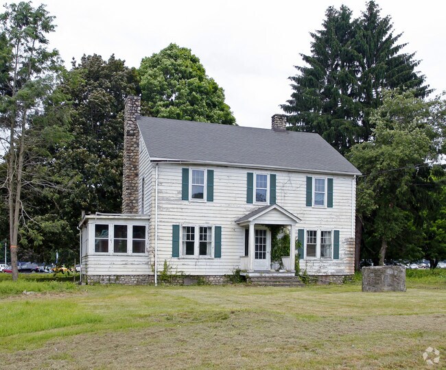
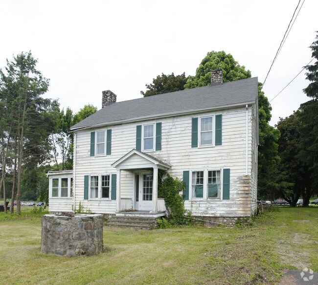
385 Danbury Rd
Commercialbuilding
Western Ct
DRB
Connecticut
C and X Area of minimal flood hazard, usually depicted on FIRMs as above the 500-year flood level.
1.95 AC
2025
Wilton
2025
Westchester/So Connecticut
045200
Bridgeport-Stamford-Danbury, CT
8,468 SF
WILT-000059-000005
NEARBY LISTINGS FOR SALE OR LEASE
DEMOGRAPHICS near 385 Danbury Rd
1 mile
3 mile
5 mile
2025 Total Population
2,021
18,999
59,184
2030 Population
2,100
19,568
60,898
Pop Growth 2025-2030
+ 3.91%
+ 2.99%
+ 2.90%
Average Age
45
42
42
2025 Total Households
644
6,376
20,942
HH Growth 2025-2030
+ 4.19%
+ 3.00%
+ 2.93%
Median Household Inc
$174,431
$220,451
$204,445
Avg Household Size
2.90
2.90
2.80
2025 Avg HH Vehicles
2.00
2.00
2.00
Median Home Value
$1,031,784
$931,117
$899,573
Median Year Built
1982
1970
1970
Nearby Places
Map Layers
Map Styles
 Street
 Aerial
Layers
 Traffic
 Biking
Places
Listings with unknown addresses are not visible on the map
- Restaurants
- Banks
- Shops
- Fitness
- Groceries
PUBLIC TRANSPORTATION
COMMUTER RAIL
Cannondale Station (New Haven Line - Metro-North Commuter Railroad Company (Metro-North))
Drive
Walk
Distance
Cannondale Station (New Haven Line - Metro-North Commuter Railroad Company (Metro-North))
2 min
0.8 mi
Wilton Station (New Haven Line - Metro-North Commuter Railroad Company (Metro-North))
Drive
Walk
Distance
Wilton Station (New Haven Line - Metro-North Commuter Railroad Company (Metro-North))
2 min
19 min
1.0 mi
AIRPORT
Westchester County
Drive
Walk
Distance
Westchester County
38 min
26.2 mi
Tweed/New Haven
Drive
Walk
Distance
Tweed/New Haven
58 min
37.1 mi
Freight Ports
Port of New Haven
Drive
Walk
Distance
Port of New Haven
52 min
34.9 mi
Nearby Properties
Address
Land Use
TOTAL SIZE
Lot Size
Zoning
Address
Land Use
TOTAL SIZE
Lot Size
Zoning
28.64 AC
DE-10
Address
Land Use
TOTAL SIZE
Lot Size
Zoning
82.14 AC
R-2
Address
Land Use
TOTAL SIZE
Lot Size
Zoning
109.27 AC
R-2
Address
Land Use
TOTAL SIZE
Lot Size
Zoning
196,084 SF
4.34 AC
DE-5
Address
Land Use
TOTAL SIZE
Lot Size
Zoning
260,868 SF
C
Address
Land Use
TOTAL SIZE
Lot Size
Zoning
24.67 AC
DE-10
Address
Land Use
TOTAL SIZE
Lot Size
Zoning
111,713 SF
C
Address
Land Use
TOTAL SIZE
Lot Size
Zoning
12.32 AC
CRA-1
Address
Land Use
TOTAL SIZE
Lot Size
Zoning
34.16 AC
R-2
Address
Land Use
TOTAL SIZE
Lot Size
Zoning
160,264 SF
C
Address
Land Use
TOTAL SIZE
Lot Size
Zoning
10.64 AC
HODD
Address
Land Use
TOTAL SIZE
Lot Size
Zoning
32.55 AC
DE-10
Address
Land Use
TOTAL SIZE
Lot Size
Zoning
33.70 AC
R-2
Address
Land Use
TOTAL SIZE
Lot Size
Zoning
206,490 SF
1 AC
DE-5
Address
Land Use
TOTAL SIZE
Lot Size
Zoning
7.61 AC
WC
Address
Land Use
TOTAL SIZE
Lot Size
Zoning
8.92 AC
R-2
Address
Land Use
TOTAL SIZE
Lot Size
Zoning
77,212 SF
DE-5
Address
Land Use
TOTAL SIZE
Lot Size
Zoning
75,656 SF
3.81 AC
R-1
Address
Land Use
TOTAL SIZE
Lot Size
Zoning
131,476 SF
12.73 AC
DE-5
Address
Land Use
TOTAL SIZE
Lot Size
Zoning
117,972 SF
6.76 AC
WC
Address
Land Use
TOTAL SIZE
Lot Size
Zoning
11.17 AC
R-2
Address
Land Use
TOTAL SIZE
Lot Size
Zoning
127,706 SF
17.68 AC
DE-5
Address
Land Use
TOTAL SIZE
Lot Size
Zoning
130.09 AC
C
Address
Land Use
TOTAL SIZE
Lot Size
Zoning
5.44 AC
Address
Land Use
TOTAL SIZE
Lot Size
Zoning
110,844 SF
DE-5
Address
Land Use
TOTAL SIZE
Lot Size
Zoning
157.25 AC
R-2
Address
Land Use
TOTAL SIZE
Lot Size
Zoning
81,699 SF
4.28 AC
DE-5
Address
Land Use
TOTAL SIZE
Lot Size
Zoning
80,980 SF
5.95 AC
GB
Address
Land Use
TOTAL SIZE
Lot Size
Zoning
31,680 SF
4.65 AC
DRB
Address
Land Use
TOTAL SIZE
Lot Size
Zoning
13.45 AC
R-1
The World's #1 Commercial Real Estate Marketplace
Connect with us
© 2026 CoStar Group
The information above has been obtained from sources believed reliable. While we do not doubt its accuracy we have not verified it and make no guarantee, warranty or representation about it. It is your responsibility to independently confirm its accuracy and completeness. Any projections, opinions, assumptions, or estimates used are for example only and do not represent the current or future performance of the property. The value of this transaction to you depends on tax and other factors which should be evaluated by your tax, financial, and legal advisors. You and your advisors should conduct a careful, independent investigation of the property to determine to your satisfaction the suitability of the property for your needs.