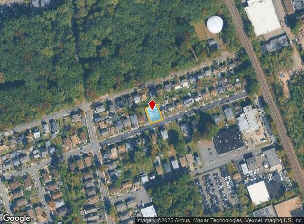
Property Record
385 Falmouth Ave, Elmwood Park, NJ 07407
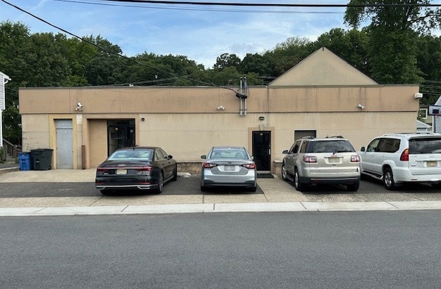

This Property Is For Sale
NEARBY LISTINGS FOR SALE OR LEASE
Property Detail
385 Falmouth Ave
11-00802-0000-00029
75 X 100
Industrialgeneral
Bergen
X
New Jersey
34003C0186H
29
2024
0.17 AC
2025
Route 46 Corridor
011400
Northern New Jersey
1,992 SF
New York-Jersey City-White Plains, NY-NJ
DEMOGRAPHICS near 385 Falmouth Ave
1 Mile
3 Mile
5 Mile
2024 Total Population
22,533
248,138
638,773
2029 Population
22,156
239,666
622,325
Pop Growth 2024-2029
(1.67%)
(3.41%)
(2.57%)
Average Age
41
39
39
2024 Total Households
7,988
83,543
219,213
HH Growth 2024-2029
(1.69%)
(3.51%)
(2.59%)
Median Household Inc
$92,826
$69,634
$76,249
Avg Household Size
2.80
2.90
2.80
2024 Avg HH Vehicles
2.00
2.00
2.00
Median Home Value
$444,581
$425,472
$451,118
Median Year Built
1956
1952
1954
Nearby Places
Map Layers
Map Styles
 Street
 Aerial
- Restaurants
- Banks
- Shops
- Fitness
- Groceries
PUBLIC TRANSPORTATION
COMMUTER RAIL
Broadway (Bergen County/Port Jervis Line - NJ Transit Commuter Rail (NJ Transit))
DRIVE
WALK
Distance
Broadway (Bergen County/Port Jervis Line - NJ Transit Commuter Rail (NJ Transit))
3 min
17 min
0.9 mi
Plauderville (Bergen County/Port Jervis Line - NJ Transit Commuter Rail (NJ Transit))
DRIVE
WALK
Distance
Plauderville (Bergen County/Port Jervis Line - NJ Transit Commuter Rail (NJ Transit))
6 min
2.3 mi
AIRPORT
Newark Liberty International
DRIVE
WALK
Distance
Newark Liberty International
27 min
21.1 mi
LaGuardia
DRIVE
WALK
Distance
LaGuardia
35 min
22.2 mi
Westchester County
DRIVE
WALK
Distance
Westchester County
56 min
38.0 mi
Freight Ports
Port Newark Container Terminal
DRIVE
WALK
Distance
Port Newark Container Terminal
31 min
20.3 mi
Nearby Properties
Address
Land Use
TOTAL SIZE
Lot Size
Zoning
Address
Land Use
TOTAL SIZE
Lot Size
Zoning
Address
Land Use
TOTAL SIZE
Lot Size
Zoning
136.31 AC
Address
Land Use
TOTAL SIZE
Lot Size
Zoning
988,414 SF
34.89 AC
BG
Address
Land Use
TOTAL SIZE
Lot Size
Zoning
466,866 SF
154.93 AC
R150
Address
Land Use
TOTAL SIZE
Lot Size
Zoning
8.75 AC
Address
Land Use
TOTAL SIZE
Lot Size
Zoning
378,400 SF
39.30 AC
BML
Address
Land Use
TOTAL SIZE
Lot Size
Zoning
7.10 AC
R-3
Address
Land Use
TOTAL SIZE
Lot Size
Zoning
160,036 SF
21.93 AC
R75
Address
Land Use
TOTAL SIZE
Lot Size
Zoning
7,060 SF
115.84 AC
HP
Address
Land Use
TOTAL SIZE
Lot Size
Zoning
8.66 AC
CH1
Address
Land Use
TOTAL SIZE
Lot Size
Zoning
197,742 SF
6.20 AC
R3
Address
Land Use
TOTAL SIZE
Lot Size
Zoning
250,833 SF
13.49 AC
BG
Address
Land Use
TOTAL SIZE
Lot Size
Zoning
341,076 SF
40.02 AC
R100
Address
Land Use
TOTAL SIZE
Lot Size
Zoning
259,273 SF
19.77 AC
BIL
Address
Land Use
TOTAL SIZE
Lot Size
Zoning
12,268 SF
98 AC
CR
Address
Land Use
TOTAL SIZE
Lot Size
Zoning
79,310 SF
2 AC
B-2
Address
Land Use
TOTAL SIZE
Lot Size
Zoning
25.50 AC
B2
Address
Land Use
TOTAL SIZE
Lot Size
Zoning
26,816 SF
25.50 AC
POP
Address
Land Use
TOTAL SIZE
Lot Size
Zoning
242,048 SF
25.40 AC
BLL
Address
Land Use
TOTAL SIZE
Lot Size
Zoning
9.96 AC
MU
Address
Land Use
TOTAL SIZE
Lot Size
Zoning
Address
Land Use
TOTAL SIZE
Lot Size
Zoning
286,500 SF
26.90 AC
LL
Address
Land Use
TOTAL SIZE
Lot Size
Zoning
152,050 SF
1.96 AC
B-1
Address
Land Use
TOTAL SIZE
Lot Size
Zoning
57,680 SF
20.01 AC
CR
Address
Land Use
TOTAL SIZE
Lot Size
Zoning
7.83 AC
Address
Land Use
TOTAL SIZE
Lot Size
Zoning
5.40 AC
RB
Address
Land Use
TOTAL SIZE
Lot Size
Zoning
Address
Land Use
TOTAL SIZE
Lot Size
Zoning
116,670 SF
13.79 AC
BIL
Address
Land Use
TOTAL SIZE
Lot Size
Zoning
1.80 AC
Address
Land Use
TOTAL SIZE
Lot Size
Zoning
824,024 SF
39.71 AC
I1
The World's #1 Commercial Real Estate Marketplace
Connect with us
© 2025 CoStar Group
The information above has been obtained from sources believed reliable. While we do not doubt its accuracy we have not verified it and make no guarantee, warranty or representation about it. It is your responsibility to independently confirm its accuracy and completeness. Any projections, opinions, assumptions, or estimates used are for example only and do not represent the current or future performance of the property. The value of this transaction to you depends on tax and other factors which should be evaluated by your tax, financial, and legal advisors. You and your advisors should conduct a careful, independent investigation of the property to determine to your satisfaction the suitability of the property for your needs.