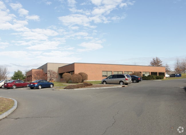
Property Record
385 Jordan Rd, Troy, NY 12180


Current Lease Availabilities
NEARBY LISTINGS FOR SALE OR LEASE
Property Detail
385 Jordan Rd
Albany-Schenectady-Troy, NY
MULTI TENANT # 8 1990/115
3200-122-1-4.19
Rensselaer
Professionalbldglegalinsurancerealestateetc
New York
ARE
4.019
36083C0237D
3.39 AC
2025
Outer Rensselaer County
2024
Albany/Schenectady/Troy
052301
DEMOGRAPHICS near 385 Jordan Rd
1 Mile
3 Mile
5 Mile
2024 Total Population
1,742
47,673
181,049
2029 Population
1,772
47,198
179,009
Pop Growth 2024-2029
+ 1.72%
(1.00%)
(1.13%)
Average Age
44
40
38
2024 Total Households
799
20,474
77,234
HH Growth 2024-2029
+ 1.63%
(1.04%)
(1.17%)
Median Household Inc
$87,589
$70,255
$59,616
Avg Household Size
2.10
2.20
2.10
2024 Avg HH Vehicles
2.00
1.00
1.00
Median Home Value
$260,179
$216,269
$223,637
Median Year Built
1994
1965
1955
Nearby Places
Map Layers
Map Styles
 Street
 Aerial
- Restaurants
- Banks
- Shops
- Fitness
- Groceries
PUBLIC TRANSPORTATION
COMMUTER RAIL
DRIVE
WALK
Distance
12 min
5.8 mi
AIRPORT
Albany International
DRIVE
WALK
Distance
Albany International
23 min
13.1 mi
Freight Ports
Albany, NY Port
DRIVE
WALK
Distance
Albany, NY Port
16 min
8.4 mi
Nearby Properties
Address
Land Use
TOTAL SIZE
Lot Size
Zoning
Address
Land Use
TOTAL SIZE
Lot Size
Zoning
120,579 SF
49.20 AC
CI
Address
Land Use
TOTAL SIZE
Lot Size
Zoning
207.50 AC
CM
Address
Land Use
TOTAL SIZE
Lot Size
Zoning
326,350 SF
11.11 AC
I
Address
Land Use
TOTAL SIZE
Lot Size
Zoning
199,495 SF
5.40 AC
CO
Address
Land Use
TOTAL SIZE
Lot Size
Zoning
11,900 SF
28.60 AC
86
Address
Land Use
TOTAL SIZE
Lot Size
Zoning
3,214 SF
412.83 AC
18
Address
Land Use
TOTAL SIZE
Lot Size
Zoning
220,480 SF
8.40 AC
M1
Address
Land Use
TOTAL SIZE
Lot Size
Zoning
11,264 SF
34.83 AC
MF
Address
Land Use
TOTAL SIZE
Lot Size
Zoning
7.10 AC
CO
Address
Land Use
TOTAL SIZE
Lot Size
Zoning
85.40 AC
M1
Address
Land Use
TOTAL SIZE
Lot Size
Zoning
19,274 SF
24.80 AC
84
Address
Land Use
TOTAL SIZE
Lot Size
Zoning
204,692 SF
30.97 AC
OC
Address
Land Use
TOTAL SIZE
Lot Size
Zoning
64,600 SF
13.16 AC
Address
Land Use
TOTAL SIZE
Lot Size
Zoning
90,174 SF
3.06 AC
R4
Address
Land Use
TOTAL SIZE
Lot Size
Zoning
131,937 SF
17.50 AC
R3A
Address
Land Use
TOTAL SIZE
Lot Size
Zoning
2,428 SF
23.10 AC
R3A
Address
Land Use
TOTAL SIZE
Lot Size
Zoning
63,992 SF
20 AC
CM
Address
Land Use
TOTAL SIZE
Lot Size
Zoning
34.12 AC
Address
Land Use
TOTAL SIZE
Lot Size
Zoning
1,465 SF
49.86 AC
OS
Address
Land Use
TOTAL SIZE
Lot Size
Zoning
7,240 SF
18.70 AC
M1
Address
Land Use
TOTAL SIZE
Lot Size
Zoning
1,536 SF
11.20 AC
M1
Address
Land Use
TOTAL SIZE
Lot Size
Zoning
8,528 SF
9.30 AC
R3A
Address
Land Use
TOTAL SIZE
Lot Size
Zoning
120,000 SF
11.77 AC
OC
Address
Land Use
TOTAL SIZE
Lot Size
Zoning
3,168 SF
21.70 AC
78
Address
Land Use
TOTAL SIZE
Lot Size
Zoning
104,851 SF
1.40 AC
C3
Address
Land Use
TOTAL SIZE
Lot Size
Zoning
105,094 SF
3.38 AC
MF
Address
Land Use
TOTAL SIZE
Lot Size
Zoning
32,000 SF
7.77 AC
M1
Address
Land Use
TOTAL SIZE
Lot Size
Zoning
69,286 SF
8.80 AC
R4
Address
Land Use
TOTAL SIZE
Lot Size
Zoning
136,218 SF
15.39 AC
CC
The World's #1 Commercial Real Estate Marketplace
Connect with us
© 2026 CoStar Group
The information above has been obtained from sources believed reliable. While we do not doubt its accuracy we have not verified it and make no guarantee, warranty or representation about it. It is your responsibility to independently confirm its accuracy and completeness. Any projections, opinions, assumptions, or estimates used are for example only and do not represent the current or future performance of the property. The value of this transaction to you depends on tax and other factors which should be evaluated by your tax, financial, and legal advisors. You and your advisors should conduct a careful, independent investigation of the property to determine to your satisfaction the suitability of the property for your needs.