Property Record
385 Route 9 W, Alpine, NJ 07620
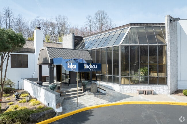


This Property Is For Sale
Property Detail
385 Route 9 W
02-00090-0000-00007
2.730 AC
Commercialnec
BERGEN
RA
New Jersey
B and X Area of moderate flood hazard, usually the area between the limits of the 100-year and 500-year floods.
7
2024
2.73 AC
2025
Palisades
002100
Northern New Jersey
726 SF
New York-Jersey City-White Plains, NY-NJ
NEARBY LISTINGS FOR SALE OR LEASE
DEMOGRAPHICS near 385 Route 9 W
1 mile
3 mile
5 mile
2025 Total Population
46
97,301
346,625
2030 Population
48
98,744
351,572
Pop Growth 2025-2030
+ 4.35%
+ 1.48%
+ 1.43%
Average Age
45
41
42
2025 Total Households
15
36,338
126,238
HH Growth 2025-2030
+ 6.67%
+ 1.39%
+ 1.32%
Median Household Inc
$244,444
$92,847
$106,277
Avg Household Size
2.90
2.50
2.60
2025 Avg HH Vehicles
2.00
1.00
1.00
Median Home Value
$1,137,500
$682,046
$666,006
Median Year Built
1981
1961
1957
Nearby Places
Map Layers
Map Styles
 Street
 Aerial
Layers
 Traffic
 Biking
Places
Listings with unknown addresses are not visible on the map
- Restaurants
- Banks
- Shops
- Fitness
- Groceries
PUBLIC TRANSPORTATION
AIRPORT
LaGuardia
Drive
Walk
Distance
LaGuardia
35 min
20.4 mi
Westchester County
Drive
Walk
Distance
Westchester County
38 min
25.8 mi
Newark Liberty International
Drive
Walk
Distance
Newark Liberty International
35 min
27.6 mi
Freight Ports
NY - Red Hook Container Terminal
Drive
Walk
Distance
NY - Red Hook Container Terminal
47 min
27.1 mi
Nearby Properties
Address
Land Use
TOTAL SIZE
Lot Size
Zoning
Address
Land Use
TOTAL SIZE
Lot Size
Zoning
1,125 SF
542.62 AC
RA
Address
Land Use
TOTAL SIZE
Lot Size
Zoning
689 SF
423.72 AC
P
Address
Land Use
TOTAL SIZE
Lot Size
Zoning
289.02 AC
P
Address
Land Use
TOTAL SIZE
Lot Size
Zoning
229.55 AC
P
Address
Land Use
TOTAL SIZE
Lot Size
Zoning
185.35 AC
P
Address
Land Use
TOTAL SIZE
Lot Size
Zoning
166.61 AC
P
Address
Land Use
TOTAL SIZE
Lot Size
Zoning
4,000 SF
14.69 AC
Address
Land Use
TOTAL SIZE
Lot Size
Zoning
23.97 AC
Address
Land Use
TOTAL SIZE
Lot Size
Zoning
134.16 AC
RA
Address
Land Use
TOTAL SIZE
Lot Size
Zoning
97,600 SF
136.28 AC
R-40
Address
Land Use
TOTAL SIZE
Lot Size
Zoning
94.42 AC
P
Address
Land Use
TOTAL SIZE
Lot Size
Zoning
Address
Land Use
TOTAL SIZE
Lot Size
Zoning
163.19 AC
Address
Land Use
TOTAL SIZE
Lot Size
Zoning
Address
Land Use
TOTAL SIZE
Lot Size
Zoning
8.08 AC
C
Address
Land Use
TOTAL SIZE
Lot Size
Zoning
54.65 AC
P
Address
Land Use
TOTAL SIZE
Lot Size
Zoning
28.77 AC
Address
Land Use
TOTAL SIZE
Lot Size
Zoning
15,828 SF
17.71 AC
Address
Land Use
TOTAL SIZE
Lot Size
Zoning
47.14 AC
P
Address
Land Use
TOTAL SIZE
Lot Size
Zoning
6.72 AC
C
Address
Land Use
TOTAL SIZE
Lot Size
Zoning
48.19 AC
P
Address
Land Use
TOTAL SIZE
Lot Size
Zoning
15.23 AC
C
Address
Land Use
TOTAL SIZE
Lot Size
Zoning
41.23 AC
P
Address
Land Use
TOTAL SIZE
Lot Size
Zoning
13.35 AC
Address
Land Use
TOTAL SIZE
Lot Size
Zoning
40.47 AC
DISTRICTN
Address
Land Use
TOTAL SIZE
Lot Size
Zoning
Address
Land Use
TOTAL SIZE
Lot Size
Zoning
4,938 SF
119 AC
Address
Land Use
TOTAL SIZE
Lot Size
Zoning
30.29 AC
P
Address
Land Use
TOTAL SIZE
Lot Size
Zoning
161.33 AC
P
Address
Land Use
TOTAL SIZE
Lot Size
Zoning
69.90 AC
R-20
The World's #1 Commercial Real Estate Marketplace
Connect with us
© 2026 CoStar Group
The information above has been obtained from sources believed reliable. While we do not doubt its accuracy we have not verified it and make no guarantee, warranty or representation about it. It is your responsibility to independently confirm its accuracy and completeness. Any projections, opinions, assumptions, or estimates used are for example only and do not represent the current or future performance of the property. The value of this transaction to you depends on tax and other factors which should be evaluated by your tax, financial, and legal advisors. You and your advisors should conduct a careful, independent investigation of the property to determine to your satisfaction the suitability of the property for your needs.