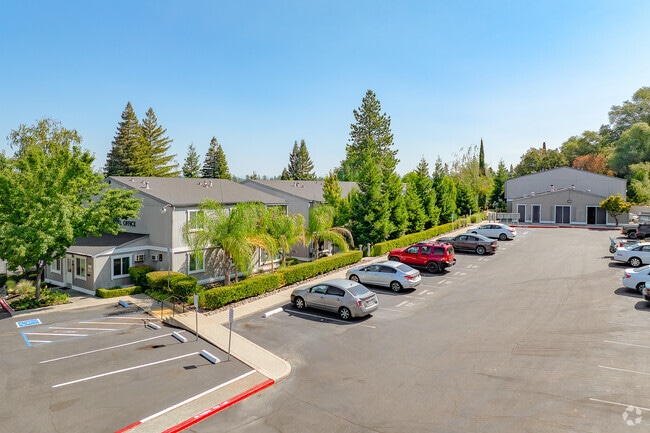
Property Record
385 Sacramento St, Auburn, CA 95603


NEARBY LISTINGS FOR SALE OR LEASE
-
-
View all Auburn listings for sale on LoopNet.com
Property Detail
385 Sacramento St
004-310-037
2.5 A FR SEC 15 12 8
Apartment
Placer
X
California
06061C0764H
2.50 AC
2024
Outlying Placer County
2025
Sacramento
020402
Sacramento--Roseville--Arden-Arcade, CA
36,432 SF
DEMOGRAPHICS near 385 Sacramento St
1 Mile
3 Mile
5 Mile
2024 Total Population
4,922
20,051
38,770
2029 Population
5,277
21,525
41,387
Pop Growth 2024-2029
+ 7.21%
+ 7.35%
+ 6.75%
Average Age
46
46
46
2024 Total Households
2,138
8,667
15,937
HH Growth 2024-2029
+ 7.34%
+ 7.48%
+ 6.88%
Median Household Inc
$81,127
$81,827
$87,196
Avg Household Size
2.30
2.30
2.30
2024 Avg HH Vehicles
2.00
2.00
2.00
Median Home Value
$691,737
$657,045
$619,693
Median Year Built
1975
1977
1979
Nearby Places
Map Layers
Map Styles
 Street
 Aerial
- Restaurants
- Banks
- Shops
- Fitness
- Groceries
PUBLIC TRANSPORTATION
COMMUTER RAIL
Auburn-Conheim (Capitol Corridor - Capitol Corridor Joint Powers Authority)
DRIVE
WALK
Distance
Auburn-Conheim (Capitol Corridor - Capitol Corridor Joint Powers Authority)
4 min
1.7 mi
Auburn Amtrak (Capitol Corridor - Amtrak)
DRIVE
WALK
Distance
Auburn Amtrak (Capitol Corridor - Amtrak)
4 min
1.7 mi
Freight Ports
Port of Stockton
DRIVE
WALK
Distance
Port of Stockton
95 min
81.1 mi
Nearby Properties
Address
Land Use
TOTAL SIZE
Lot Size
Zoning
Address
Land Use
TOTAL SIZE
Lot Size
Zoning
43,785 SF
3.80 AC
Address
Land Use
TOTAL SIZE
Lot Size
Zoning
124,714 SF
7.90 AC
Address
Land Use
TOTAL SIZE
Lot Size
Zoning
97,458 SF
7.90 AC
HSDC
Address
Land Use
TOTAL SIZE
Lot Size
Zoning
55,721 SF
3.10 AC
Address
Land Use
TOTAL SIZE
Lot Size
Zoning
52,100 SF
2.30 AC
Address
Land Use
TOTAL SIZE
Lot Size
Zoning
49,023 SF
0.89 AC
Address
Land Use
TOTAL SIZE
Lot Size
Zoning
37,259 SF
5.80 AC
Address
Land Use
TOTAL SIZE
Lot Size
Zoning
49,000 SF
2 AC
Address
Land Use
TOTAL SIZE
Lot Size
Zoning
50,450 SF
2.60 AC
Address
Land Use
TOTAL SIZE
Lot Size
Zoning
65,550 SF
5.70 AC
Address
Land Use
TOTAL SIZE
Lot Size
Zoning
35,418 SF
2.70 AC
Address
Land Use
TOTAL SIZE
Lot Size
Zoning
44,800 SF
4.10 AC
Address
Land Use
TOTAL SIZE
Lot Size
Zoning
38,448 SF
2.40 AC
Address
Land Use
TOTAL SIZE
Lot Size
Zoning
26,064 SF
1.60 AC
Address
Land Use
TOTAL SIZE
Lot Size
Zoning
1 SF
2.10 AC
HSDC
Address
Land Use
TOTAL SIZE
Lot Size
Zoning
23,426 SF
2.40 AC
Address
Land Use
TOTAL SIZE
Lot Size
Zoning
54,476 SF
7.82 AC
Address
Land Use
TOTAL SIZE
Lot Size
Zoning
30,419 SF
3 AC
Address
Land Use
TOTAL SIZE
Lot Size
Zoning
63,378 SF
30.30 AC
Address
Land Use
TOTAL SIZE
Lot Size
Zoning
32,396 SF
5.83 AC
Address
Land Use
TOTAL SIZE
Lot Size
Zoning
39,328 SF
5.07 AC
Address
Land Use
TOTAL SIZE
Lot Size
Zoning
28,256 SF
2.80 AC
Address
Land Use
TOTAL SIZE
Lot Size
Zoning
20,710 SF
1.50 AC
Address
Land Use
TOTAL SIZE
Lot Size
Zoning
19,726 SF
1.21 AC
Address
Land Use
TOTAL SIZE
Lot Size
Zoning
29,489 SF
2.20 AC
HSDC
Address
Land Use
TOTAL SIZE
Lot Size
Zoning
18,980 SF
0.37 AC
Address
Land Use
TOTAL SIZE
Lot Size
Zoning
34,536 SF
3 AC
Address
Land Use
TOTAL SIZE
Lot Size
Zoning
37,038 SF
2.80 AC
Address
Land Use
TOTAL SIZE
Lot Size
Zoning
186.30 AC
FBX
The World's #1 Commercial Real Estate Marketplace
Connect with us
© 2026 CoStar Group
The information above has been obtained from sources believed reliable. While we do not doubt its accuracy we have not verified it and make no guarantee, warranty or representation about it. It is your responsibility to independently confirm its accuracy and completeness. Any projections, opinions, assumptions, or estimates used are for example only and do not represent the current or future performance of the property. The value of this transaction to you depends on tax and other factors which should be evaluated by your tax, financial, and legal advisors. You and your advisors should conduct a careful, independent investigation of the property to determine to your satisfaction the suitability of the property for your needs.