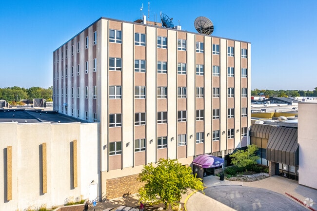
Property Record
3850 Merle Hay Rd, Des Moines, IA 50310
This Property Is For Sale
NEARBY LISTINGS FOR SALE OR LEASE
Property Detail
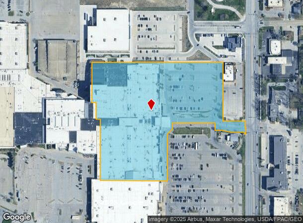
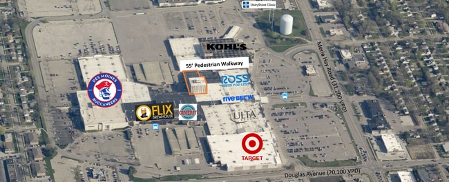
3850 Merle Hay Rd
Des Moines-West Des Moines, IA
Merle Hay-Aurora Place
100-09472001012
-EX PARCEL A BOOK 7047 PAGE 429- PARCEL L BOOK 11159 PAGE 79 LOT 1 MERLE HAY-AURORA PL
Regionalshoppingcenterormallwithanchorstore
Polk
X
Iowa
19153C0189F
1
2024
9.62 AC
2025
Western Suburbs
000801
Des Moines
386,236 SF
DEMOGRAPHICS near 3850 Merle Hay Rd
1 Mile
3 Mile
5 Mile
2024 Total Population
12,796
85,791
188,790
2029 Population
13,148
88,407
195,530
Pop Growth 2024-2029
+ 2.75%
+ 3.05%
+ 3.57%
Average Age
38
39
39
2024 Total Households
5,425
35,866
79,407
HH Growth 2024-2029
+ 2.95%
+ 3.22%
+ 3.78%
Median Household Inc
$63,933
$72,111
$69,265
Avg Household Size
2.30
2.30
2.30
2024 Avg HH Vehicles
2.00
2.00
2.00
Median Home Value
$176,918
$213,822
$219,197
Median Year Built
1963
1967
1970
Nearby Places
Map Layers
Map Styles
 Street
 Aerial
- Restaurants
- Banks
- Shops
- Fitness
- Groceries
PUBLIC TRANSPORTATION
AIRPORT
Des Moines International
DRIVE
WALK
Distance
Des Moines International
19 min
9.2 mi
Freight Ports
Port Milwaukee
DRIVE
WALK
Distance
Port Milwaukee
418 min
375.5 mi
Nearby Properties
Address
Land Use
TOTAL SIZE
Lot Size
Zoning
Address
Land Use
TOTAL SIZE
Lot Size
Zoning
627,104 SF
40.09 AC
Address
Land Use
TOTAL SIZE
Lot Size
Zoning
255,521 SF
60.90 AC
RE
Address
Land Use
TOTAL SIZE
Lot Size
Zoning
415,320 SF
51.16 AC
PUD
Address
Land Use
TOTAL SIZE
Lot Size
Zoning
179,663 SF
2.27 AC
PUD
Address
Land Use
TOTAL SIZE
Lot Size
Zoning
307,734 SF
23.59 AC
R-3
Address
Land Use
TOTAL SIZE
Lot Size
Zoning
71,938 SF
8.23 AC
C-O
Address
Land Use
TOTAL SIZE
Lot Size
Zoning
101,592 SF
7.79 AC
PUD
Address
Land Use
TOTAL SIZE
Lot Size
Zoning
117,272 SF
3.46 AC
R1-60
Address
Land Use
TOTAL SIZE
Lot Size
Zoning
141,377 SF
3.16 AC
Address
Land Use
TOTAL SIZE
Lot Size
Zoning
247,414 SF
15.83 AC
RH
Address
Land Use
TOTAL SIZE
Lot Size
Zoning
374,551 SF
9.37 AC
R-3
Address
Land Use
TOTAL SIZE
Lot Size
Zoning
166,908 SF
8.03 AC
R-3
Address
Land Use
TOTAL SIZE
Lot Size
Zoning
188,453 SF
14.20 AC
R-3
Address
Land Use
TOTAL SIZE
Lot Size
Zoning
110,637 SF
11.05 AC
R-3
Address
Land Use
TOTAL SIZE
Lot Size
Zoning
125,396 SF
12.89 AC
PUD
Address
Land Use
TOTAL SIZE
Lot Size
Zoning
146,025 SF
9.59 AC
PUD
Address
Land Use
TOTAL SIZE
Lot Size
Zoning
258,178 SF
5.95 AC
Address
Land Use
TOTAL SIZE
Lot Size
Zoning
91,985 SF
13.11 AC
PUD
Address
Land Use
TOTAL SIZE
Lot Size
Zoning
223,876 SF
15.01 AC
Address
Land Use
TOTAL SIZE
Lot Size
Zoning
143,831 SF
16.12 AC
PUD
Address
Land Use
TOTAL SIZE
Lot Size
Zoning
95,039 SF
4.52 AC
PUD
Address
Land Use
TOTAL SIZE
Lot Size
Zoning
120,808 SF
4.41 AC
PUD
Address
Land Use
TOTAL SIZE
Lot Size
Zoning
112,472 SF
7.48 AC
R-3
Address
Land Use
TOTAL SIZE
Lot Size
Zoning
94,467 SF
8.13 AC
PUD
Address
Land Use
TOTAL SIZE
Lot Size
Zoning
56,478 SF
5.86 AC
Address
Land Use
TOTAL SIZE
Lot Size
Zoning
158,256 SF
8.87 AC
R-3
Address
Land Use
TOTAL SIZE
Lot Size
Zoning
130,136 SF
6.77 AC
PARKVIEW P
Address
Land Use
TOTAL SIZE
Lot Size
Zoning
78,390 SF
3.04 AC
R1-80
The World's #1 Commercial Real Estate Marketplace
Connect with us
© 2026 CoStar Group
The information above has been obtained from sources believed reliable. While we do not doubt its accuracy we have not verified it and make no guarantee, warranty or representation about it. It is your responsibility to independently confirm its accuracy and completeness. Any projections, opinions, assumptions, or estimates used are for example only and do not represent the current or future performance of the property. The value of this transaction to you depends on tax and other factors which should be evaluated by your tax, financial, and legal advisors. You and your advisors should conduct a careful, independent investigation of the property to determine to your satisfaction the suitability of the property for your needs.