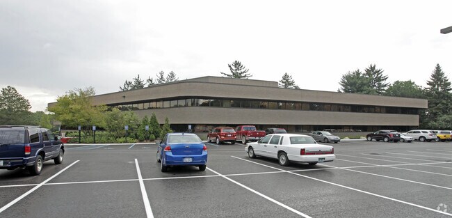
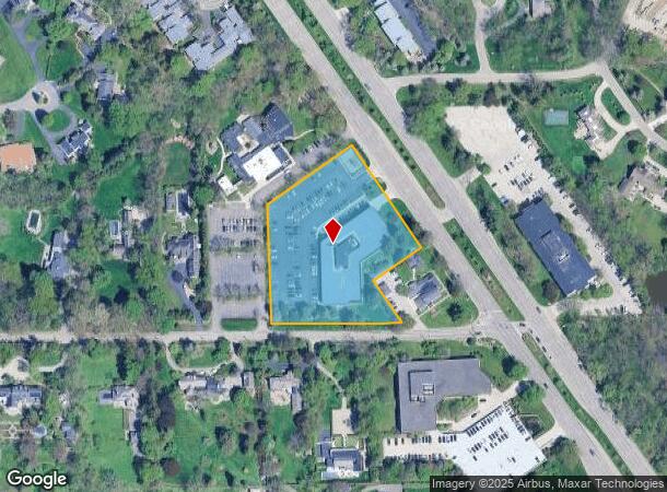
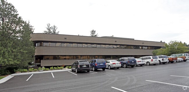
Property Record
38525 Woodward Ave, Bloomfield Hills, MI 48304

NEARBY LISTINGS FOR SALE OR LEASE
Property Detail
38525 Woodward Ave
Detroit-Warren-Dearborn, MI
Assessors Plat No 6
19-23-251-024
T2N, R10E, SEC 23 ASSESSOR'S PLAT NO 6 PART OF LOT 29 BEG AT SW LOT COR, TH S 89-58-00 E 291.17 FT, TH N 87-24-20 E 55.70 FT,
Officebuilding
Oakland
X
Michigan
26125C0528F
29
2024
3 AC
2025
Bloomfield
152000
Detroit
50,894 SF
DEMOGRAPHICS near 38525 Woodward Ave
1 Mile
3 Mile
5 Mile
2024 Total Population
4,044
67,439
193,175
2029 Population
4,036
66,943
191,948
Pop Growth 2024-2029
(0.20%)
(0.74%)
(0.64%)
Average Age
45
43
43
2024 Total Households
1,431
26,555
80,079
HH Growth 2024-2029
(0.28%)
(0.71%)
(0.64%)
Median Household Inc
$212,435
$152,617
$107,427
Avg Household Size
2.60
2.50
2.40
2024 Avg HH Vehicles
2.00
2.00
2.00
Median Home Value
$825,892
$595,481
$401,652
Median Year Built
1963
1965
1967
Nearby Places
Map Layers
Map Styles
 Street
 Aerial
- Restaurants
- Banks
- Shops
- Fitness
- Groceries
PUBLIC TRANSPORTATION
COMMUTER RAIL
Troy Amtrak Station (Wolverine - Amtrak)
DRIVE
WALK
Distance
Troy Amtrak Station (Wolverine - Amtrak)
8 min
3.5 mi
Pontiac Amtrak Station (Wolverine - Amtrak)
DRIVE
WALK
Distance
Pontiac Amtrak Station (Wolverine - Amtrak)
11 min
6.0 mi
AIRPORT
Detroit Metro Wayne County
DRIVE
WALK
Distance
Detroit Metro Wayne County
53 min
32.4 mi
Windsor International
DRIVE
WALK
Distance
Windsor International
53 min
32.7 mi
Freight Ports
Port of Toledo
DRIVE
WALK
Distance
Port of Toledo
102 min
74.4 mi
Nearby Properties
Address
Land Use
TOTAL SIZE
Lot Size
Zoning
Address
Land Use
TOTAL SIZE
Lot Size
Zoning
399,735 SF
19.71 AC
B2
Address
Land Use
TOTAL SIZE
Lot Size
Zoning
224,766 SF
19.92 AC
B2
Address
Land Use
TOTAL SIZE
Lot Size
Zoning
111,030 SF
0.97 AC
BI
Address
Land Use
TOTAL SIZE
Lot Size
Zoning
149,395 SF
1.02 AC
BI
Address
Land Use
TOTAL SIZE
Lot Size
Zoning
208,296 SF
8.16 AC
OSC
Address
Land Use
TOTAL SIZE
Lot Size
Zoning
143,160 SF
0.84 AC
BI
Address
Land Use
TOTAL SIZE
Lot Size
Zoning
236,140 SF
1.67 AC
BI
Address
Land Use
TOTAL SIZE
Lot Size
Zoning
99,661 SF
0.62 AC
Address
Land Use
TOTAL SIZE
Lot Size
Zoning
427,945 SF
18.26 AC
OSC
Address
Land Use
TOTAL SIZE
Lot Size
Zoning
160,796 SF
1.84 AC
Address
Land Use
TOTAL SIZE
Lot Size
Zoning
365,104 SF
2.03 AC
Address
Land Use
TOTAL SIZE
Lot Size
Zoning
301,728 SF
2.83 AC
B2
Address
Land Use
TOTAL SIZE
Lot Size
Zoning
119,732 SF
3.77 AC
Address
Land Use
TOTAL SIZE
Lot Size
Zoning
289,110 SF
6.07 AC
BI
Address
Land Use
TOTAL SIZE
Lot Size
Zoning
83,244 SF
0.38 AC
Address
Land Use
TOTAL SIZE
Lot Size
Zoning
206,590 SF
6.14 AC
RI
Address
Land Use
TOTAL SIZE
Lot Size
Zoning
203,643 SF
9.85 AC
IV
Address
Land Use
TOTAL SIZE
Lot Size
Zoning
242,512 SF
6.60 AC
BI
Address
Land Use
TOTAL SIZE
Lot Size
Zoning
96,774 SF
6.34 AC
BI
Address
Land Use
TOTAL SIZE
Lot Size
Zoning
154,370 SF
8.80 AC
BI
Address
Land Use
TOTAL SIZE
Lot Size
Zoning
218,023 SF
21.80 AC
AI
Address
Land Use
TOTAL SIZE
Lot Size
Zoning
84,711 SF
5.05 AC
BI
Address
Land Use
TOTAL SIZE
Lot Size
Zoning
225,890 SF
10.10 AC
OM
Address
Land Use
TOTAL SIZE
Lot Size
Zoning
80,334 SF
0.57 AC
BI
Address
Land Use
TOTAL SIZE
Lot Size
Zoning
267,393 SF
11.11 AC
BI
Address
Land Use
TOTAL SIZE
Lot Size
Zoning
79,935 SF
1.02 AC
BI
Address
Land Use
TOTAL SIZE
Lot Size
Zoning
109,570 SF
0.68 AC
BI
Address
Land Use
TOTAL SIZE
Lot Size
Zoning
245,740 SF
1.06 AC
BI
Address
Land Use
TOTAL SIZE
Lot Size
Zoning
72,029 SF
0.57 AC
BV
Address
Land Use
TOTAL SIZE
Lot Size
Zoning
56,867 SF
3.80 AC
BI
The World's #1 Commercial Real Estate Marketplace
Connect with us
© 2026 CoStar Group
The information above has been obtained from sources believed reliable. While we do not doubt its accuracy we have not verified it and make no guarantee, warranty or representation about it. It is your responsibility to independently confirm its accuracy and completeness. Any projections, opinions, assumptions, or estimates used are for example only and do not represent the current or future performance of the property. The value of this transaction to you depends on tax and other factors which should be evaluated by your tax, financial, and legal advisors. You and your advisors should conduct a careful, independent investigation of the property to determine to your satisfaction the suitability of the property for your needs.