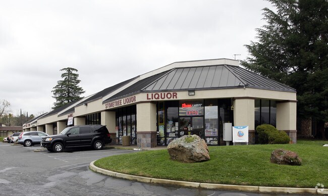
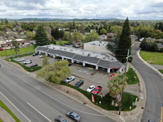
Property Record
3853 Taylor Rd, Loomis, CA 95650


NEARBY LISTINGS FOR SALE OR LEASE
Property Detail
3853 Taylor Rd
044-141-039
33-52, Parcel Map
Storemultistory
PAR 1 PMOR 33-52
X
Placer
06061C0954H
California
2024
0.89 AC
2025
Auburn/Loomis
021203
Sacramento
13,031 SF
Sacramento-Roseville-Folsom, CA
DEMOGRAPHICS near 3853 Taylor Rd
1 Mile
3 Mile
5 Mile
2024 Total Population
4,921
32,928
121,287
2029 Population
5,228
35,322
130,343
Pop Growth 2024-2029
+ 6.24%
+ 7.27%
+ 7.47%
Average Age
41
42
41
2024 Total Households
1,761
12,080
44,318
HH Growth 2024-2029
+ 6.36%
+ 7.40%
+ 7.48%
Median Household Inc
$94,822
$111,400
$115,054
Avg Household Size
2.80
2.70
2.70
2024 Avg HH Vehicles
2.00
2.00
2.00
Median Home Value
$736,601
$724,889
$727,369
Median Year Built
1982
1991
1998
Nearby Places
Map Layers
Map Styles
 Street
 Aerial
- Restaurants
- Banks
- Shops
- Fitness
- Groceries
PUBLIC TRANSPORTATION
COMMUTER RAIL
Rocklin Amtrak Station (Capitol Corridor - Amtrak)
DRIVE
WALK
Distance
Rocklin Amtrak Station (Capitol Corridor - Amtrak)
5 min
2.8 mi
Roseville (California Zephyr - Amtrak, Capitol Corridor - Amtrak)
DRIVE
WALK
Distance
Roseville (California Zephyr - Amtrak, Capitol Corridor - Amtrak)
13 min
7.5 mi
AIRPORT
Sacramento International
DRIVE
WALK
Distance
Sacramento International
41 min
31.0 mi
Freight Ports
Port of Stockton
DRIVE
WALK
Distance
Port of Stockton
83 min
71.2 mi
Nearby Properties
Address
Land Use
TOTAL SIZE
Lot Size
Zoning
Address
Land Use
TOTAL SIZE
Lot Size
Zoning
182,547 SF
10.19 AC
Address
Land Use
TOTAL SIZE
Lot Size
Zoning
246,349 SF
9.89 AC
Address
Land Use
TOTAL SIZE
Lot Size
Zoning
154,696 SF
10.80 AC
Address
Land Use
TOTAL SIZE
Lot Size
Zoning
194,087 SF
15.82 AC
Address
Land Use
TOTAL SIZE
Lot Size
Zoning
159,029 SF
17.62 AC
Address
Land Use
TOTAL SIZE
Lot Size
Zoning
136,101 SF
10 AC
Address
Land Use
TOTAL SIZE
Lot Size
Zoning
69,240 SF
4.10 AC
Address
Land Use
TOTAL SIZE
Lot Size
Zoning
1,992 SF
44.99 AC
RAB100
Address
Land Use
TOTAL SIZE
Lot Size
Zoning
73,756 SF
6.60 AC
Address
Land Use
TOTAL SIZE
Lot Size
Zoning
6,167 SF
12.20 AC
Address
Land Use
TOTAL SIZE
Lot Size
Zoning
100,348 SF
12.50 AC
Address
Land Use
TOTAL SIZE
Lot Size
Zoning
103,299 SF
9.60 AC
Address
Land Use
TOTAL SIZE
Lot Size
Zoning
39,055 SF
4.40 AC
Address
Land Use
TOTAL SIZE
Lot Size
Zoning
89,928 SF
6 AC
CG
Address
Land Use
TOTAL SIZE
Lot Size
Zoning
48,170 SF
4 AC
Address
Land Use
TOTAL SIZE
Lot Size
Zoning
63,608 SF
5.20 AC
CG
Address
Land Use
TOTAL SIZE
Lot Size
Zoning
44,050 SF
3.90 AC
Address
Land Use
TOTAL SIZE
Lot Size
Zoning
34,066 SF
2.90 AC
Address
Land Use
TOTAL SIZE
Lot Size
Zoning
35,132 SF
2.20 AC
Address
Land Use
TOTAL SIZE
Lot Size
Zoning
34,986 SF
2.26 AC
Address
Land Use
TOTAL SIZE
Lot Size
Zoning
29,380 SF
4.70 AC
Address
Land Use
TOTAL SIZE
Lot Size
Zoning
19,604 SF
3.08 AC
Address
Land Use
TOTAL SIZE
Lot Size
Zoning
85,435 SF
2.75 AC
Address
Land Use
TOTAL SIZE
Lot Size
Zoning
78,000 SF
1.60 AC
Address
Land Use
TOTAL SIZE
Lot Size
Zoning
20,800 SF
2.10 AC
Address
Land Use
TOTAL SIZE
Lot Size
Zoning
35,146 SF
4 AC
Address
Land Use
TOTAL SIZE
Lot Size
Zoning
49,312 SF
15.40 AC
Address
Land Use
TOTAL SIZE
Lot Size
Zoning
25,368 SF
1.08 AC
RH
Address
Land Use
TOTAL SIZE
Lot Size
Zoning
38,150 SF
2.90 AC
Address
Land Use
TOTAL SIZE
Lot Size
Zoning
16,429 SF
9.50 AC
The World's #1 Commercial Real Estate Marketplace
Connect with us
© 2026 CoStar Group
The information above has been obtained from sources believed reliable. While we do not doubt its accuracy we have not verified it and make no guarantee, warranty or representation about it. It is your responsibility to independently confirm its accuracy and completeness. Any projections, opinions, assumptions, or estimates used are for example only and do not represent the current or future performance of the property. The value of this transaction to you depends on tax and other factors which should be evaluated by your tax, financial, and legal advisors. You and your advisors should conduct a careful, independent investigation of the property to determine to your satisfaction the suitability of the property for your needs.