Property Record
38550 Chestnut Ridge Rd, Elyria, OH 44035

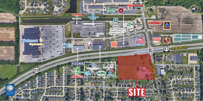
NEARBY LISTINGS FOR SALE OR LEASE
Property Detail
38550 Chestnut Ridge Rd
10-00-005-102-015
*NOTES ON ESMT*
Sfr
Lorain
X
Ohio
39093C0229D
1.48 AC
2024
Lorain County
2024
Cleveland
071202
Cleveland-Elyria, OH
1,978 SF
DEMOGRAPHICS near 38550 Chestnut Ridge Rd
1 mile
3 mile
5 mile
2024 Total Population
7,689
44,182
90,397
2029 Population
8,016
45,995
94,156
Pop Growth 2024-2029
+ 4.25%
+ 4.10%
+ 4.16%
Average Age
45
41
42
2024 Total Households
3,314
18,487
37,556
HH Growth 2024-2029
+ 4.22%
+ 4.05%
+ 4.15%
Median Household Inc
$64,720
$54,381
$59,031
Avg Household Size
2.30
2.30
2.30
2024 Avg HH Vehicles
2.00
2.00
2.00
Median Home Value
$174,831
$154,368
$167,535
Median Year Built
1991
1965
1970
Nearby Places
Map Layers
Map Styles
 Street
 Aerial
Transit
 Traffic
 Biking
Places
Listings with unknown addresses are not visible on the map
- Restaurants
- Banks
- Shops
- Fitness
- Groceries
PUBLIC TRANSPORTATION
COMMUTER RAIL
Elyria Amtrak (Capitol Limited - Amtrak, Lake Shore Limited - Amtrak)
Drive
Walk
Distance
Elyria Amtrak (Capitol Limited - Amtrak, Lake Shore Limited - Amtrak)
7 min
3.1 mi
AIRPORT
Cleveland-Hopkins International
Drive
Walk
Distance
Cleveland-Hopkins International
25 min
16.4 mi
Freight Ports
Port of Toledo
Drive
Walk
Distance
Port of Toledo
114 min
93.9 mi
SALE & LEASE HISTORY
LISTING DATE
SALE/LEASE

Sep 24, 2016
For Sale
Nearby Properties
Address
Land Use
TOTAL SIZE
Lot Size
Zoning
Address
Land Use
TOTAL SIZE
Lot Size
Zoning
427,871 SF
6.24 AC
Address
Land Use
TOTAL SIZE
Lot Size
Zoning
351,623 SF
3.13 AC
Address
Land Use
TOTAL SIZE
Lot Size
Zoning
199,200 SF
1.77 AC
Address
Land Use
TOTAL SIZE
Lot Size
Zoning
264,274 SF
15.03 AC
Address
Land Use
TOTAL SIZE
Lot Size
Zoning
155,964 SF
15.06 AC
Address
Land Use
TOTAL SIZE
Lot Size
Zoning
61,570 SF
0.20 AC
Address
Land Use
TOTAL SIZE
Lot Size
Zoning
150,180 SF
20.21 AC
Address
Land Use
TOTAL SIZE
Lot Size
Zoning
346,114 SF
37.97 AC
Address
Land Use
TOTAL SIZE
Lot Size
Zoning
68,786 SF
33.55 AC
Address
Land Use
TOTAL SIZE
Lot Size
Zoning
115,734 SF
29.86 AC
Address
Land Use
TOTAL SIZE
Lot Size
Zoning
107,576 SF
14.79 AC
Address
Land Use
TOTAL SIZE
Lot Size
Zoning
10,608 SF
76.77 AC
Address
Land Use
TOTAL SIZE
Lot Size
Zoning
206,128 SF
19.97 AC
Address
Land Use
TOTAL SIZE
Lot Size
Zoning
79,556 SF
17.55 AC
Address
Land Use
TOTAL SIZE
Lot Size
Zoning
106,938 SF
1.12 AC
Address
Land Use
TOTAL SIZE
Lot Size
Zoning
32,784 SF
0.25 AC
Address
Land Use
TOTAL SIZE
Lot Size
Zoning
126,448 SF
22.54 AC
Address
Land Use
TOTAL SIZE
Lot Size
Zoning
115,898 SF
8.67 AC
Address
Land Use
TOTAL SIZE
Lot Size
Zoning
158,510 SF
6.01 AC
Address
Land Use
TOTAL SIZE
Lot Size
Zoning
61,278 SF
8.25 AC
Address
Land Use
TOTAL SIZE
Lot Size
Zoning
40,000 SF
4.20 AC
Address
Land Use
TOTAL SIZE
Lot Size
Zoning
57,634 SF
4.73 AC
Address
Land Use
TOTAL SIZE
Lot Size
Zoning
151,565 SF
0.11 AC
Address
Land Use
TOTAL SIZE
Lot Size
Zoning
39,249 SF
0.74 AC
Address
Land Use
TOTAL SIZE
Lot Size
Zoning
76,610 SF
2.49 AC
Address
Land Use
TOTAL SIZE
Lot Size
Zoning
100,025 SF
9.06 AC
Address
Land Use
TOTAL SIZE
Lot Size
Zoning
141,945 SF
7.80 AC
Address
Land Use
TOTAL SIZE
Lot Size
Zoning
80,160 SF
4.67 AC
Address
Land Use
TOTAL SIZE
Lot Size
Zoning
106,325 SF
2.25 AC
Address
Land Use
TOTAL SIZE
Lot Size
Zoning
286,466 SF
19.67 AC
The World's #1 Commercial Real Estate Marketplace
Connect with us
© 2026 CoStar Group
The information above has been obtained from sources believed reliable. While we do not doubt its accuracy we have not verified it and make no guarantee, warranty or representation about it. It is your responsibility to independently confirm its accuracy and completeness. Any projections, opinions, assumptions, or estimates used are for example only and do not represent the current or future performance of the property. The value of this transaction to you depends on tax and other factors which should be evaluated by your tax, financial, and legal advisors. You and your advisors should conduct a careful, independent investigation of the property to determine to your satisfaction the suitability of the property for your needs.