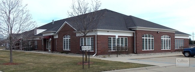
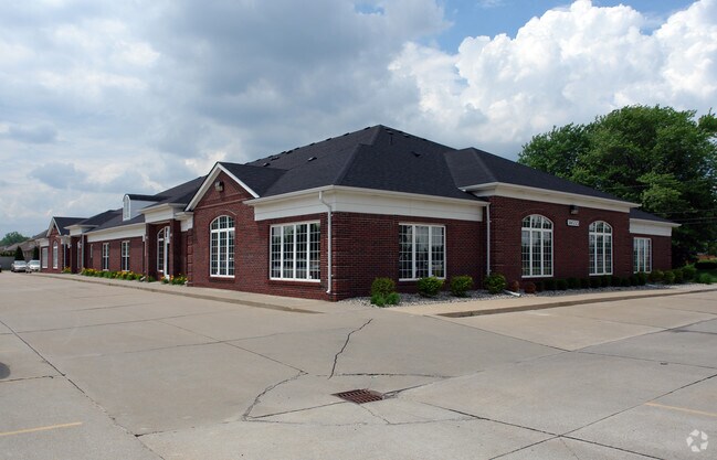
Property Record
38555 Mound Rd, Sterling Heights, MI 48310

Property Detail
38555 Mound Rd
10-10-20-276-030
NEW ERA VICTORY GARDEN FARMS LOT 8 EXC WLY 480.0 FT. SPLIT FROM -006 FOR 2000.
Officebuilding
Macomb
O-R
Michigan
B and X Area of moderate flood hazard, usually the area between the limits of the 100-year and 500-year floods.
8
2025
1.19 AC
2025
Macomb West
231400
Detroit
11,720 SF
Detroit-Warren-Dearborn, MI
NEARBY LISTINGS FOR SALE OR LEASE
DEMOGRAPHICS near 38555 Mound Rd
1 mile
3 mile
5 mile
2025 Total Population
8,229
103,813
265,834
2030 Population
8,185
104,862
268,862
Pop Growth 2025-2030
(0.53%)
+ 1.01%
+ 1.14%
Average Age
42
42
42
2025 Total Households
2,697
38,170
105,687
HH Growth 2025-2030
(0.48%)
+ 1.10%
+ 1.28%
Median Household Inc
$76,513
$79,976
$78,871
Avg Household Size
2.90
2.70
2.50
2025 Avg HH Vehicles
2.00
2.00
2.00
Median Home Value
$260,123
$271,495
$270,020
Median Year Built
1978
1975
1975
Nearby Places
Map Layers
Map Styles
 Street
 Aerial
Layers
 Traffic
 Biking
Places
Listings with unknown addresses are not visible on the map
- Restaurants
- Banks
- Shops
- Fitness
- Groceries
PUBLIC TRANSPORTATION
COMMUTER RAIL
Troy Amtrak Station (Wolverine - Amtrak)
Drive
Walk
Distance
Troy Amtrak Station (Wolverine - Amtrak)
17 min
9.6 mi
AIRPORT
Windsor International
Drive
Walk
Distance
Windsor International
51 min
30.6 mi
Detroit Metro Wayne County
Drive
Walk
Distance
Detroit Metro Wayne County
56 min
40.2 mi
Freight Ports
Port of Toledo
Drive
Walk
Distance
Port of Toledo
102 min
81.1 mi
SALE & LEASE HISTORY
LISTING DATE
SALE/LEASE

Nov 18, 2016
For Sale
Nov 14, 2018
For Lease
Dec 10, 2024
For Lease
Apr 04, 2017
For Lease
Apr 04, 2017
For Sale
Nearby Properties
Address
Land Use
TOTAL SIZE
Lot Size
Zoning
Address
Land Use
TOTAL SIZE
Lot Size
Zoning
920,611 SF
M-2
Address
Land Use
TOTAL SIZE
Lot Size
Zoning
1,024,233 SF
287.20 AC
M-2
Address
Land Use
TOTAL SIZE
Lot Size
Zoning
2,726,159 SF
199.39 AC
M-2
Address
Land Use
TOTAL SIZE
Lot Size
Zoning
40.32 AC
RM-2
Address
Land Use
TOTAL SIZE
Lot Size
Zoning
146.36 AC
MHP
Address
Land Use
TOTAL SIZE
Lot Size
Zoning
569,813 SF
62.54 AC
M-2
Address
Land Use
TOTAL SIZE
Lot Size
Zoning
2,727,131 SF
155.26 AC
M-2
Address
Land Use
TOTAL SIZE
Lot Size
Zoning
92.30 AC
MHP
Address
Land Use
TOTAL SIZE
Lot Size
Zoning
2,058,062 SF
141.65 AC
M-2
Address
Land Use
TOTAL SIZE
Lot Size
Zoning
226,380 SF
46.45 AC
M-1
Address
Land Use
TOTAL SIZE
Lot Size
Zoning
283,249 SF
M-2
Address
Land Use
TOTAL SIZE
Lot Size
Zoning
229,624 SF
13.55 AC
M-2
Address
Land Use
TOTAL SIZE
Lot Size
Zoning
645 SF
23.16 AC
RM-2
Address
Land Use
TOTAL SIZE
Lot Size
Zoning
2,984,492 SF
M-2
Address
Land Use
TOTAL SIZE
Lot Size
Zoning
423,027 SF
46.73 AC
M-1
Address
Land Use
TOTAL SIZE
Lot Size
Zoning
25.18 AC
RM-2
Address
Land Use
TOTAL SIZE
Lot Size
Zoning
203,282 SF
17.13 AC
C-2
Address
Land Use
TOTAL SIZE
Lot Size
Zoning
201,873 SF
M-1
Address
Land Use
TOTAL SIZE
Lot Size
Zoning
559,929 SF
41.57 AC
M-1
Address
Land Use
TOTAL SIZE
Lot Size
Zoning
135,274 SF
20.55 AC
RM-2
Address
Land Use
TOTAL SIZE
Lot Size
Zoning
139,846 SF
16 AC
RM-2
Address
Land Use
TOTAL SIZE
Lot Size
Zoning
210,000 SF
M-1
Address
Land Use
TOTAL SIZE
Lot Size
Zoning
159,750 SF
16.76 AC
M-1
Address
Land Use
TOTAL SIZE
Lot Size
Zoning
16.11 AC
RM-2
Address
Land Use
TOTAL SIZE
Lot Size
Zoning
219,437 SF
18.80 AC
PCD
Address
Land Use
TOTAL SIZE
Lot Size
Zoning
554,374 SF
22.15 AC
M-2
Address
Land Use
TOTAL SIZE
Lot Size
Zoning
200,000 SF
17.66 AC
M-2
Address
Land Use
TOTAL SIZE
Lot Size
Zoning
21.03 AC
RM-2
Address
Land Use
TOTAL SIZE
Lot Size
Zoning
126,450 SF
17.25 AC
RM-2
Address
Land Use
TOTAL SIZE
Lot Size
Zoning
210,080 SF
14.35 AC
RM-2
The World's #1 Commercial Real Estate Marketplace
Connect with us
© 2026 CoStar Group
The information above has been obtained from sources believed reliable. While we do not doubt its accuracy we have not verified it and make no guarantee, warranty or representation about it. It is your responsibility to independently confirm its accuracy and completeness. Any projections, opinions, assumptions, or estimates used are for example only and do not represent the current or future performance of the property. The value of this transaction to you depends on tax and other factors which should be evaluated by your tax, financial, and legal advisors. You and your advisors should conduct a careful, independent investigation of the property to determine to your satisfaction the suitability of the property for your needs.