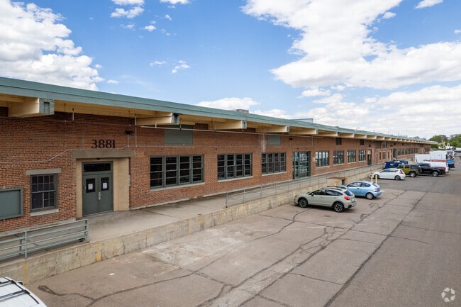
Property Record
3857 N Steele St, Denver, CO 80205
Current Lease Availabilities
NEARBY LISTINGS FOR SALE OR LEASE
Property Detail
3857 N Steele St
2243-00-097
PT T3S R68W SE/4 SEC 23 AND PT T3S R68W SE/W SEC 24 DAF COM NW COR CHEESMAN AND MOFFATS ADD B1 L1 TH N 576.18FT TPOBTH N 18.99FT E 499.34FT S 96.17FT W 0.5FT S 179.52FT W 113.66FT
Officebuilding
Denver
X
Colorado
08005C0025K
1
2024
1.70 AC
2024
Lower North Central
003602
Denver
20,451 SF
Denver-Aurora-Lakewood, CO
DEMOGRAPHICS near 3857 N Steele St
1 Mile
3 Mile
5 Mile
2024 Total Population
16,040
157,454
413,397
2029 Population
16,148
159,996
421,653
Pop Growth 2024-2029
+ 0.67%
+ 1.61%
+ 2.00%
Average Age
36
37
37
2024 Total Households
5,994
81,018
195,051
HH Growth 2024-2029
+ 0.47%
+ 1.69%
+ 1.95%
Median Household Inc
$73,678
$82,398
$88,567
Avg Household Size
2.50
1.80
2.00
2024 Avg HH Vehicles
2.00
1.00
1.00
Median Home Value
$502,420
$662,096
$670,339
Median Year Built
1949
1968
1971
Nearby Places
Map Layers
Map Styles
 Street
 Aerial
- Restaurants
- Banks
- Shops
- Fitness
- Groceries
PUBLIC TRANSPORTATION
COMMUTER RAIL
38Th & Blake Station Track 1 (Union Station to Denver Airport Station - Regional Transportation District)
DRIVE
WALK
Distance
38Th & Blake Station Track 1 (Union Station to Denver Airport Station - Regional Transportation District)
3 min
19 min
1.0 mi
38Th & Blake Station Track 2 (Union Station to Denver Airport Station - Regional Transportation District)
DRIVE
WALK
Distance
38Th & Blake Station Track 2 (Union Station to Denver Airport Station - Regional Transportation District)
8 min
20 min
1.1 mi
AIRPORT
Denver International
DRIVE
WALK
Distance
Denver International
29 min
21.3 mi
Freight Ports
Tulsa Port Of Catoosa
DRIVE
WALK
Distance
Tulsa Port Of Catoosa
726 min
706.8 mi
Nearby Properties
Address
Land Use
TOTAL SIZE
Lot Size
Zoning
Address
Land Use
TOTAL SIZE
Lot Size
Zoning
1,882,179 SF
21.15 AC
D-TD
Address
Land Use
TOTAL SIZE
Lot Size
Zoning
857,233 SF
10.26 AC
CMP-H
Address
Land Use
TOTAL SIZE
Lot Size
Zoning
794,383 SF
0.90 AC
D-TD
Address
Land Use
TOTAL SIZE
Lot Size
Zoning
1,542,612 SF
1.56 AC
D-C
Address
Land Use
TOTAL SIZE
Lot Size
Zoning
1,567,575 SF
1.40 AC
D-C
Address
Land Use
TOTAL SIZE
Lot Size
Zoning
1,312,939 SF
1.15 AC
D-C
Address
Land Use
TOTAL SIZE
Lot Size
Zoning
1,048,471 SF
2.44 AC
PUD
Address
Land Use
TOTAL SIZE
Lot Size
Zoning
545,292 SF
1.15 AC
D-C
Address
Land Use
TOTAL SIZE
Lot Size
Zoning
656,257 SF
3.05 AC
D-CV
Address
Land Use
TOTAL SIZE
Lot Size
Zoning
614,750 SF
0.23 AC
D-C
Address
Land Use
TOTAL SIZE
Lot Size
Zoning
611,828 SF
0.94 AC
PUD
Address
Land Use
TOTAL SIZE
Lot Size
Zoning
150,202 SF
13.24 AC
T-MU-30
Address
Land Use
TOTAL SIZE
Lot Size
Zoning
337,495 SF
0.57 AC
D-C
Address
Land Use
TOTAL SIZE
Lot Size
Zoning
858,528 SF
2.53 AC
D-C
Address
Land Use
TOTAL SIZE
Lot Size
Zoning
755,793 SF
2.44 AC
D-C
Address
Land Use
TOTAL SIZE
Lot Size
Zoning
677,832 SF
2.42 AC
D-C
Address
Land Use
TOTAL SIZE
Lot Size
Zoning
298,387 SF
0.88 AC
PUD
Address
Land Use
TOTAL SIZE
Lot Size
Zoning
724,981 SF
1.26 AC
D-C
Address
Land Use
TOTAL SIZE
Lot Size
Zoning
405,974 SF
1.78 AC
PUD
Address
Land Use
TOTAL SIZE
Lot Size
Zoning
1,018,386 SF
2.46 AC
D-C
Address
Land Use
TOTAL SIZE
Lot Size
Zoning
290,821 SF
1.16 AC
PUD
Address
Land Use
TOTAL SIZE
Lot Size
Zoning
604,358 SF
2.45 AC
D-C
Address
Land Use
TOTAL SIZE
Lot Size
Zoning
716,151 SF
2.45 AC
D-C
Address
Land Use
TOTAL SIZE
Lot Size
Zoning
618,768 SF
1.23 AC
D-C
Address
Land Use
TOTAL SIZE
Lot Size
Zoning
778,340 SF
0.61 AC
D-C
Address
Land Use
TOTAL SIZE
Lot Size
Zoning
334,746 SF
1.25 AC
D-LD
Address
Land Use
TOTAL SIZE
Lot Size
Zoning
764,724 SF
1 AC
D-C
Address
Land Use
TOTAL SIZE
Lot Size
Zoning
824,150 SF
1.95 AC
D-C
Address
Land Use
TOTAL SIZE
Lot Size
Zoning
888,385 SF
20.40 AC
I-A
Address
Land Use
TOTAL SIZE
Lot Size
Zoning
497,777 SF
3.70 AC
D-CV
The World's #1 Commercial Real Estate Marketplace
Connect with us
© 2025 CoStar Group
The information above has been obtained from sources believed reliable. While we do not doubt its accuracy we have not verified it and make no guarantee, warranty or representation about it. It is your responsibility to independently confirm its accuracy and completeness. Any projections, opinions, assumptions, or estimates used are for example only and do not represent the current or future performance of the property. The value of this transaction to you depends on tax and other factors which should be evaluated by your tax, financial, and legal advisors. You and your advisors should conduct a careful, independent investigation of the property to determine to your satisfaction the suitability of the property for your needs.