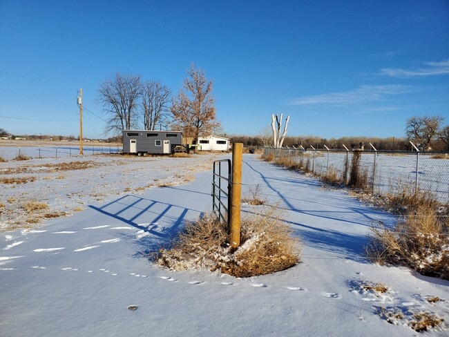
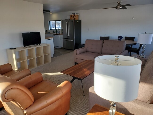
Property Record
386 29Th Ln, Pueblo, CO 81006

Property Detail
386 29Th Ln
0-4-36-0-00-074
BEG PT 3402.93 FT S OF + 8 FT E OF NW COR SEC TH CONT S,412.07 FT TH S 88 DEG 28 MIN (MEASURED) (S89 DEG 20 MIN,DEED) E 468 F (MEAS) TH N 00 DEG 30 MIN W 427.93 FT TH,SWLY TO PT OF BEG SW 1/4 36-20-64 4.59A
Farms
Pueblo
A-2
Colorado
AE The base floodplain where base flood elevations are provided. AE Zones are now used on new format FIRMs instead of A1-A30 Zones.
9.18 AC
2025
Colorado East Area
2025
Other Market Areas
003001
Pueblo, CO
5,280 SF
NEARBY LISTINGS FOR SALE OR LEASE
-
-
View all Pueblo listings for sale on LoopNet.com
DEMOGRAPHICS near 386 29Th Ln
1 mile
3 mile
5 mile
2025 Total Population
541
9,173
37,878
2030 Population
552
9,268
38,116
Pop Growth 2025-2030
+ 2.03%
+ 1.04%
+ 0.63%
Average Age
40
42
40
2025 Total Households
196
3,455
14,665
HH Growth 2025-2030
+ 2.04%
+ 0.96%
+ 0.57%
Median Household Inc
$68,999
$71,261
$54,630
Avg Household Size
2.80
2.60
2.50
2025 Avg HH Vehicles
2.00
2.00
2.00
Median Home Value
$356,666
$355,661
$279,895
Median Year Built
1976
1974
1968
Nearby Places
Map Layers
Map Styles
 Street
 Aerial
Layers
 Traffic
 Biking
Places
Listings with unknown addresses are not visible on the map
- Restaurants
- Banks
- Shops
- Fitness
- Groceries
SALE & LEASE HISTORY
LISTING DATE
SALE/LEASE

Feb 25, 2021
For Sale
Nearby Properties
Address
Land Use
TOTAL SIZE
Lot Size
Zoning
Address
Land Use
TOTAL SIZE
Lot Size
Zoning
225,504 SF
37.40 AC
I2:IND/MAN
Address
Land Use
TOTAL SIZE
Lot Size
Zoning
1,158,183 SF
84.46 AC
I2:IND/MAN
Address
Land Use
TOTAL SIZE
Lot Size
Zoning
196,492 SF
11.41 AC
I3:IND/HEA
Address
Land Use
TOTAL SIZE
Lot Size
Zoning
148,404 SF
35.67 AC
I1:IND/PAR
Address
Land Use
TOTAL SIZE
Lot Size
Zoning
84,386 SF
0.11 AC
I1:IND/PAR
Address
Land Use
TOTAL SIZE
Lot Size
Zoning
259,600 SF
44.62 AC
I1:IND/PAR
Address
Land Use
TOTAL SIZE
Lot Size
Zoning
26,550 SF
3.52 AC
S1:SPC/PUB
Address
Land Use
TOTAL SIZE
Lot Size
Zoning
191,905 SF
11.20 AC
I1:IND/PAR
Address
Land Use
TOTAL SIZE
Lot Size
Zoning
29,337 SF
6.02 AC
I2:IND/MAN
Address
Land Use
TOTAL SIZE
Lot Size
Zoning
128,100 SF
17.28 AC
I2:IND/MAN
Address
Land Use
TOTAL SIZE
Lot Size
Zoning
288,672 SF
27.56 AC
I2:IND/MAN
Address
Land Use
TOTAL SIZE
Lot Size
Zoning
140,480 SF
10.03 AC
I2:IND/MAN
Address
Land Use
TOTAL SIZE
Lot Size
Zoning
63,500 SF
3.80 AC
I2:IND/MAN
Address
Land Use
TOTAL SIZE
Lot Size
Zoning
68,999 SF
4.47 AC
I2:IND/MAN
Address
Land Use
TOTAL SIZE
Lot Size
Zoning
16,933 SF
25.26 AC
I3:IND/HEA
Address
Land Use
TOTAL SIZE
Lot Size
Zoning
155,800 SF
16.46 AC
I1:IND/PAR
Address
Land Use
TOTAL SIZE
Lot Size
Zoning
26,400 SF
4.87 AC
I2:IND/MAN
Address
Land Use
TOTAL SIZE
Lot Size
Zoning
29,160 SF
7.66 AC
I1:IND/PAR
Address
Land Use
TOTAL SIZE
Lot Size
Zoning
7,706 SF
1.80 AC
I2:IND/MAN
Address
Land Use
TOTAL SIZE
Lot Size
Zoning
6,384 SF
0.81 AC
R-3
Address
Land Use
TOTAL SIZE
Lot Size
Zoning
50,720 SF
6.15 AC
I2:IND/MAN
Address
Land Use
TOTAL SIZE
Lot Size
Zoning
5,482 SF
1.03 AC
R-A
Address
Land Use
TOTAL SIZE
Lot Size
Zoning
80,700 SF
9.89 AC
A2:AG/1&2
Address
Land Use
TOTAL SIZE
Lot Size
Zoning
31,328 SF
5.22 AC
I1:IND/PAR
Address
Land Use
TOTAL SIZE
Lot Size
Zoning
128,994 SF
8.77 AC
I2:IND/MAN
Address
Land Use
TOTAL SIZE
Lot Size
Zoning
50,720 SF
6.23 AC
I2:IND/MAN
Address
Land Use
TOTAL SIZE
Lot Size
Zoning
3,054 SF
1.25 AC
Address
Land Use
TOTAL SIZE
Lot Size
Zoning
135,019 SF
19.10 AC
I2:IND/MAN
Address
Land Use
TOTAL SIZE
Lot Size
Zoning
4,970 SF
1 AC
A-3
The World's #1 Commercial Real Estate Marketplace
Connect with us
© 2026 CoStar Group
The information above has been obtained from sources believed reliable. While we do not doubt its accuracy we have not verified it and make no guarantee, warranty or representation about it. It is your responsibility to independently confirm its accuracy and completeness. Any projections, opinions, assumptions, or estimates used are for example only and do not represent the current or future performance of the property. The value of this transaction to you depends on tax and other factors which should be evaluated by your tax, financial, and legal advisors. You and your advisors should conduct a careful, independent investigation of the property to determine to your satisfaction the suitability of the property for your needs.