Property Record
386 Laurelwood Rd, Pottstown, PA 19465
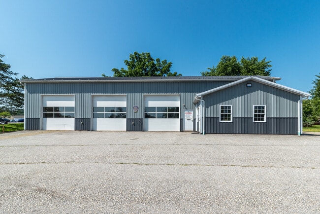
This Property Is For Sale
NEARBY LISTINGS FOR SALE OR LEASE
Property Detail
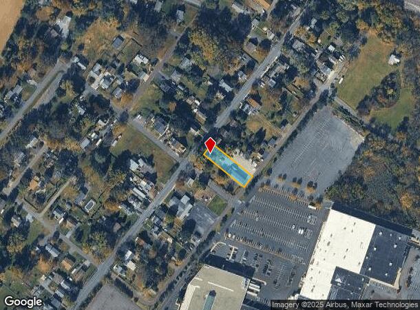
386 Laurelwood Rd
17-03C-0072.0000
Survey Made Ralph E Shaner & Son Enginee
Autorepair
LOT & DWG
X
Chester
42029C0015G
Pennsylvania
2024
0.30 AC
2025
Exton/Whitelands
301401
Philadelphia
5,250 SF
Philadelphia-Camden-Wilmington, PA-NJ-DE-MD
DEMOGRAPHICS near 386 Laurelwood Rd
1 Mile
3 Mile
5 Mile
2024 Total Population
5,818
43,877
79,551
2029 Population
6,130
45,962
83,337
Pop Growth 2024-2029
+ 5.36%
+ 4.75%
+ 4.76%
Average Age
39
41
41
2024 Total Households
2,494
17,716
30,916
HH Growth 2024-2029
+ 5.49%
+ 4.79%
+ 4.85%
Median Household Inc
$63,875
$69,548
$85,713
Avg Household Size
2.30
2.40
2.50
2024 Avg HH Vehicles
2.00
2.00
2.00
Median Home Value
$239,176
$242,394
$314,338
Median Year Built
1951
1956
1969
Nearby Places
Map Layers
Map Styles
 Street
 Aerial
- Restaurants
- Banks
- Shops
- Fitness
- Groceries
Nearby Properties
Address
Land Use
TOTAL SIZE
Lot Size
Zoning
Address
Land Use
TOTAL SIZE
Lot Size
Zoning
707,965 SF
80.33 AC
RMHD
Address
Land Use
TOTAL SIZE
Lot Size
Zoning
406,166 SF
65.54 AC
C
Address
Land Use
TOTAL SIZE
Lot Size
Zoning
327,827 SF
21 AC
RMD
Address
Land Use
TOTAL SIZE
Lot Size
Zoning
309,443 SF
20.56 AC
GE
Address
Land Use
TOTAL SIZE
Lot Size
Zoning
172,766 SF
43.12 AC
R3
Address
Land Use
TOTAL SIZE
Lot Size
Zoning
181,947 SF
8.19 AC
RMD
Address
Land Use
TOTAL SIZE
Lot Size
Zoning
191,272 SF
48.22 AC
R2
Address
Land Use
TOTAL SIZE
Lot Size
Zoning
240,140 SF
31.50 AC
R3
Address
Land Use
TOTAL SIZE
Lot Size
Zoning
135,368 SF
5.31 AC
DG
Address
Land Use
TOTAL SIZE
Lot Size
Zoning
150,711 SF
21.72 AC
HB
Address
Land Use
TOTAL SIZE
Lot Size
Zoning
216,693 SF
38 AC
I1
Address
Land Use
TOTAL SIZE
Lot Size
Zoning
176,741 SF
17.40 AC
HB
Address
Land Use
TOTAL SIZE
Lot Size
Zoning
589,859 SF
53.31 AC
C2
Address
Land Use
TOTAL SIZE
Lot Size
Zoning
138,563 SF
12.98 AC
C
Address
Land Use
TOTAL SIZE
Lot Size
Zoning
94,997 SF
6 AC
R3
Address
Land Use
TOTAL SIZE
Lot Size
Zoning
681,836 SF
40.12 AC
HI
Address
Land Use
TOTAL SIZE
Lot Size
Zoning
165,168 SF
11.10 AC
C2
Address
Land Use
TOTAL SIZE
Lot Size
Zoning
175,151 SF
14.74 AC
RMHD
Address
Land Use
TOTAL SIZE
Lot Size
Zoning
166,912 SF
11.10 AC
R4
Address
Land Use
TOTAL SIZE
Lot Size
Zoning
66,270 SF
1.20 AC
R1
Address
Land Use
TOTAL SIZE
Lot Size
Zoning
104,075 SF
14 AC
SC
Address
Land Use
TOTAL SIZE
Lot Size
Zoning
86,532 SF
13 AC
R3
Address
Land Use
TOTAL SIZE
Lot Size
Zoning
79,010 SF
13.75 AC
C2
Address
Land Use
TOTAL SIZE
Lot Size
Zoning
70,319 SF
7.31 AC
CO
Address
Land Use
TOTAL SIZE
Lot Size
Zoning
77,944 SF
0.47 AC
D
Address
Land Use
TOTAL SIZE
Lot Size
Zoning
61,031 SF
14.54 AC
R3
Address
Land Use
TOTAL SIZE
Lot Size
Zoning
45,138 SF
9.13 AC
C
Address
Land Use
TOTAL SIZE
Lot Size
Zoning
114,240 SF
18.57 AC
IN
Address
Land Use
TOTAL SIZE
Lot Size
Zoning
56,774 SF
1.58 AC
C
Address
Land Use
TOTAL SIZE
Lot Size
Zoning
227,008 SF
0.79 AC
TTN
The World's #1 Commercial Real Estate Marketplace
Connect with us
© 2025 CoStar Group
The information above has been obtained from sources believed reliable. While we do not doubt its accuracy we have not verified it and make no guarantee, warranty or representation about it. It is your responsibility to independently confirm its accuracy and completeness. Any projections, opinions, assumptions, or estimates used are for example only and do not represent the current or future performance of the property. The value of this transaction to you depends on tax and other factors which should be evaluated by your tax, financial, and legal advisors. You and your advisors should conduct a careful, independent investigation of the property to determine to your satisfaction the suitability of the property for your needs.