Property Record
3860 Panola Rd, Lithonia, GA 30038
NEARBY LISTINGS FOR SALE OR LEASE
Property Detail
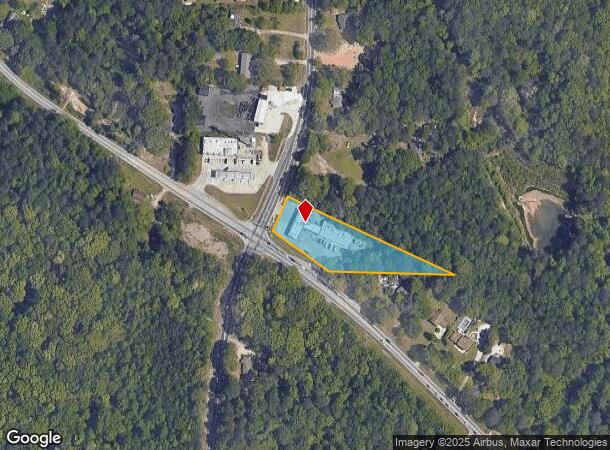
3860 Panola Rd
Atlanta-Sandy Springs-Roswell, GA
University Heights Sec 02
16-020-04-015
BEG X BROWNS MILL RD & PANOLA RD
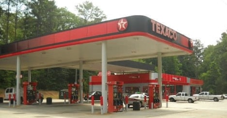
Supermarket
DeKalb
X
Georgia
13247C0070D
15
2025
1.22 AC
2025
Forest Park/Morrow
023432
Atlanta
5,000 SF
DEMOGRAPHICS near 3860 Panola Rd
1 Mile
3 Mile
5 Mile
2024 Total Population
4,865
48,246
140,178
2029 Population
4,836
47,947
139,995
Pop Growth 2024-2029
(0.60%)
(0.62%)
(0.13%)
Average Age
40
40
39
2024 Total Households
1,665
17,904
51,940
HH Growth 2024-2029
(0.60%)
(0.71%)
(0.24%)
Median Household Inc
$72,387
$65,728
$63,166
Avg Household Size
2.90
2.70
2.60
2024 Avg HH Vehicles
3.00
2.00
2.00
Median Home Value
$166,136
$216,497
$195,269
Median Year Built
1986
1992
1991
Nearby Places
Map Layers
Map Styles
 Street
 Aerial
- Restaurants
- Banks
- Shops
- Fitness
- Groceries
PUBLIC TRANSPORTATION
AIRPORT
Hartsfield - Jackson Atlanta International
DRIVE
WALK
Distance
Hartsfield - Jackson Atlanta International
30 min
17.8 mi
Freight Ports
Georgia Ports - Savannah
DRIVE
WALK
Distance
Georgia Ports - Savannah
273 min
238.5 mi
Nearby Properties
Address
Land Use
TOTAL SIZE
Lot Size
Zoning
Address
Land Use
TOTAL SIZE
Lot Size
Zoning
834,629 SF
59.49 AC
RM100
Address
Land Use
TOTAL SIZE
Lot Size
Zoning
317,008 SF
37.05 AC
RM100
Address
Land Use
TOTAL SIZE
Lot Size
Zoning
484,198 SF
31.10 AC
RM100
Address
Land Use
TOTAL SIZE
Lot Size
Zoning
250,496 SF
14.35 AC
OI
Address
Land Use
TOTAL SIZE
Lot Size
Zoning
249,506 SF
21 AC
RM100
Address
Land Use
TOTAL SIZE
Lot Size
Zoning
189,472 SF
30.90 AC
RM100
Address
Land Use
TOTAL SIZE
Lot Size
Zoning
217,925 SF
23.69 AC
RM100
Address
Land Use
TOTAL SIZE
Lot Size
Zoning
287,681 SF
20.10 AC
RM100
Address
Land Use
TOTAL SIZE
Lot Size
Zoning
86,140 SF
61.60 AC
R100
Address
Land Use
TOTAL SIZE
Lot Size
Zoning
208,711 SF
34.59 AC
X
Address
Land Use
TOTAL SIZE
Lot Size
Zoning
182,490 SF
12.46 AC
RM100
Address
Land Use
TOTAL SIZE
Lot Size
Zoning
168,610 SF
19 AC
M
Address
Land Use
TOTAL SIZE
Lot Size
Zoning
365,757 SF
31.36 AC
RM100
Address
Land Use
TOTAL SIZE
Lot Size
Zoning
155,447 SF
14.33 AC
X
Address
Land Use
TOTAL SIZE
Lot Size
Zoning
272,304 SF
25.70 AC
RM100
Address
Land Use
TOTAL SIZE
Lot Size
Zoning
66,800 SF
10.46 AC
C1
Address
Land Use
TOTAL SIZE
Lot Size
Zoning
138,777 SF
22.01 AC
X
Address
Land Use
TOTAL SIZE
Lot Size
Zoning
111,628 SF
14.76 AC
M
Address
Land Use
TOTAL SIZE
Lot Size
Zoning
198,695 SF
10.62 AC
X
Address
Land Use
TOTAL SIZE
Lot Size
Zoning
86,328 SF
4.07 AC
C1: LOCAL
Address
Land Use
TOTAL SIZE
Lot Size
Zoning
135,539 SF
15.86 AC
X
Address
Land Use
TOTAL SIZE
Lot Size
Zoning
83,599 SF
1.52 AC
X
Address
Land Use
TOTAL SIZE
Lot Size
Zoning
137,557 SF
11.04 AC
RM100
Address
Land Use
TOTAL SIZE
Lot Size
Zoning
38,919 SF
13.23 AC
C1
Address
Land Use
TOTAL SIZE
Lot Size
Zoning
35,128 SF
4.82 AC
M
Address
Land Use
TOTAL SIZE
Lot Size
Zoning
111,885 SF
8.49 AC
X
Address
Land Use
TOTAL SIZE
Lot Size
Zoning
45,218 SF
10 AC
C1
Address
Land Use
TOTAL SIZE
Lot Size
Zoning
88,380 SF
4.90 AC
RM100
Address
Land Use
TOTAL SIZE
Lot Size
Zoning
66,900 SF
6.29 AC
C1
Address
Land Use
TOTAL SIZE
Lot Size
Zoning
85,001 SF
7.37 AC
M
The World's #1 Commercial Real Estate Marketplace
Connect with us
© 2025 CoStar Group
The information above has been obtained from sources believed reliable. While we do not doubt its accuracy we have not verified it and make no guarantee, warranty or representation about it. It is your responsibility to independently confirm its accuracy and completeness. Any projections, opinions, assumptions, or estimates used are for example only and do not represent the current or future performance of the property. The value of this transaction to you depends on tax and other factors which should be evaluated by your tax, financial, and legal advisors. You and your advisors should conduct a careful, independent investigation of the property to determine to your satisfaction the suitability of the property for your needs.