Property Record
3860 S 24Th St, Council Bluffs, IA 51501

NEARBY LISTINGS FOR SALE OR LEASE
-
-
View all Council Bluffs listings for sale on LoopNet.com
Property Detail
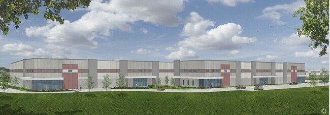
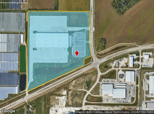
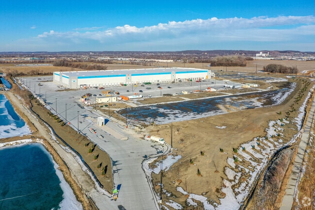
3860 S 24Th St
Omaha-Council Bluffs, NE-IA
South 24Th And Highway 275 Industrial
7444-10-400-006
SOUTH 24TH & HIGHWAY 275 INDUSTRIAL LT 1
Warehouse
Pottawattamie
X
Iowa
31153C0085G
1
2025
50.56 AC
2025
Council Bluffs
031400
Omaha/Council Bluffs
DEMOGRAPHICS near 3860 S 24Th St
1 Mile
3 Mile
5 Mile
2024 Total Population
3,800
31,907
157,919
2029 Population
3,796
31,926
160,500
Pop Growth 2024-2029
(0.11%)
+ 0.06%
+ 1.63%
Average Age
39
39
37
2024 Total Households
1,422
12,494
61,305
HH Growth 2024-2029
(0.07%)
+ 0.02%
+ 1.81%
Median Household Inc
$47,949
$51,702
$54,127
Avg Household Size
2.50
2.50
2.40
2024 Avg HH Vehicles
2.00
2.00
2.00
Median Home Value
$93,581
$138,388
$160,412
Median Year Built
1992
1959
1958
Nearby Places
Map Layers
Map Styles
 Street
 Aerial
- Restaurants
- Banks
- Shops
- Fitness
- Groceries
PUBLIC TRANSPORTATION
COMMUTER RAIL
Omaha Amtrak Station (California Zephyr - Amtrak)
DRIVE
WALK
Distance
Omaha Amtrak Station (California Zephyr - Amtrak)
11 min
6.0 mi
Omaha Amtrak Station (California Zephyr - Amtrak)
DRIVE
WALK
Distance
Omaha Amtrak Station (California Zephyr - Amtrak)
11 min
6.1 mi
AIRPORT
Eppley Airfield
DRIVE
WALK
Distance
Eppley Airfield
19 min
8.9 mi
Freight Ports
Tulsa Port Of Catoosa
DRIVE
WALK
Distance
Tulsa Port Of Catoosa
457 min
413.8 mi
Nearby Properties
Address
Land Use
TOTAL SIZE
Lot Size
Zoning
Address
Land Use
TOTAL SIZE
Lot Size
Zoning
62.66 AC
P-C
Address
Land Use
TOTAL SIZE
Lot Size
Zoning
36.26 AC
P-C
Address
Land Use
TOTAL SIZE
Lot Size
Zoning
30.39 AC
P-C
Address
Land Use
TOTAL SIZE
Lot Size
Zoning
52.44 AC
I-2
Address
Land Use
TOTAL SIZE
Lot Size
Zoning
16.18 AC
P-C
Address
Land Use
TOTAL SIZE
Lot Size
Zoning
27.38 AC
I-2
Address
Land Use
TOTAL SIZE
Lot Size
Zoning
42.97 AC
I-2
Address
Land Use
TOTAL SIZE
Lot Size
Zoning
68.36 AC
R-1M
Address
Land Use
TOTAL SIZE
Lot Size
Zoning
98,202 SF
17.88 AC
P-C
Address
Land Use
TOTAL SIZE
Lot Size
Zoning
0.89 AC
P-C
Address
Land Use
TOTAL SIZE
Lot Size
Zoning
37.25 AC
I-2
Address
Land Use
TOTAL SIZE
Lot Size
Zoning
15.96 AC
I-2
Address
Land Use
TOTAL SIZE
Lot Size
Zoning
20 AC
I-2
Address
Land Use
TOTAL SIZE
Lot Size
Zoning
3,552 SF
18.50 AC
I-2
Address
Land Use
TOTAL SIZE
Lot Size
Zoning
22.91 AC
A-P
Address
Land Use
TOTAL SIZE
Lot Size
Zoning
21.72 AC
I-2
Address
Land Use
TOTAL SIZE
Lot Size
Zoning
21.91 AC
P-C
Address
Land Use
TOTAL SIZE
Lot Size
Zoning
124,128 SF
15.62 AC
I-2
Address
Land Use
TOTAL SIZE
Lot Size
Zoning
32.10 AC
I-2
Address
Land Use
TOTAL SIZE
Lot Size
Zoning
14.24 AC
I-2
Address
Land Use
TOTAL SIZE
Lot Size
Zoning
23.52 AC
I-2
Address
Land Use
TOTAL SIZE
Lot Size
Zoning
34.64 AC
I-2
Address
Land Use
TOTAL SIZE
Lot Size
Zoning
2.32 AC
P-C
Address
Land Use
TOTAL SIZE
Lot Size
Zoning
67,671 SF
5.52 AC
C-2
Address
Land Use
TOTAL SIZE
Lot Size
Zoning
23.47 AC
A-P
Address
Land Use
TOTAL SIZE
Lot Size
Zoning
3.67 AC
P-C
Address
Land Use
TOTAL SIZE
Lot Size
Zoning
33.74 AC
R-1M
Address
Land Use
TOTAL SIZE
Lot Size
Zoning
9.97 AC
P-C
Address
Land Use
TOTAL SIZE
Lot Size
Zoning
270,446 SF
13.68 AC
R7
The World's #1 Commercial Real Estate Marketplace
Connect with us
© 2026 CoStar Group
The information above has been obtained from sources believed reliable. While we do not doubt its accuracy we have not verified it and make no guarantee, warranty or representation about it. It is your responsibility to independently confirm its accuracy and completeness. Any projections, opinions, assumptions, or estimates used are for example only and do not represent the current or future performance of the property. The value of this transaction to you depends on tax and other factors which should be evaluated by your tax, financial, and legal advisors. You and your advisors should conduct a careful, independent investigation of the property to determine to your satisfaction the suitability of the property for your needs.