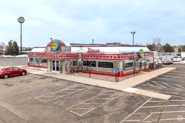
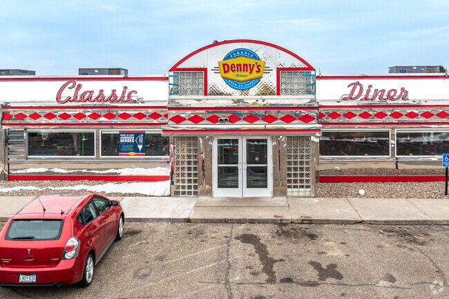
Property Record
38681 Tanger Dr, North Branch, MN 55056

NEARBY LISTINGS FOR SALE OR LEASE
Property Detail
38681 Tanger Dr
Minneapolis-St. Paul-Bloomington, MN-WI
Tanger Center
11-01029-01
SUBDIVISIONNAME TANGER CENTER LOT 002 BLOCK 001 SUBDIVISIONCD 11370
Commercialnec
Chisago
X
Minnesota
27025C0163D
2
2025
0.97 AC
2024
Chisago County
110302
Minneapolis/St Paul
3,520 SF
DEMOGRAPHICS near 38681 Tanger Dr
1 Mile
3 Mile
5 Mile
2024 Total Population
3,527
11,469
13,848
2029 Population
3,745
12,195
14,726
Pop Growth 2024-2029
+ 6.18%
+ 6.33%
+ 6.34%
Average Age
39
38
39
2024 Total Households
1,337
4,197
5,062
HH Growth 2024-2029
+ 6.21%
+ 6.41%
+ 6.42%
Median Household Inc
$58,157
$91,298
$94,642
Avg Household Size
2.60
2.70
2.70
2024 Avg HH Vehicles
2.00
2.00
2.00
Median Home Value
$254,835
$256,662
$261,000
Median Year Built
1993
1994
1993
Nearby Places
Map Layers
Map Styles
 Street
 Aerial
- Restaurants
- Banks
- Shops
- Fitness
- Groceries
SALE & LEASE HISTORY
LISTING DATE
SALE/LEASE

Sep 04, 2022
For Sale
Mar 30, 2018
For Sale
Mar 09, 2018
For Sale
Jul 19, 2018
For Sale
Jan 22, 2025
For Sale
Apr 23, 2018
For Sale
Nearby Properties
Address
Land Use
TOTAL SIZE
Lot Size
Zoning
Address
Land Use
TOTAL SIZE
Lot Size
Zoning
158,203 SF
74.66 AC
RR
Address
Land Use
TOTAL SIZE
Lot Size
Zoning
138,977 SF
58.21 AC
R1
Address
Land Use
TOTAL SIZE
Lot Size
Zoning
89,373 SF
60 AC
RR
Address
Land Use
TOTAL SIZE
Lot Size
Zoning
52,671 SF
8.94 AC
B3
Address
Land Use
TOTAL SIZE
Lot Size
Zoning
150,000 SF
27.15 AC
Address
Land Use
TOTAL SIZE
Lot Size
Zoning
61,103 SF
6.94 AC
Address
Land Use
TOTAL SIZE
Lot Size
Zoning
42,052 SF
3.89 AC
Address
Land Use
TOTAL SIZE
Lot Size
Zoning
41,062 SF
2.82 AC
Address
Land Use
TOTAL SIZE
Lot Size
Zoning
41,062 SF
2.36 AC
Address
Land Use
TOTAL SIZE
Lot Size
Zoning
41,062 SF
3.86 AC
Address
Land Use
TOTAL SIZE
Lot Size
Zoning
41,062 SF
2.52 AC
Address
Land Use
TOTAL SIZE
Lot Size
Zoning
53,041 SF
5.43 AC
B2
Address
Land Use
TOTAL SIZE
Lot Size
Zoning
58,368 SF
3.38 AC
R3
Address
Land Use
TOTAL SIZE
Lot Size
Zoning
80,358 SF
8.31 AC
B2
Address
Land Use
TOTAL SIZE
Lot Size
Zoning
58,024 SF
3.30 AC
R3
Address
Land Use
TOTAL SIZE
Lot Size
Zoning
45,756 SF
0.40 AC
CBD
Address
Land Use
TOTAL SIZE
Lot Size
Zoning
42,822 SF
3.04 AC
R3
Address
Land Use
TOTAL SIZE
Lot Size
Zoning
38,678 SF
2.78 AC
R3
Address
Land Use
TOTAL SIZE
Lot Size
Zoning
20,934 SF
1.92 AC
B3
Address
Land Use
TOTAL SIZE
Lot Size
Zoning
18,144 SF
2.50 AC
Address
Land Use
TOTAL SIZE
Lot Size
Zoning
135,510 SF
15.95 AC
B3
Address
Land Use
TOTAL SIZE
Lot Size
Zoning
1,820 SF
17.90 AC
R4
Address
Land Use
TOTAL SIZE
Lot Size
Zoning
19,006 SF
5.03 AC
RR
Address
Land Use
TOTAL SIZE
Lot Size
Zoning
57,840 SF
10.18 AC
I2
Address
Land Use
TOTAL SIZE
Lot Size
Zoning
28,670 SF
2.51 AC
R3
Address
Land Use
TOTAL SIZE
Lot Size
Zoning
12,000 SF
8.70 AC
RR
Address
Land Use
TOTAL SIZE
Lot Size
Zoning
8,246 SF
1.90 AC
B3
Address
Land Use
TOTAL SIZE
Lot Size
Zoning
41,260 SF
0.05 AC
I2
Address
Land Use
TOTAL SIZE
Lot Size
Zoning
14,030 SF
16.50 AC
I2
Address
Land Use
TOTAL SIZE
Lot Size
Zoning
49,800 SF
1.12 AC
I3
The World's #1 Commercial Real Estate Marketplace
Connect with us
© 2026 CoStar Group
The information above has been obtained from sources believed reliable. While we do not doubt its accuracy we have not verified it and make no guarantee, warranty or representation about it. It is your responsibility to independently confirm its accuracy and completeness. Any projections, opinions, assumptions, or estimates used are for example only and do not represent the current or future performance of the property. The value of this transaction to you depends on tax and other factors which should be evaluated by your tax, financial, and legal advisors. You and your advisors should conduct a careful, independent investigation of the property to determine to your satisfaction the suitability of the property for your needs.