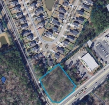
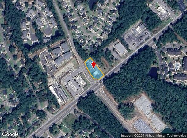
Property Record
3878 Ladson Rd, Ladson, SC 29456

NEARBY LISTINGS FOR SALE OR LEASE
Property Detail
3878 Ladson Rd
Charleston-North Charleston, SC
Plat Of The Subdivision Of Tract A Conta
154-00-00-012
LOT A-1A
Autorepair
Dorchester
X
South Carolina
45019C0260K
a-1a
2025
0.54 AC
2025
Dorchester County
003107
Charleston/N Charleston
235 SF
DEMOGRAPHICS near 3878 Ladson Rd
1 Mile
3 Mile
5 Mile
2024 Total Population
11,116
62,529
156,574
2029 Population
11,906
67,397
171,737
Pop Growth 2024-2029
+ 7.11%
+ 7.79%
+ 9.68%
Average Age
36
37
38
2024 Total Households
4,287
23,965
59,779
HH Growth 2024-2029
+ 6.97%
+ 7.64%
+ 9.50%
Median Household Inc
$71,022
$69,543
$70,169
Avg Household Size
2.60
2.60
2.50
2024 Avg HH Vehicles
2.00
2.00
2.00
Median Home Value
$210,788
$250,341
$250,533
Median Year Built
2002
2001
1997
Nearby Places
- Restaurants
- Banks
- Shops
- Fitness
- Groceries
PUBLIC TRANSPORTATION
AIRPORT
Charleston AFB/International
DRIVE
WALK
Distance
Charleston AFB/International
15 min
10.6 mi
Freight Ports
North Charleston Terminal
DRIVE
WALK
Distance
North Charleston Terminal
20 min
12.8 mi
SALE & LEASE HISTORY
LISTING DATE
SALE/LEASE

Aug 01, 2019
For Sale
Nearby Properties
Address
Land Use
TOTAL SIZE
Lot Size
Zoning
Address
Land Use
TOTAL SIZE
Lot Size
Zoning
Address
Land Use
TOTAL SIZE
Lot Size
Zoning
48.89 AC
Address
Land Use
TOTAL SIZE
Lot Size
Zoning
1,430 SF
28.27 AC
Address
Land Use
TOTAL SIZE
Lot Size
Zoning
182,112 SF
38.64 AC
Address
Land Use
TOTAL SIZE
Lot Size
Zoning
152,460 SF
26.94 AC
Address
Land Use
TOTAL SIZE
Lot Size
Zoning
28,770 SF
15.53 AC
Address
Land Use
TOTAL SIZE
Lot Size
Zoning
14.75 AC
Address
Land Use
TOTAL SIZE
Lot Size
Zoning
16.40 AC
Address
Land Use
TOTAL SIZE
Lot Size
Zoning
1,272 SF
18.46 AC
Address
Land Use
TOTAL SIZE
Lot Size
Zoning
Address
Land Use
TOTAL SIZE
Lot Size
Zoning
33.62 AC
Address
Land Use
TOTAL SIZE
Lot Size
Zoning
14.33 AC
Address
Land Use
TOTAL SIZE
Lot Size
Zoning
181,427 SF
16.47 AC
Address
Land Use
TOTAL SIZE
Lot Size
Zoning
194,515 SF
26.73 AC
Address
Land Use
TOTAL SIZE
Lot Size
Zoning
30,790 SF
7.59 AC
BERKELEY C
Address
Land Use
TOTAL SIZE
Lot Size
Zoning
Address
Land Use
TOTAL SIZE
Lot Size
Zoning
124,678 SF
65.93 AC
Address
Land Use
TOTAL SIZE
Lot Size
Zoning
13,620 SF
9.44 AC
BERKELEY C
Address
Land Use
TOTAL SIZE
Lot Size
Zoning
33,884 SF
10.49 AC
NORTH CHAR
Address
Land Use
TOTAL SIZE
Lot Size
Zoning
67,082 SF
12.07 AC
Address
Land Use
TOTAL SIZE
Lot Size
Zoning
112.78 AC
Address
Land Use
TOTAL SIZE
Lot Size
Zoning
20,070 SF
8.03 AC
BERKELEY C
Address
Land Use
TOTAL SIZE
Lot Size
Zoning
Address
Land Use
TOTAL SIZE
Lot Size
Zoning
43,740 SF
18.06 AC
BERKELEY C
Address
Land Use
TOTAL SIZE
Lot Size
Zoning
3.71 AC
Address
Land Use
TOTAL SIZE
Lot Size
Zoning
94,384 SF
27.24 AC
BERKELEY C
Address
Land Use
TOTAL SIZE
Lot Size
Zoning
22.80 AC
Address
Land Use
TOTAL SIZE
Lot Size
Zoning
1,332 SF
21.31 AC
Address
Land Use
TOTAL SIZE
Lot Size
Zoning
276,696 SF
17.87 AC
G-B_SV
Address
Land Use
TOTAL SIZE
Lot Size
Zoning
1,350 SF
25.78 AC
The World's #1 Commercial Real Estate Marketplace
Connect with us
© 2025 CoStar Group
The information above has been obtained from sources believed reliable. While we do not doubt its accuracy we have not verified it and make no guarantee, warranty or representation about it. It is your responsibility to independently confirm its accuracy and completeness. Any projections, opinions, assumptions, or estimates used are for example only and do not represent the current or future performance of the property. The value of this transaction to you depends on tax and other factors which should be evaluated by your tax, financial, and legal advisors. You and your advisors should conduct a careful, independent investigation of the property to determine to your satisfaction the suitability of the property for your needs.