Property Record
388 Boston Post Rd E, Marlborough, MA 01752

Property Detail
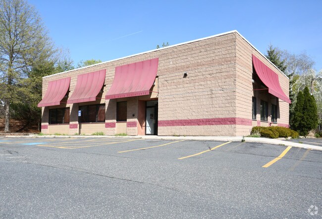
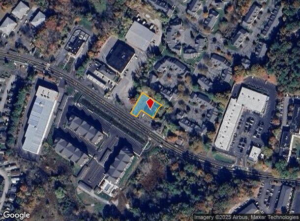
388 Boston Post Rd E
Restaurantbuilding
MIDDLESEX
B
Massachusetts
B and X Area of moderate flood hazard, usually the area between the limits of the 100-year and 500-year floods.
0.32 AC
2025
Marlborough
2025
Boston
321301
Boston-Cambridge-Newton, MA-NH
3,256 SF
MARL-000073-000054A
NEARBY LISTINGS FOR SALE OR LEASE
DEMOGRAPHICS near 388 Boston Post Rd E
1 mile
3 mile
5 mile
2025 Total Population
10,604
44,769
105,711
2030 Population
11,130
46,309
109,861
Pop Growth 2025-2030
+ 4.96%
+ 3.44%
+ 3.93%
Average Age
41
41
42
2025 Total Households
4,496
17,605
41,296
HH Growth 2025-2030
+ 4.94%
+ 3.57%
+ 4.11%
Median Household Inc
$74,222
$100,247
$118,644
Avg Household Size
2.30
2.50
2.50
2025 Avg HH Vehicles
2.00
2.00
2.00
Median Home Value
$435,591
$574,535
$659,882
Median Year Built
1981
1972
1973
Nearby Places
Map Layers
Map Styles
 Street
 Aerial
Transit
 Traffic
 Biking
Places
Listings with unknown addresses are not visible on the map
- Restaurants
- Banks
- Shops
- Fitness
- Groceries
PUBLIC TRANSPORTATION
COMMUTER RAIL
Southborough (Framingham/Worcester Line - Massachusetts Bay Transportation Authority Commuter Rail (Purple Line))
Drive
Walk
Distance
Southborough (Framingham/Worcester Line - Massachusetts Bay Transportation Authority Commuter Rail (Purple Line))
16 min
6.6 mi
Ashland (Framingham/Worcester Line - Massachusetts Bay Transportation Authority Commuter Rail (Purple Line))
Drive
Walk
Distance
Ashland (Framingham/Worcester Line - Massachusetts Bay Transportation Authority Commuter Rail (Purple Line))
18 min
8.3 mi
AIRPORT
Worcester Regional
Drive
Walk
Distance
Worcester Regional
36 min
24.3 mi
General Edward Lawrence Logan International
Drive
Walk
Distance
General Edward Lawrence Logan International
51 min
30.4 mi
SALE & LEASE HISTORY
LISTING DATE
SALE/LEASE

Jun 22, 2021
For Sale
Jul 14, 2025
For Lease
Dec 22, 2016
For Sale
Nearby Properties
Address
Land Use
TOTAL SIZE
Lot Size
Zoning
Address
Land Use
TOTAL SIZE
Lot Size
Zoning
21.41 AC
LI
Address
Land Use
TOTAL SIZE
Lot Size
Zoning
284,231 SF
62.04 AC
A2
Address
Land Use
TOTAL SIZE
Lot Size
Zoning
23,890 SF
36.39 AC
A3
Address
Land Use
TOTAL SIZE
Lot Size
Zoning
54.67 AC
LI
Address
Land Use
TOTAL SIZE
Lot Size
Zoning
4,188 SF
23.20 AC
B
Address
Land Use
TOTAL SIZE
Lot Size
Zoning
267,805 SF
30.74 AC
A2
Address
Land Use
TOTAL SIZE
Lot Size
Zoning
14.80 AC
M6
Address
Land Use
TOTAL SIZE
Lot Size
Zoning
7,960 SF
17.89 AC
RR
Address
Land Use
TOTAL SIZE
Lot Size
Zoning
157.48 AC
LI
Address
Land Use
TOTAL SIZE
Lot Size
Zoning
188,882 SF
19.37 AC
A3
Address
Land Use
TOTAL SIZE
Lot Size
Zoning
22.74 AC
A1
Address
Land Use
TOTAL SIZE
Lot Size
Zoning
35,211 SF
89 AC
RA
Address
Land Use
TOTAL SIZE
Lot Size
Zoning
1,976 SF
81.69 AC
RA
Address
Land Use
TOTAL SIZE
Lot Size
Zoning
9.66 AC
A1
Address
Land Use
TOTAL SIZE
Lot Size
Zoning
99,619 SF
1.56 AC
B
Address
Land Use
TOTAL SIZE
Lot Size
Zoning
21.17 AC
A1
Address
Land Use
TOTAL SIZE
Lot Size
Zoning
85,958 SF
13.52 AC
A3
Address
Land Use
TOTAL SIZE
Lot Size
Zoning
10,338 SF
4.76 AC
CA
Address
Land Use
TOTAL SIZE
Lot Size
Zoning
215,936 SF
15.63 AC
I
Address
Land Use
TOTAL SIZE
Lot Size
Zoning
196,145 SF
10.18 AC
LI
Address
Land Use
TOTAL SIZE
Lot Size
Zoning
128,838 SF
4.27 AC
RC
Address
Land Use
TOTAL SIZE
Lot Size
Zoning
4.65 AC
I
Address
Land Use
TOTAL SIZE
Lot Size
Zoning
71.89 AC
RR
Address
Land Use
TOTAL SIZE
Lot Size
Zoning
3.58 AC
B
Address
Land Use
TOTAL SIZE
Lot Size
Zoning
60,703 SF
4 AC
I
Address
Land Use
TOTAL SIZE
Lot Size
Zoning
116,597 SF
11.29 AC
B
Address
Land Use
TOTAL SIZE
Lot Size
Zoning
33,328 SF
0.95 AC
RC
Address
Land Use
TOTAL SIZE
Lot Size
Zoning
127,400 SF
14.55 AC
I
Address
Land Use
TOTAL SIZE
Lot Size
Zoning
102,380 SF
12.22 AC
LI
Address
Land Use
TOTAL SIZE
Lot Size
Zoning
112,548 SF
1 AC
The World's #1 Commercial Real Estate Marketplace
Connect with us
© 2026 CoStar Group
The information above has been obtained from sources believed reliable. While we do not doubt its accuracy we have not verified it and make no guarantee, warranty or representation about it. It is your responsibility to independently confirm its accuracy and completeness. Any projections, opinions, assumptions, or estimates used are for example only and do not represent the current or future performance of the property. The value of this transaction to you depends on tax and other factors which should be evaluated by your tax, financial, and legal advisors. You and your advisors should conduct a careful, independent investigation of the property to determine to your satisfaction the suitability of the property for your needs.