Property Record
388 Redding Rd, Lexington, KY 40517
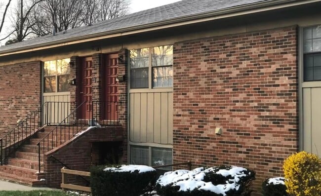

Property Detail
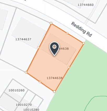
388 Redding Rd
13744638
A-508 LANSDOWNE LOT 5; BOOK: 1219 PAGE: 489
Apartment
Fayette
R-3
Kentucky
B and X Area of moderate flood hazard, usually the area between the limits of the 100-year and 500-year floods.
5
2025
0.27 AC
2025
Southeast Lexington
003504
Lexington/Fayette
7,300 SF
Lexington-Fayette, KY
NEARBY LISTINGS FOR SALE OR LEASE
DEMOGRAPHICS near 388 Redding Rd
1 mile
3 mile
5 mile
2025 Total Population
19,669
122,128
240,933
2030 Population
20,375
125,540
248,861
Pop Growth 2025-2030
+ 3.59%
+ 2.79%
+ 3.29%
Average Age
37
38
38
2025 Total Households
9,382
52,696
104,021
HH Growth 2025-2030
+ 3.79%
+ 3.07%
+ 3.59%
Median Household Inc
$49,953
$67,766
$63,383
Avg Household Size
2.00
2.20
2.20
2025 Avg HH Vehicles
2.00
2.00
2.00
Median Home Value
$251,252
$301,671
$315,839
Median Year Built
1977
1979
1981
Nearby Places
Map Layers
Map Styles
 Street
 Aerial
Layers
 Traffic
 Biking
Places
Listings with unknown addresses are not visible on the map
- Restaurants
- Banks
- Shops
- Fitness
- Groceries
PUBLIC TRANSPORTATION
AIRPORT
Blue Grass
Drive
Walk
Distance
Blue Grass
20 min
11.1 mi
Nearby Properties
Address
Land Use
TOTAL SIZE
Lot Size
Zoning
Address
Land Use
TOTAL SIZE
Lot Size
Zoning
635,961 SF
23.52 AC
P-1
Address
Land Use
TOTAL SIZE
Lot Size
Zoning
372,139 SF
4.82 AC
R-4
Address
Land Use
TOTAL SIZE
Lot Size
Zoning
582.34 AC
A-U
Address
Land Use
TOTAL SIZE
Lot Size
Zoning
76,441 SF
63.86 AC
A-U
Address
Land Use
TOTAL SIZE
Lot Size
Zoning
319,500 SF
0.25 AC
P-1
Address
Land Use
TOTAL SIZE
Lot Size
Zoning
318,370 SF
17.79 AC
B-6P
Address
Land Use
TOTAL SIZE
Lot Size
Zoning
301,644 SF
38.07 AC
R-1C
Address
Land Use
TOTAL SIZE
Lot Size
Zoning
292,730 SF
3.18 AC
R-1C
Address
Land Use
TOTAL SIZE
Lot Size
Zoning
4,299 SF
18.43 AC
R-4
Address
Land Use
TOTAL SIZE
Lot Size
Zoning
8,001 SF
32.59 AC
MU-3
Address
Land Use
TOTAL SIZE
Lot Size
Zoning
144,866 SF
14.83 AC
B-6P
Address
Land Use
TOTAL SIZE
Lot Size
Zoning
238,393 SF
9.83 AC
B-6P
Address
Land Use
TOTAL SIZE
Lot Size
Zoning
156,270 SF
11.18 AC
R-1C
Address
Land Use
TOTAL SIZE
Lot Size
Zoning
5,650 SF
22.46 AC
R-3
Address
Land Use
TOTAL SIZE
Lot Size
Zoning
22.10 AC
R-3
Address
Land Use
TOTAL SIZE
Lot Size
Zoning
12,767 SF
14.39 AC
R-3
Address
Land Use
TOTAL SIZE
Lot Size
Zoning
41,040 SF
14.77 AC
R-4
Address
Land Use
TOTAL SIZE
Lot Size
Zoning
184,756 SF
4.43 AC
MU-3
Address
Land Use
TOTAL SIZE
Lot Size
Zoning
91,484 SF
14.72 AC
B-6P
Address
Land Use
TOTAL SIZE
Lot Size
Zoning
7,402 SF
18.83 AC
R-4
Address
Land Use
TOTAL SIZE
Lot Size
Zoning
137,905 SF
23.79 AC
B-6P
Address
Land Use
TOTAL SIZE
Lot Size
Zoning
59,586 SF
5.37 AC
R-4
Address
Land Use
TOTAL SIZE
Lot Size
Zoning
4,859 SF
20.45 AC
R-3
Address
Land Use
TOTAL SIZE
Lot Size
Zoning
6.25 AC
A-U
Address
Land Use
TOTAL SIZE
Lot Size
Zoning
123,221 SF
17.32 AC
R-1B
Address
Land Use
TOTAL SIZE
Lot Size
Zoning
28,776 SF
13.83 AC
B-1
Address
Land Use
TOTAL SIZE
Lot Size
Zoning
73,590 SF
13.31 AC
R-1T
Address
Land Use
TOTAL SIZE
Lot Size
Zoning
25,880 SF
0.78 AC
P-1
Address
Land Use
TOTAL SIZE
Lot Size
Zoning
222,168 SF
26.49 AC
B-6P
Address
Land Use
TOTAL SIZE
Lot Size
Zoning
160,800 SF
74.22 AC
R-1C
The World's #1 Commercial Real Estate Marketplace
Connect with us
© 2026 CoStar Group
The information above has been obtained from sources believed reliable. While we do not doubt its accuracy we have not verified it and make no guarantee, warranty or representation about it. It is your responsibility to independently confirm its accuracy and completeness. Any projections, opinions, assumptions, or estimates used are for example only and do not represent the current or future performance of the property. The value of this transaction to you depends on tax and other factors which should be evaluated by your tax, financial, and legal advisors. You and your advisors should conduct a careful, independent investigation of the property to determine to your satisfaction the suitability of the property for your needs.