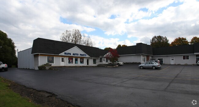
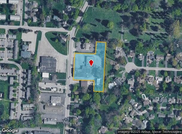
Property Record
380 S Union St, Spencerport, NY 14559
NEARBY LISTINGS FOR SALE OR LEASE
-
-
View all Spencerport listings for sale on LoopNet.com
Property Detail
380 S Union St
263801-087-170-0001-072-200
L57 T3 R1
Storesoffices
Monroe
X
New York
36055C0166G
72.200
2025
2.15 AC
2024
Northwest
014901
Rochester
17,953 SF
Rochester, NY
DEMOGRAPHICS near 380 S Union St
1 Mile
3 Mile
5 Mile
2024 Total Population
4,603
15,135
53,768
2029 Population
4,507
14,867
53,051
Pop Growth 2024-2029
(2.09%)
(1.77%)
(1.33%)
Average Age
42
43
43
2024 Total Households
1,881
6,093
21,887
HH Growth 2024-2029
(2.23%)
(1.87%)
(1.43%)
Median Household Inc
$71,089
$80,754
$76,556
Avg Household Size
2.40
2.50
2.40
2024 Avg HH Vehicles
2.00
2.00
2.00
Median Home Value
$177,958
$193,025
$179,185
Median Year Built
1970
1975
1978
Nearby Places
Map Layers
Map Styles
 Street
 Aerial
- Restaurants
- Banks
- Shops
- Fitness
- Groceries
PUBLIC TRANSPORTATION
AIRPORT
Frederick Douglass/Greater Rochester International
DRIVE
WALK
Distance
Frederick Douglass/Greater Rochester International
16 min
11.5 mi
Freight Ports
Albany, NY Port
DRIVE
WALK
Distance
Albany, NY Port
281 min
237.8 mi
SALE & LEASE HISTORY
LISTING DATE
SALE/LEASE

Jan 31, 2024
For Sale
Nearby Properties
Address
Land Use
TOTAL SIZE
Lot Size
Zoning
Address
Land Use
TOTAL SIZE
Lot Size
Zoning
280,300 SF
71.39 AC
LI
Address
Land Use
TOTAL SIZE
Lot Size
Zoning
279,852 SF
78.40 AC
R-1
Address
Land Use
TOTAL SIZE
Lot Size
Zoning
149,427 SF
10.90 AC
R-1
Address
Land Use
TOTAL SIZE
Lot Size
Zoning
180,566 SF
13.30 AC
R-1
Address
Land Use
TOTAL SIZE
Lot Size
Zoning
47,109 SF
15.10 AC
R-1
Address
Land Use
TOTAL SIZE
Lot Size
Zoning
87,106 SF
8.66 AC
SC
Address
Land Use
TOTAL SIZE
Lot Size
Zoning
60,509 SF
29.40 AC
R-1
Address
Land Use
TOTAL SIZE
Lot Size
Zoning
9,556 SF
21.24 AC
MFR
Address
Land Use
TOTAL SIZE
Lot Size
Zoning
186,687 SF
13.90 AC
LI
Address
Land Use
TOTAL SIZE
Lot Size
Zoning
8,386 SF
15.50 AC
MFR
Address
Land Use
TOTAL SIZE
Lot Size
Zoning
86,432 SF
34.86 AC
R-1
Address
Land Use
TOTAL SIZE
Lot Size
Zoning
3.20 AC
R-1
Address
Land Use
TOTAL SIZE
Lot Size
Zoning
42,944 SF
8.04 AC
05 - COMME
Address
Land Use
TOTAL SIZE
Lot Size
Zoning
13,764 SF
10.90 AC
MFR
Address
Land Use
TOTAL SIZE
Lot Size
Zoning
71,344 SF
29.90 AC
R-1
Address
Land Use
TOTAL SIZE
Lot Size
Zoning
19,280 SF
1.15 AC
B2
Address
Land Use
TOTAL SIZE
Lot Size
Zoning
14,671 SF
33.82 AC
GC
Address
Land Use
TOTAL SIZE
Lot Size
Zoning
65,627 SF
11.78 AC
LI
Address
Land Use
TOTAL SIZE
Lot Size
Zoning
76,314 SF
5.22 AC
LI
Address
Land Use
TOTAL SIZE
Lot Size
Zoning
64,308 SF
22.10 AC
R-1
Address
Land Use
TOTAL SIZE
Lot Size
Zoning
5,260 SF
5.63 AC
SC
Address
Land Use
TOTAL SIZE
Lot Size
Zoning
5,100 SF
21.27 AC
SSSO
Address
Land Use
TOTAL SIZE
Lot Size
Zoning
20,845 SF
2.87 AC
RB
Address
Land Use
TOTAL SIZE
Lot Size
Zoning
13,718 SF
4.85 AC
MFR
Address
Land Use
TOTAL SIZE
Lot Size
Zoning
3,904 SF
5.19 AC
R3
Address
Land Use
TOTAL SIZE
Lot Size
Zoning
35,044 SF
10.90 AC
R-1
Address
Land Use
TOTAL SIZE
Lot Size
Zoning
37,000 SF
15.80 AC
R2
Address
Land Use
TOTAL SIZE
Lot Size
Zoning
2,226 SF
5.61 AC
SC
Address
Land Use
TOTAL SIZE
Lot Size
Zoning
24,482 SF
97.01 AC
Address
Land Use
TOTAL SIZE
Lot Size
Zoning
14,834 SF
6.23 AC
02 - SINGL
The World's #1 Commercial Real Estate Marketplace
Connect with us
© 2025 CoStar Group
The information above has been obtained from sources believed reliable. While we do not doubt its accuracy we have not verified it and make no guarantee, warranty or representation about it. It is your responsibility to independently confirm its accuracy and completeness. Any projections, opinions, assumptions, or estimates used are for example only and do not represent the current or future performance of the property. The value of this transaction to you depends on tax and other factors which should be evaluated by your tax, financial, and legal advisors. You and your advisors should conduct a careful, independent investigation of the property to determine to your satisfaction the suitability of the property for your needs.