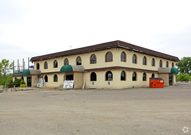
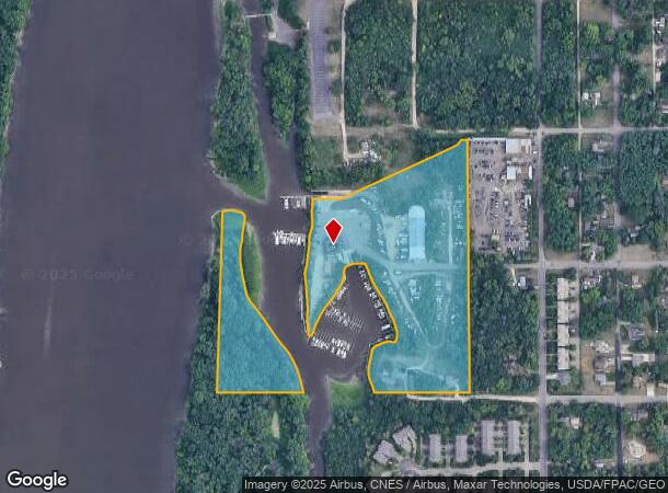
Property Record
388 9Th Ave, Saint Paul Park, MN 55071
NEARBY LISTINGS FOR SALE OR LEASE
Property Detail
388 9Th Ave
Minneapolis-St. Paul-Bloomington, MN-WI
Div No.2 St Paul Park
11-027-22-14-0007
ALL BLK 71 TOG/W S1/2 ADJ VAC UNNAMED R/W LYING S OF BLK 70 & N OF SD BLK 71 TOG/W W1/2 VA C LT A LYING S OF 8TH AVE & N OF 1
Apartment
Washington
AE
Minnesota
27037C0109E
a
2025
39.82 AC
2024
Woodbury
071300
Minneapolis/St Paul
11,876 SF
DEMOGRAPHICS near 388 9Th Ave
1 Mile
3 Mile
5 Mile
2024 Total Population
5,271
51,359
125,239
2029 Population
5,550
54,053
132,410
Pop Growth 2024-2029
+ 5.29%
+ 5.25%
+ 5.73%
Average Age
39
40
39
2024 Total Households
1,956
19,745
47,394
HH Growth 2024-2029
+ 5.47%
+ 5.02%
+ 5.54%
Median Household Inc
$74,860
$85,931
$91,033
Avg Household Size
2.70
2.50
2.60
2024 Avg HH Vehicles
2.00
2.00
2.00
Median Home Value
$254,015
$291,449
$310,086
Median Year Built
1978
1984
1985
Nearby Places
Map Layers
Map Styles
 Street
 Aerial
- Restaurants
- Banks
- Shops
- Fitness
- Groceries
PUBLIC TRANSPORTATION
AIRPORT
Minneapolis-St Paul International/Wold-Chamberlain
DRIVE
WALK
Distance
Minneapolis-St Paul International/Wold-Chamberlain
27 min
16.6 mi
Freight Ports
Port Milwaukee
DRIVE
WALK
Distance
Port Milwaukee
366 min
331.0 mi
Nearby Properties
Address
Land Use
TOTAL SIZE
Lot Size
Zoning
Address
Land Use
TOTAL SIZE
Lot Size
Zoning
238,188 SF
4.86 AC
Address
Land Use
TOTAL SIZE
Lot Size
Zoning
196,078 SF
31.29 AC
Address
Land Use
TOTAL SIZE
Lot Size
Zoning
605,774 SF
44.50 AC
Address
Land Use
TOTAL SIZE
Lot Size
Zoning
794,084 SF
6.97 AC
Address
Land Use
TOTAL SIZE
Lot Size
Zoning
123,968 SF
3.19 AC
Address
Land Use
TOTAL SIZE
Lot Size
Zoning
71,164 SF
10.79 AC
Address
Land Use
TOTAL SIZE
Lot Size
Zoning
212,331 SF
9.27 AC
Address
Land Use
TOTAL SIZE
Lot Size
Zoning
163,985 SF
7.06 AC
Address
Land Use
TOTAL SIZE
Lot Size
Zoning
169,237 SF
23.38 AC
Address
Land Use
TOTAL SIZE
Lot Size
Zoning
186,856 SF
Address
Land Use
TOTAL SIZE
Lot Size
Zoning
218,012 SF
9.22 AC
Address
Land Use
TOTAL SIZE
Lot Size
Zoning
192,004 SF
7.75 AC
Address
Land Use
TOTAL SIZE
Lot Size
Zoning
138,609 SF
3.76 AC
Address
Land Use
TOTAL SIZE
Lot Size
Zoning
41,040 SF
11.38 AC
Address
Land Use
TOTAL SIZE
Lot Size
Zoning
94,822 SF
34.92 AC
Address
Land Use
TOTAL SIZE
Lot Size
Zoning
150,469 SF
10.73 AC
Address
Land Use
TOTAL SIZE
Lot Size
Zoning
152,098 SF
8.23 AC
Address
Land Use
TOTAL SIZE
Lot Size
Zoning
28,461 SF
16.13 AC
Address
Land Use
TOTAL SIZE
Lot Size
Zoning
97,340 SF
9.80 AC
Address
Land Use
TOTAL SIZE
Lot Size
Zoning
72,185 SF
36.93 AC
Address
Land Use
TOTAL SIZE
Lot Size
Zoning
117,356 SF
2.96 AC
Address
Land Use
TOTAL SIZE
Lot Size
Zoning
219,438 SF
90.20 AC
Address
Land Use
TOTAL SIZE
Lot Size
Zoning
95,872 SF
9.61 AC
Address
Land Use
TOTAL SIZE
Lot Size
Zoning
143,712 SF
9.57 AC
Address
Land Use
TOTAL SIZE
Lot Size
Zoning
290,362 SF
12.83 AC
Address
Land Use
TOTAL SIZE
Lot Size
Zoning
161,676 SF
13.90 AC
Address
Land Use
TOTAL SIZE
Lot Size
Zoning
95,693 SF
3.64 AC
Address
Land Use
TOTAL SIZE
Lot Size
Zoning
64,860 SF
2.65 AC
Address
Land Use
TOTAL SIZE
Lot Size
Zoning
48,168 SF
6.45 AC
Address
Land Use
TOTAL SIZE
Lot Size
Zoning
135,084 SF
7.23 AC
The World's #1 Commercial Real Estate Marketplace
Connect with us
© 2025 CoStar Group
The information above has been obtained from sources believed reliable. While we do not doubt its accuracy we have not verified it and make no guarantee, warranty or representation about it. It is your responsibility to independently confirm its accuracy and completeness. Any projections, opinions, assumptions, or estimates used are for example only and do not represent the current or future performance of the property. The value of this transaction to you depends on tax and other factors which should be evaluated by your tax, financial, and legal advisors. You and your advisors should conduct a careful, independent investigation of the property to determine to your satisfaction the suitability of the property for your needs.