Property Record
3880 W Battlefield St, Springfield, MO 65807

NEARBY LISTINGS FOR SALE OR LEASE
Property Detail
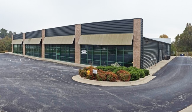
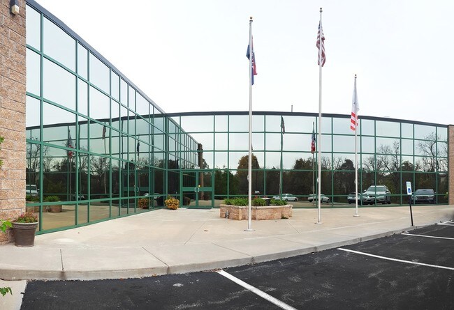
3880 W Battlefield St
18-05-400-297
6.79A M/L BEG SW COR NW1/4 SE1/4 5/28/22 E 103.89 FT NELY 1427.07 FT W TO NW COR SE1/4 S TO BEG (EX RDS) & (EX BEG NW COR LOT 8 SWLY 100.90 FT NWLY 51.94 FT TO CTR LN SOUTH CREEK
Medicalbuilding
Greene
AE
Missouri
29077C0336E
8
2025
6.79 AC
2025
Southwest
004202
Springfield
8,734 SF
Springfield, MO
DEMOGRAPHICS near 3880 W Battlefield St
1 Mile
3 Mile
5 Mile
2024 Total Population
5,740
49,919
130,161
2029 Population
5,868
51,791
135,143
Pop Growth 2024-2029
+ 2.23%
+ 3.75%
+ 3.83%
Average Age
41
39
38
2024 Total Households
2,425
21,444
56,343
HH Growth 2024-2029
+ 2.35%
+ 4.07%
+ 4.10%
Median Household Inc
$66,519
$55,291
$50,349
Avg Household Size
2.30
2.20
2.20
2024 Avg HH Vehicles
2.00
2.00
2.00
Median Home Value
$195,515
$175,745
$168,986
Median Year Built
1995
1994
1988
Nearby Places
Map Layers
Map Styles
 Street
 Aerial
- Restaurants
- Banks
- Shops
- Fitness
- Groceries
PUBLIC TRANSPORTATION
AIRPORT
Springfield-Branson Ntl
DRIVE
WALK
Distance
Springfield-Branson Ntl
22 min
9.8 mi
Freight Ports
Tulsa Port of Inola
DRIVE
WALK
Distance
Tulsa Port of Inola
187 min
168.6 mi
SALE & LEASE HISTORY
LISTING DATE
SALE/LEASE

Feb 21, 2017
For Sale
Nearby Properties
Address
Land Use
TOTAL SIZE
Lot Size
Zoning
Address
Land Use
TOTAL SIZE
Lot Size
Zoning
18.52 AC
INC
Address
Land Use
TOTAL SIZE
Lot Size
Zoning
22.64 AC
INC
Address
Land Use
TOTAL SIZE
Lot Size
Zoning
Address
Land Use
TOTAL SIZE
Lot Size
Zoning
312,092 SF
38 AC
INC
Address
Land Use
TOTAL SIZE
Lot Size
Zoning
614,588 SF
57.27 AC
INC
Address
Land Use
TOTAL SIZE
Lot Size
Zoning
129,652 SF
16.40 AC
INC
Address
Land Use
TOTAL SIZE
Lot Size
Zoning
334,594 SF
17.75 AC
INC
Address
Land Use
TOTAL SIZE
Lot Size
Zoning
9.82 AC
INC
Address
Land Use
TOTAL SIZE
Lot Size
Zoning
159,007 SF
16.05 AC
INC
Address
Land Use
TOTAL SIZE
Lot Size
Zoning
30,400 SF
9.05 AC
INC
Address
Land Use
TOTAL SIZE
Lot Size
Zoning
6.24 AC
INC
Address
Land Use
TOTAL SIZE
Lot Size
Zoning
65,208 SF
12.40 AC
INC
Address
Land Use
TOTAL SIZE
Lot Size
Zoning
12.81 AC
INC
Address
Land Use
TOTAL SIZE
Lot Size
Zoning
172,976 SF
5.99 AC
INC
Address
Land Use
TOTAL SIZE
Lot Size
Zoning
157,773 SF
18.55 AC
INC
Address
Land Use
TOTAL SIZE
Lot Size
Zoning
16.39 AC
INC
Address
Land Use
TOTAL SIZE
Lot Size
Zoning
8.26 AC
INC
Address
Land Use
TOTAL SIZE
Lot Size
Zoning
Address
Land Use
TOTAL SIZE
Lot Size
Zoning
10.58 AC
INC
Address
Land Use
TOTAL SIZE
Lot Size
Zoning
47,500 SF
5.24 AC
INC
Address
Land Use
TOTAL SIZE
Lot Size
Zoning
117,757 SF
6.50 AC
INC
Address
Land Use
TOTAL SIZE
Lot Size
Zoning
137,716 SF
11.08 AC
INC
Address
Land Use
TOTAL SIZE
Lot Size
Zoning
43,884 SF
2.42 AC
INC
Address
Land Use
TOTAL SIZE
Lot Size
Zoning
44,000 SF
3.05 AC
INC
Address
Land Use
TOTAL SIZE
Lot Size
Zoning
115,212 SF
6.70 AC
INC
Address
Land Use
TOTAL SIZE
Lot Size
Zoning
126,242 SF
4.75 AC
INC
Address
Land Use
TOTAL SIZE
Lot Size
Zoning
85,030 SF
8.89 AC
INC
Address
Land Use
TOTAL SIZE
Lot Size
Zoning
128,448 SF
4.30 AC
INC
Address
Land Use
TOTAL SIZE
Lot Size
Zoning
200,942 SF
15.70 AC
INC
Address
Land Use
TOTAL SIZE
Lot Size
Zoning
113,712 SF
11.10 AC
INC
The World's #1 Commercial Real Estate Marketplace
Connect with us
© 2026 CoStar Group
The information above has been obtained from sources believed reliable. While we do not doubt its accuracy we have not verified it and make no guarantee, warranty or representation about it. It is your responsibility to independently confirm its accuracy and completeness. Any projections, opinions, assumptions, or estimates used are for example only and do not represent the current or future performance of the property. The value of this transaction to you depends on tax and other factors which should be evaluated by your tax, financial, and legal advisors. You and your advisors should conduct a careful, independent investigation of the property to determine to your satisfaction the suitability of the property for your needs.