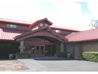
Property Record
3883 Highway 128, Geyserville, CA 95441

Save to a Folder
{{folder.Name}}
{{folder.ListingIds.length}} Properties
{{folder.ListingIds.length}} Property
Create a New Folder
Property Detail
3883 Highway 128
Santa Rosa-Petaluma, CA
2011 FM PTN 131-060-025 PM MNS 08-0020 LOT 1
131-060-029
Sonoma
Winery
California
AE The base floodplain where base flood elevations are provided. AE Zones are now used on new format FIRMs instead of A1-A30 Zones.
1
2025
35.80 AC
2025
Healdsburg/Cloverdale/N.
154100
North Bay/Santa Rosa
864 SF
NEARBY LISTINGS FOR SALE OR LEASE
-
-
View all Geyserville listings for sale on LoopNet.com
DEMOGRAPHICS near 3883 Highway 128
1 mile
3 mile
5 mile
2025 Total Population
83
740
9,497
2030 Population
78
734
9,558
Pop Growth 2025-2030
(6.02%)
(0.81%)
+ 0.64%
Average Age
47
49
46
2025 Total Households
31
295
3,627
HH Growth 2025-2030
(3.23%)
(0.68%)
+ 0.61%
Median Household Inc
$134,375
$136,111
$118,888
Avg Household Size
2.70
2.50
2.60
2025 Avg HH Vehicles
3.00
3.00
2.00
Median Home Value
$1,050,000
$1,084,091
$1,013,603
Median Year Built
1967
1972
1979
Nearby Places
Map Layers
Map Styles
 Street
 Aerial
Layers
 Traffic
 Biking
Places
Listings with unknown addresses are not visible on the map
- Restaurants
- Banks
- Shops
- Fitness
- Groceries
PUBLIC TRANSPORTATION
AIRPORT
Charles M Schulz - Sonoma County
Drive
Walk
Distance
Charles M Schulz - Sonoma County
29 min
19.5 mi
Freight Ports
Port of Richmond
Drive
Walk
Distance
Port of Richmond
94 min
72.4 mi
Nearby Properties
Address
Land Use
TOTAL SIZE
Lot Size
Zoning
Address
Land Use
TOTAL SIZE
Lot Size
Zoning
87.32 AC
Address
Land Use
TOTAL SIZE
Lot Size
Zoning
219,180 SF
0.15 AC
LIA20
Address
Land Use
TOTAL SIZE
Lot Size
Zoning
6,819 SF
115.66 AC
LIA20
Address
Land Use
TOTAL SIZE
Lot Size
Zoning
Address
Land Use
TOTAL SIZE
Lot Size
Zoning
507.59 AC
Address
Land Use
TOTAL SIZE
Lot Size
Zoning
0.15 AC
DA10
Address
Land Use
TOTAL SIZE
Lot Size
Zoning
1,091 SF
362.51 AC
Address
Land Use
TOTAL SIZE
Lot Size
Zoning
19,893 SF
48.66 AC
Address
Land Use
TOTAL SIZE
Lot Size
Zoning
60,820 SF
45.87 AC
LIA20
Address
Land Use
TOTAL SIZE
Lot Size
Zoning
294 SF
18 AC
LIA20
Address
Land Use
TOTAL SIZE
Lot Size
Zoning
40,000 SF
21.85 AC
LIA20
Address
Land Use
TOTAL SIZE
Lot Size
Zoning
1,888 SF
268.03 AC
LIA20
Address
Land Use
TOTAL SIZE
Lot Size
Zoning
4,643 SF
26 AC
LIA20
Address
Land Use
TOTAL SIZE
Lot Size
Zoning
197.63 AC
Address
Land Use
TOTAL SIZE
Lot Size
Zoning
8,344 SF
200 AC
LEA240
Address
Land Use
TOTAL SIZE
Lot Size
Zoning
2,650 SF
18.15 AC
Address
Land Use
TOTAL SIZE
Lot Size
Zoning
633 AC
LEA240
Address
Land Use
TOTAL SIZE
Lot Size
Zoning
6,128 SF
310 AC
LIA20
Address
Land Use
TOTAL SIZE
Lot Size
Zoning
7.27 AC
LIA20
Address
Land Use
TOTAL SIZE
Lot Size
Zoning
32.12 AC
Address
Land Use
TOTAL SIZE
Lot Size
Zoning
4,562 SF
32.81 AC
Address
Land Use
TOTAL SIZE
Lot Size
Zoning
6,925 SF
10.42 AC
Address
Land Use
TOTAL SIZE
Lot Size
Zoning
2,438 SF
122.59 AC
LIA20
Address
Land Use
TOTAL SIZE
Lot Size
Zoning
7,281 SF
384 AC
Address
Land Use
TOTAL SIZE
Lot Size
Zoning
3,173 SF
20.01 AC
LIA20
Address
Land Use
TOTAL SIZE
Lot Size
Zoning
8,117 SF
0.16 AC
LEA240
Address
Land Use
TOTAL SIZE
Lot Size
Zoning
10,115 SF
75.55 AC
LEA240
Address
Land Use
TOTAL SIZE
Lot Size
Zoning
40.82 AC
Address
Land Use
TOTAL SIZE
Lot Size
Zoning
2,006 SF
541.71 AC
LEA240
The World's #1 Commercial Real Estate Marketplace
Connect with us
© 2026 CoStar Group
The information above has been obtained from sources believed reliable. While we do not doubt its accuracy we have not verified it and make no guarantee, warranty or representation about it. It is your responsibility to independently confirm its accuracy and completeness. Any projections, opinions, assumptions, or estimates used are for example only and do not represent the current or future performance of the property. The value of this transaction to you depends on tax and other factors which should be evaluated by your tax, financial, and legal advisors. You and your advisors should conduct a careful, independent investigation of the property to determine to your satisfaction the suitability of the property for your needs.