Property Record
3884 Route 115, Blakeslee, PA 18610
NEARBY LISTINGS FOR SALE OR LEASE
-
-
View all Blakeslee listings for sale on LoopNet.com
Property Detail
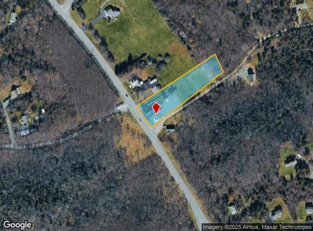
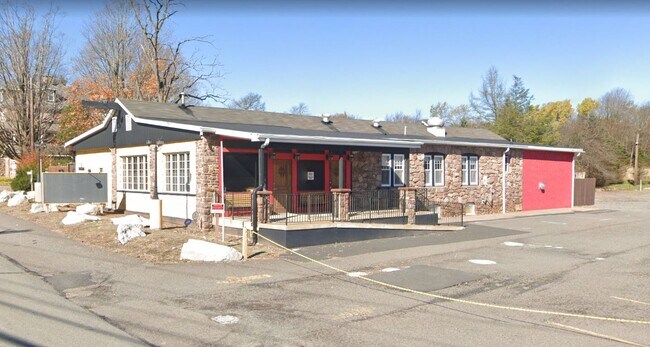
3884 Route 115
20.8.1.1-4
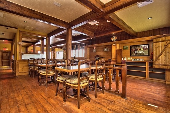
Villa Virella
Restaurantbuilding
PADDY KENNY'S IRSH PUB
X
Monroe
42089C0240E
Pennsylvania
2025
1.50 AC
2025
Monroe County
300316
Philadelphia
7,426 SF
East Stroudsburg, PA
DEMOGRAPHICS near 3884 Route 115
1 Mile
3 Mile
5 Mile
2024 Total Population
2,093
11,953
24,049
2029 Population
2,082
12,147
24,418
Pop Growth 2024-2029
(0.53%)
+ 1.62%
+ 1.53%
Average Age
42
41
42
2024 Total Households
769
4,363
8,766
HH Growth 2024-2029
(0.52%)
+ 1.63%
+ 1.52%
Median Household Inc
$71,707
$69,791
$73,226
Avg Household Size
2.70
2.70
2.70
2024 Avg HH Vehicles
2.00
2.00
2.00
Median Home Value
$187,728
$204,143
$201,762
Median Year Built
1987
1990
1989
Nearby Places
- Restaurants
- Banks
- Shops
- Fitness
- Groceries
PUBLIC TRANSPORTATION
AIRPORT
Lehigh Valley International
DRIVE
WALK
Distance
Lehigh Valley International
56 min
35.1 mi
Wilkes-Barre/Scranton International
DRIVE
WALK
Distance
Wilkes-Barre/Scranton International
52 min
38.6 mi
Freight Ports
Maher Terminal
DRIVE
WALK
Distance
Maher Terminal
122 min
91.9 mi
SALE & LEASE HISTORY
LISTING DATE
SALE/LEASE

Sep 24, 2016
For Sale
Mar 09, 2020
For Sale
Mar 05, 2020
For Sale
Jul 26, 2017
For Lease
Nearby Properties
Address
Land Use
TOTAL SIZE
Lot Size
Zoning
Address
Land Use
TOTAL SIZE
Lot Size
Zoning
1,380 SF
1,624.22 AC
OS-W
Address
Land Use
TOTAL SIZE
Lot Size
Zoning
6,540 SF
3.54 AC
GC
Address
Land Use
TOTAL SIZE
Lot Size
Zoning
24,000 SF
8.32 AC
CI
Address
Land Use
TOTAL SIZE
Lot Size
Zoning
9,360 SF
2 AC
GC
Address
Land Use
TOTAL SIZE
Lot Size
Zoning
320 AC
C-2
Address
Land Use
TOTAL SIZE
Lot Size
Zoning
7,634 SF
32.89 AC
C-2
Address
Land Use
TOTAL SIZE
Lot Size
Zoning
13,020 SF
1 AC
GC
Address
Land Use
TOTAL SIZE
Lot Size
Zoning
6,424 SF
1.74 AC
C-1
Address
Land Use
TOTAL SIZE
Lot Size
Zoning
367 AC
OS-W
Address
Land Use
TOTAL SIZE
Lot Size
Zoning
12,938 SF
3 AC
GC
Address
Land Use
TOTAL SIZE
Lot Size
Zoning
394.78 AC
R-1
Address
Land Use
TOTAL SIZE
Lot Size
Zoning
355.92 AC
OS-W
Address
Land Use
TOTAL SIZE
Lot Size
Zoning
6,056 SF
88.86 AC
CIA
Address
Land Use
TOTAL SIZE
Lot Size
Zoning
7,500 SF
2.91 AC
C-1
Address
Land Use
TOTAL SIZE
Lot Size
Zoning
7,284 SF
4.44 AC
R-1
Address
Land Use
TOTAL SIZE
Lot Size
Zoning
5,376 SF
16.70 AC
GC
Address
Land Use
TOTAL SIZE
Lot Size
Zoning
12.76 AC
R-1
Address
Land Use
TOTAL SIZE
Lot Size
Zoning
98.18 AC
OS-W
Address
Land Use
TOTAL SIZE
Lot Size
Zoning
8,300 SF
5.44 AC
GC
Address
Land Use
TOTAL SIZE
Lot Size
Zoning
9,000 SF
0.55 AC
GC
Address
Land Use
TOTAL SIZE
Lot Size
Zoning
7,580 SF
52.46 AC
R-1
Address
Land Use
TOTAL SIZE
Lot Size
Zoning
3,828 SF
65.15 AC
OS-W
Address
Land Use
TOTAL SIZE
Lot Size
Zoning
149.38 AC
R-1
Address
Land Use
TOTAL SIZE
Lot Size
Zoning
7,426 SF
1.50 AC
C-1
Address
Land Use
TOTAL SIZE
Lot Size
Zoning
4,364 SF
1 AC
GC
Address
Land Use
TOTAL SIZE
Lot Size
Zoning
7,802 SF
2.61 AC
GC
Address
Land Use
TOTAL SIZE
Lot Size
Zoning
3,340 SF
0.76 AC
C-1
Address
Land Use
TOTAL SIZE
Lot Size
Zoning
86.54 AC
C-2
Address
Land Use
TOTAL SIZE
Lot Size
Zoning
2,352 SF
1.02 AC
GC
Address
Land Use
TOTAL SIZE
Lot Size
Zoning
6,560 SF
0.23 AC
R-S
The World's #1 Commercial Real Estate Marketplace
Connect with us
© 2025 CoStar Group
The information above has been obtained from sources believed reliable. While we do not doubt its accuracy we have not verified it and make no guarantee, warranty or representation about it. It is your responsibility to independently confirm its accuracy and completeness. Any projections, opinions, assumptions, or estimates used are for example only and do not represent the current or future performance of the property. The value of this transaction to you depends on tax and other factors which should be evaluated by your tax, financial, and legal advisors. You and your advisors should conduct a careful, independent investigation of the property to determine to your satisfaction the suitability of the property for your needs.