Property Record
389 1St St, Los Altos, CA 94022
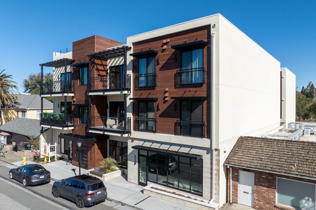
This Property Is For Sale
NEARBY LISTINGS FOR SALE OR LEASE
Property Detail
389 1St St
South Bay/San Jose
Santa Clara
San Jose-Sunnyvale-Santa Clara, CA
California
167-65-031
0.02 AC
Condominium
North Los Altos
1,331 SF
DEMOGRAPHICS near 389 1St St
1 Mile
3 Mile
5 Mile
2024 Total Population
10,201
119,008
277,268
2029 Population
9,828
115,855
269,334
Pop Growth 2024-2029
(3.66%)
(2.65%)
(2.86%)
Average Age
45
41
40
2024 Total Households
3,621
46,646
102,910
HH Growth 2024-2029
(3.92%)
(2.75%)
(2.94%)
Median Household Inc
$239,138
$195,527
$187,991
Avg Household Size
2.80
2.50
2.50
2024 Avg HH Vehicles
2.00
2.00
2.00
Median Home Value
$1,145,983
$1,139,337
$1,138,104
Median Year Built
1963
1970
1971
Nearby Places
Map Layers
Map Styles
 Street
 Aerial
- Restaurants
- Banks
- Shops
- Fitness
- Groceries
PUBLIC TRANSPORTATION
COMMUTER RAIL
San Antonio (Caltrain - Caltrain (Caltrain))
DRIVE
WALK
Distance
San Antonio (Caltrain - Caltrain (Caltrain))
6 min
2.5 mi
DRIVE
WALK
Distance
10 min
3.3 mi
AIRPORT
Norman Y Mineta San Jose International
DRIVE
WALK
Distance
Norman Y Mineta San Jose International
21 min
12.2 mi
San Francisco International
DRIVE
WALK
Distance
San Francisco International
37 min
26.1 mi
Metro Oakland International
DRIVE
WALK
Distance
Metro Oakland International
50 min
34.8 mi
Freight Ports
Port of Redwood City
DRIVE
WALK
Distance
Port of Redwood City
22 min
13.0 mi
Nearby Properties
Address
Land Use
TOTAL SIZE
Lot Size
Zoning
Address
Land Use
TOTAL SIZE
Lot Size
Zoning
42.28 AC
PF
Address
Land Use
TOTAL SIZE
Lot Size
Zoning
0.33 AC
PF
Address
Land Use
TOTAL SIZE
Lot Size
Zoning
450,575 SF
3.73 AC
P(9)
Address
Land Use
TOTAL SIZE
Lot Size
Zoning
78,277 SF
16.31 AC
RP
Address
Land Use
TOTAL SIZE
Lot Size
Zoning
584,389 SF
5.25 AC
P(40)
Address
Land Use
TOTAL SIZE
Lot Size
Zoning
595,000 SF
7.42 AC
P(34)
Address
Land Use
TOTAL SIZE
Lot Size
Zoning
675,100 SF
52.78 AC
RP5
Address
Land Use
TOTAL SIZE
Lot Size
Zoning
233,124 SF
9.18 AC
P(7)
Address
Land Use
TOTAL SIZE
Lot Size
Zoning
458,842 SF
26.64 AC
RP5
Address
Land Use
TOTAL SIZE
Lot Size
Zoning
372,859 SF
4.71 AC
P
Address
Land Use
TOTAL SIZE
Lot Size
Zoning
298,463 SF
7 AC
P(19)
Address
Land Use
TOTAL SIZE
Lot Size
Zoning
640,105 SF
7.90 AC
R3-2*
Address
Land Use
TOTAL SIZE
Lot Size
Zoning
322,264 SF
3.92 AC
P
Address
Land Use
TOTAL SIZE
Lot Size
Zoning
208.82 AC
MV
Address
Land Use
TOTAL SIZE
Lot Size
Zoning
110,384 SF
10.17 AC
RP
Address
Land Use
TOTAL SIZE
Lot Size
Zoning
89,237 SF
5.51 AC
P(9)
Address
Land Use
TOTAL SIZE
Lot Size
Zoning
224,086 SF
10.80 AC
R3-1.
Address
Land Use
TOTAL SIZE
Lot Size
Zoning
2.90 AC
P(17)
Address
Land Use
TOTAL SIZE
Lot Size
Zoning
162,552 SF
9.78 AC
R3-2*
Address
Land Use
TOTAL SIZE
Lot Size
Zoning
35,926 SF
6.50 AC
RP5
Address
Land Use
TOTAL SIZE
Lot Size
Zoning
96,579 SF
1.21 AC
P(19)
Address
Land Use
TOTAL SIZE
Lot Size
Zoning
186,490 SF
2.43 AC
CRA
Address
Land Use
TOTAL SIZE
Lot Size
Zoning
114,809 SF
3.94 AC
P18
Address
Land Use
TOTAL SIZE
Lot Size
Zoning
227,390 SF
2.28 AC
P(38)
Address
Land Use
TOTAL SIZE
Lot Size
Zoning
207,857 SF
16.34 AC
RP-5D
Address
Land Use
TOTAL SIZE
Lot Size
Zoning
299,882 SF
2.62 AC
P38
Address
Land Use
TOTAL SIZE
Lot Size
Zoning
8,400 SF
3.46 AC
P(7)
Address
Land Use
TOTAL SIZE
Lot Size
Zoning
196,167 SF
4.50 AC
RP
Address
Land Use
TOTAL SIZE
Lot Size
Zoning
63,000 SF
9.34 AC
LM
Address
Land Use
TOTAL SIZE
Lot Size
Zoning
233,098 SF
2.91 AC
APD
The World's #1 Commercial Real Estate Marketplace
Connect with us
© 2026 CoStar Group
The information above has been obtained from sources believed reliable. While we do not doubt its accuracy we have not verified it and make no guarantee, warranty or representation about it. It is your responsibility to independently confirm its accuracy and completeness. Any projections, opinions, assumptions, or estimates used are for example only and do not represent the current or future performance of the property. The value of this transaction to you depends on tax and other factors which should be evaluated by your tax, financial, and legal advisors. You and your advisors should conduct a careful, independent investigation of the property to determine to your satisfaction the suitability of the property for your needs.