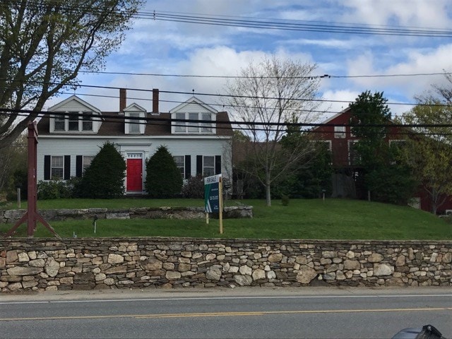
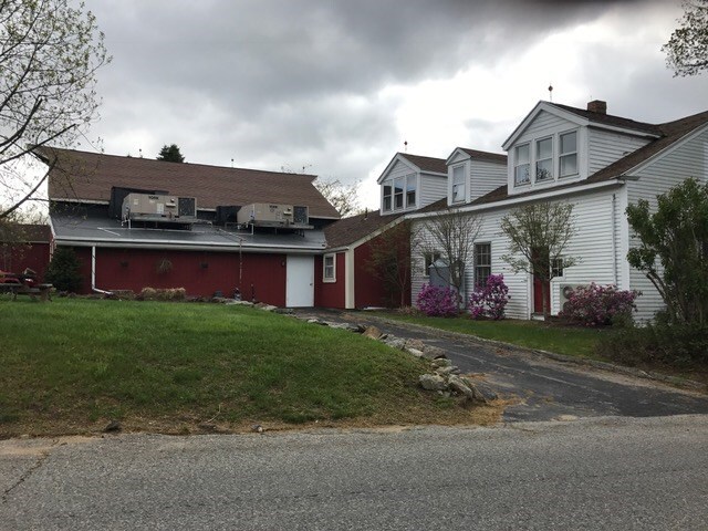
Property Record
389 Main St, Spencer, MA 01562

Save to a Folder
{{folder.Name}}
{{folder.ListingIds.length}} Properties
{{folder.ListingIds.length}} Property
Create a New Folder
Property Detail
389 Main St
SPEN-000035R-000027
Worcester
Departmentstore
Massachusetts
B and X Area of moderate flood hazard, usually the area between the limits of the 100-year and 500-year floods.
1.85 AC
2025
Outlying Worcester
2025
Boston
726100
Worcester, MA
3,644 SF
NEARBY LISTINGS FOR SALE OR LEASE
DEMOGRAPHICS near 389 Main St
1 mile
3 mile
5 mile
2025 Total Population
1,222
13,625
28,979
2030 Population
1,281
13,973
29,732
Pop Growth 2025-2030
+ 4.83%
+ 2.55%
+ 2.60%
Average Age
44
43
43
2025 Total Households
493
5,736
11,375
HH Growth 2025-2030
+ 5.07%
+ 2.60%
+ 2.67%
Median Household Inc
$100,329
$81,256
$92,635
Avg Household Size
2.40
2.30
2.50
2025 Avg HH Vehicles
2.00
2.00
2.00
Median Home Value
$434,883
$412,654
$427,189
Median Year Built
1976
1968
1969
Nearby Places
Map Layers
Map Styles
 Street
 Aerial
Layers
 Traffic
 Biking
Places
Listings with unknown addresses are not visible on the map
- Restaurants
- Banks
- Shops
- Fitness
- Groceries
PUBLIC TRANSPORTATION
COMMUTER RAIL
Drive
Walk
Distance
20 min
9.9 mi
AIRPORT
Worcester Regional
Drive
Walk
Distance
Worcester Regional
19 min
8.4 mi
Freight Ports
Port of Boston
Drive
Walk
Distance
Port of Boston
80 min
55.2 mi
SALE & LEASE HISTORY
LISTING DATE
SALE/LEASE

May 10, 2017
For Sale
Nearby Properties
Address
Land Use
TOTAL SIZE
Lot Size
Zoning
Address
Land Use
TOTAL SIZE
Lot Size
Zoning
78,309 SF
33.51 AC
Address
Land Use
TOTAL SIZE
Lot Size
Zoning
1,408 SF
42.06 AC
HB1
Address
Land Use
TOTAL SIZE
Lot Size
Zoning
141,180 SF
29.33 AC
Address
Land Use
TOTAL SIZE
Lot Size
Zoning
78,145 SF
20.75 AC
Address
Land Use
TOTAL SIZE
Lot Size
Zoning
206,992 SF
55.33 AC
HB1
Address
Land Use
TOTAL SIZE
Lot Size
Zoning
68,052 SF
44 AC
Address
Land Use
TOTAL SIZE
Lot Size
Zoning
3,576 SF
13 AC
Address
Land Use
TOTAL SIZE
Lot Size
Zoning
17 AC
HB1
Address
Land Use
TOTAL SIZE
Lot Size
Zoning
81,001 SF
11 AC
Address
Land Use
TOTAL SIZE
Lot Size
Zoning
9.40 AC
HB1
Address
Land Use
TOTAL SIZE
Lot Size
Zoning
39,660 SF
1.28 AC
Address
Land Use
TOTAL SIZE
Lot Size
Zoning
59,508 SF
1.84 AC
Address
Land Use
TOTAL SIZE
Lot Size
Zoning
18,970 SF
1.91 AC
R2
Address
Land Use
TOTAL SIZE
Lot Size
Zoning
1,092 SF
35.26 AC
Address
Land Use
TOTAL SIZE
Lot Size
Zoning
16,444 SF
0.93 AC
CB
Address
Land Use
TOTAL SIZE
Lot Size
Zoning
329.37 AC
HB1
Address
Land Use
TOTAL SIZE
Lot Size
Zoning
6.86 AC
HB1
Address
Land Use
TOTAL SIZE
Lot Size
Zoning
44,769 SF
22.40 AC
Address
Land Use
TOTAL SIZE
Lot Size
Zoning
14,690 SF
5.47 AC
Address
Land Use
TOTAL SIZE
Lot Size
Zoning
4,070 SF
7.59 AC
Address
Land Use
TOTAL SIZE
Lot Size
Zoning
21,770 SF
4.34 AC
Address
Land Use
TOTAL SIZE
Lot Size
Zoning
6,656 SF
2.26 AC
Address
Land Use
TOTAL SIZE
Lot Size
Zoning
23,296 SF
2.35 AC
R2
Address
Land Use
TOTAL SIZE
Lot Size
Zoning
31.58 AC
SA
Address
Land Use
TOTAL SIZE
Lot Size
Zoning
4,285 SF
0.98 AC
Address
Land Use
TOTAL SIZE
Lot Size
Zoning
262.02 AC
OR4
Address
Land Use
TOTAL SIZE
Lot Size
Zoning
18,628 SF
1.17 AC
Address
Land Use
TOTAL SIZE
Lot Size
Zoning
24,090 SF
0.31 AC
CB
Address
Land Use
TOTAL SIZE
Lot Size
Zoning
19,116 SF
0.46 AC
CB
Address
Land Use
TOTAL SIZE
Lot Size
Zoning
1.50 AC
CB
The World's #1 Commercial Real Estate Marketplace
Connect with us
© 2026 CoStar Group
The information above has been obtained from sources believed reliable. While we do not doubt its accuracy we have not verified it and make no guarantee, warranty or representation about it. It is your responsibility to independently confirm its accuracy and completeness. Any projections, opinions, assumptions, or estimates used are for example only and do not represent the current or future performance of the property. The value of this transaction to you depends on tax and other factors which should be evaluated by your tax, financial, and legal advisors. You and your advisors should conduct a careful, independent investigation of the property to determine to your satisfaction the suitability of the property for your needs.