Property Record
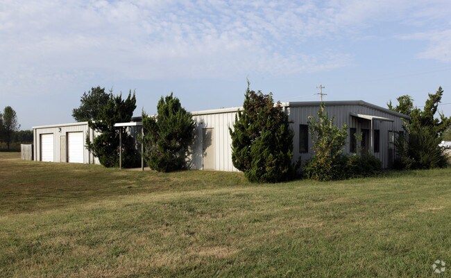
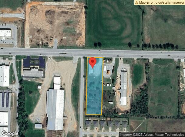
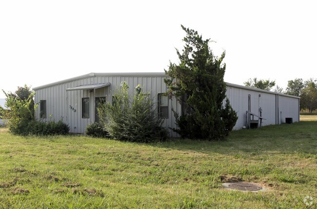
3890 Highway 412 E, Siloam Springs, AR 72761
NEARBY LISTINGS FOR SALE OR LEASE
Property Detail
3890 Highway 412 E
03-04350-000
Siloam Springs
Officebuilding
THE NE 1/4 OF THE NW 1/4 OF THE SE 1/4 OF SECTION 4, TOWNSHIP 17 NORTH, RANGE 33 WEST, BENTON COUNTY, ARKANSAS. SUBJECT TO U.S. HIGHWAY 412 (FORMERLY STATE HIGHWAY 68). LESS AND EXCEPT PART OF THE NW 1/4 OF THE SE 1/4 OF SECTION 4, TOWNSHIP 17 NORTH,
X
Benton
40041C0600E
Arkansas
2025
2.23 AC
2025
Outlying Benton County
021313
Fayetteville/Springdale/Rogers
3,840 SF
Fayetteville-Springdale-Rogers, AR-MO
DEMOGRAPHICS near 3890 Highway 412 E
1 Mile
3 Mile
5 Mile
2024 Total Population
2,546
18,859
26,452
2029 Population
3,025
22,248
31,064
Pop Growth 2024-2029
+ 18.81%
+ 17.97%
+ 17.44%
Average Age
36
36
37
2024 Total Households
938
6,633
9,162
HH Growth 2024-2029
+ 18.66%
+ 18.00%
+ 17.47%
Median Household Inc
$58,799
$60,154
$62,192
Avg Household Size
2.60
2.70
2.70
2024 Avg HH Vehicles
2.00
2.00
2.00
Median Home Value
$231,896
$193,775
$199,878
Median Year Built
1994
1993
1992
Nearby Places
Map Layers
Map Styles
 Street
 Aerial
- Restaurants
- Banks
- Shops
- Fitness
- Groceries
PUBLIC TRANSPORTATION
AIRPORT
Northwest Arkansas Ntl
DRIVE
WALK
Distance
Northwest Arkansas Ntl
32 min
21.0 mi
Nearby Properties
Address
Land Use
TOTAL SIZE
Lot Size
Zoning
Address
Land Use
TOTAL SIZE
Lot Size
Zoning
85,903 SF
10 AC
Address
Land Use
TOTAL SIZE
Lot Size
Zoning
91,795 SF
Address
Land Use
TOTAL SIZE
Lot Size
Zoning
140,452 SF
9.28 AC
Address
Land Use
TOTAL SIZE
Lot Size
Zoning
183,822 SF
23.62 AC
Address
Land Use
TOTAL SIZE
Lot Size
Zoning
190,712 SF
15.73 AC
Address
Land Use
TOTAL SIZE
Lot Size
Zoning
119,258 SF
16.25 AC
Address
Land Use
TOTAL SIZE
Lot Size
Zoning
283,200 SF
39.14 AC
Address
Land Use
TOTAL SIZE
Lot Size
Zoning
398,700 SF
61.85 AC
Address
Land Use
TOTAL SIZE
Lot Size
Zoning
30,542 SF
66.48 AC
Address
Land Use
TOTAL SIZE
Lot Size
Zoning
190,790 SF
25.17 AC
Address
Land Use
TOTAL SIZE
Lot Size
Zoning
422,489 SF
57.90 AC
Address
Land Use
TOTAL SIZE
Lot Size
Zoning
110,904 SF
15.22 AC
Address
Land Use
TOTAL SIZE
Lot Size
Zoning
53,387 SF
18.61 AC
Address
Land Use
TOTAL SIZE
Lot Size
Zoning
264,685 SF
14.13 AC
Address
Land Use
TOTAL SIZE
Lot Size
Zoning
23,133 SF
3 AC
Address
Land Use
TOTAL SIZE
Lot Size
Zoning
31,887 SF
1.61 AC
Address
Land Use
TOTAL SIZE
Lot Size
Zoning
193,871 SF
39.98 AC
Address
Land Use
TOTAL SIZE
Lot Size
Zoning
98,492 SF
6.33 AC
Address
Land Use
TOTAL SIZE
Lot Size
Zoning
77,210 SF
5 AC
Address
Land Use
TOTAL SIZE
Lot Size
Zoning
20,475 SF
19.62 AC
Address
Land Use
TOTAL SIZE
Lot Size
Zoning
21,974 SF
3.87 AC
Address
Land Use
TOTAL SIZE
Lot Size
Zoning
92,300 SF
6.35 AC
Address
Land Use
TOTAL SIZE
Lot Size
Zoning
144,166 SF
12.49 AC
Address
Land Use
TOTAL SIZE
Lot Size
Zoning
87,684 SF
5.43 AC
Address
Land Use
TOTAL SIZE
Lot Size
Zoning
36,185 SF
0.78 AC
Address
Land Use
TOTAL SIZE
Lot Size
Zoning
57,502 SF
7.08 AC
Address
Land Use
TOTAL SIZE
Lot Size
Zoning
6,547 SF
5.48 AC
Address
Land Use
TOTAL SIZE
Lot Size
Zoning
40,709 SF
4.24 AC
Address
Land Use
TOTAL SIZE
Lot Size
Zoning
61,560 SF
9.33 AC
Address
Land Use
TOTAL SIZE
Lot Size
Zoning
63,439 SF
5.17 AC
The World's #1 Commercial Real Estate Marketplace
Connect with us
© 2026 CoStar Group
The information above has been obtained from sources believed reliable. While we do not doubt its accuracy we have not verified it and make no guarantee, warranty or representation about it. It is your responsibility to independently confirm its accuracy and completeness. Any projections, opinions, assumptions, or estimates used are for example only and do not represent the current or future performance of the property. The value of this transaction to you depends on tax and other factors which should be evaluated by your tax, financial, and legal advisors. You and your advisors should conduct a careful, independent investigation of the property to determine to your satisfaction the suitability of the property for your needs.