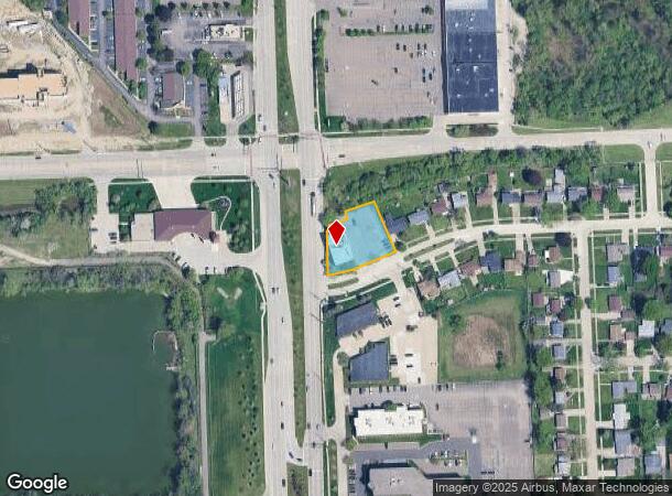
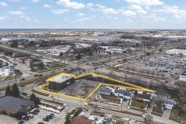
Property Record
38900 Van Dyke Ave, Sterling Heights, MI 48312
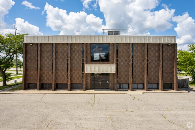
This Property Is For Sale
NEARBY LISTINGS FOR SALE OR LEASE
Property Detail
38900 Van Dyke Ave
10-10-22-101-003
M 523A2B5 $T2N,R12E SEC 22 COMM AT NW COR SEC 22; TH S01*04'30"W 172.30 FT; TH N73*37'21"E 62.90 FT TO PT OF BEG; TH
Officebuilding
Macomb
X
Michigan
26099C0309G
0.65 AC
2025
Macomb West
2025
Detroit
231200
Detroit-Warren-Dearborn, MI
12,000 SF
DEMOGRAPHICS near 38900 Van Dyke Ave
1 Mile
3 Mile
5 Mile
2024 Total Population
7,910
96,119
270,093
2029 Population
7,774
94,628
266,964
Pop Growth 2024-2029
(1.72%)
(1.55%)
(1.16%)
Average Age
41
42
43
2024 Total Households
3,305
35,772
108,211
HH Growth 2024-2029
(1.85%)
(1.60%)
(1.17%)
Median Household Inc
$68,375
$73,066
$71,604
Avg Household Size
2.40
2.60
2.40
2024 Avg HH Vehicles
2.00
2.00
2.00
Median Home Value
$210,103
$237,119
$231,593
Median Year Built
1968
1975
1976
Nearby Places
Map Layers
Map Styles
 Street
 Aerial
- Restaurants
- Banks
- Shops
- Fitness
- Groceries
PUBLIC TRANSPORTATION
AIRPORT
Windsor International
DRIVE
WALK
Distance
Windsor International
55 min
32.4 mi
Detroit Metro Wayne County
DRIVE
WALK
Distance
Detroit Metro Wayne County
60 min
41.9 mi
Nearby Properties
Address
Land Use
TOTAL SIZE
Lot Size
Zoning
Address
Land Use
TOTAL SIZE
Lot Size
Zoning
920,611 SF
M-2
Address
Land Use
TOTAL SIZE
Lot Size
Zoning
1,024,233 SF
287.20 AC
M-2
Address
Land Use
TOTAL SIZE
Lot Size
Zoning
2,726,159 SF
199.39 AC
M-2
Address
Land Use
TOTAL SIZE
Lot Size
Zoning
146.36 AC
MHP
Address
Land Use
TOTAL SIZE
Lot Size
Zoning
569,813 SF
62.54 AC
M-2
Address
Land Use
TOTAL SIZE
Lot Size
Zoning
2,727,131 SF
155.26 AC
M-2
Address
Land Use
TOTAL SIZE
Lot Size
Zoning
92.30 AC
MHP
Address
Land Use
TOTAL SIZE
Lot Size
Zoning
2,058,062 SF
141.65 AC
M-2
Address
Land Use
TOTAL SIZE
Lot Size
Zoning
226,380 SF
46.45 AC
M-1
Address
Land Use
TOTAL SIZE
Lot Size
Zoning
283,249 SF
M-2
Address
Land Use
TOTAL SIZE
Lot Size
Zoning
229,624 SF
13.55 AC
M-2
Address
Land Use
TOTAL SIZE
Lot Size
Zoning
2,984,492 SF
M-2
Address
Land Use
TOTAL SIZE
Lot Size
Zoning
423,027 SF
46.73 AC
M-1
Address
Land Use
TOTAL SIZE
Lot Size
Zoning
25.18 AC
RM-2
Address
Land Use
TOTAL SIZE
Lot Size
Zoning
98,265 SF
7.04 AC
RM-2
Address
Land Use
TOTAL SIZE
Lot Size
Zoning
201,873 SF
M-1
Address
Land Use
TOTAL SIZE
Lot Size
Zoning
559,929 SF
41.57 AC
M-1
Address
Land Use
TOTAL SIZE
Lot Size
Zoning
148,330 SF
37.86 AC
RM-2
Address
Land Use
TOTAL SIZE
Lot Size
Zoning
135,274 SF
20.55 AC
RM-2
Address
Land Use
TOTAL SIZE
Lot Size
Zoning
139,846 SF
16 AC
RM-2
Address
Land Use
TOTAL SIZE
Lot Size
Zoning
210,000 SF
M-1
Address
Land Use
TOTAL SIZE
Lot Size
Zoning
159,750 SF
16.76 AC
M-1
Address
Land Use
TOTAL SIZE
Lot Size
Zoning
16.11 AC
RM-2
Address
Land Use
TOTAL SIZE
Lot Size
Zoning
219,437 SF
18.80 AC
PCD
Address
Land Use
TOTAL SIZE
Lot Size
Zoning
554,374 SF
22.15 AC
M-2
Address
Land Use
TOTAL SIZE
Lot Size
Zoning
200,000 SF
17.66 AC
M-2
Address
Land Use
TOTAL SIZE
Lot Size
Zoning
21.03 AC
RM-2
Address
Land Use
TOTAL SIZE
Lot Size
Zoning
210,080 SF
14.35 AC
RM-2
Address
Land Use
TOTAL SIZE
Lot Size
Zoning
207,424 SF
11.96 AC
RM-2
Address
Land Use
TOTAL SIZE
Lot Size
Zoning
118,890 SF
2.51 AC
C-3
The World's #1 Commercial Real Estate Marketplace
Connect with us
© 2026 CoStar Group
The information above has been obtained from sources believed reliable. While we do not doubt its accuracy we have not verified it and make no guarantee, warranty or representation about it. It is your responsibility to independently confirm its accuracy and completeness. Any projections, opinions, assumptions, or estimates used are for example only and do not represent the current or future performance of the property. The value of this transaction to you depends on tax and other factors which should be evaluated by your tax, financial, and legal advisors. You and your advisors should conduct a careful, independent investigation of the property to determine to your satisfaction the suitability of the property for your needs.