Property Record
3891 S Highway 55 S, Jackson, MS 39212
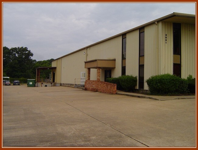


Property Detail
3891 S Highway 55 S
Jackson, MS
BEG INT N/L STOKES ROBERTSON ROAD & W/L INT HWY 55 NE 224.39 FT TO POB W 241.33 FT N 328. 9 FT E 104.2 FT S 228.5 FT E 2 220.2 S 133.4 FT TO POB BEING A PART LOT 8 & 9 THE MEADOWS SUBN
0862-0076-000
HINDS
Charitableorganization
Mississippi
AE The base floodplain where base flood elevations are provided. AE Zones are now used on new format FIRMs instead of A1-A30 Zones.
8-9
2024
1 AC
2025
North Jackson
003800
Jackson
9,900 SF
NEARBY LISTINGS FOR SALE OR LEASE
-
-
View all Jackson listings for sale on LoopNet.com
DEMOGRAPHICS near 3891 S Highway 55 S
1 mile
3 mile
5 mile
2025 Total Population
4,674
46,901
98,642
2030 Population
4,440
45,335
96,297
Pop Growth 2025-2030
(5.01%)
(3.34%)
(2.38%)
Average Age
40
40
39
2025 Total Households
2,244
21,077
42,654
HH Growth 2025-2030
(5.35%)
(3.51%)
(2.53%)
Median Household Inc
$77,196
$46,889
$44,521
Avg Household Size
2.00
2.10
2.20
2025 Avg HH Vehicles
2.00
2.00
2.00
Median Home Value
$281,024
$163,819
$141,186
Median Year Built
1963
1965
1969
Nearby Places
Map Layers
Map Styles
 Street
 Aerial
Layers
 Traffic
 Biking
Places
Listings with unknown addresses are not visible on the map
- Restaurants
- Banks
- Shops
- Fitness
- Groceries
PUBLIC TRANSPORTATION
COMMUTER RAIL
Jackson (City of New Orleans - Amtrak)
Drive
Walk
Distance
Jackson (City of New Orleans - Amtrak)
9 min
5.2 mi
AIRPORT
Jackson-Medgar Wiley Evers International
Drive
Walk
Distance
Jackson-Medgar Wiley Evers International
22 min
13.8 mi
Freight Ports
Port of Greater Baton Rouge
Drive
Walk
Distance
Port of Greater Baton Rouge
190 min
171.5 mi
Nearby Properties
Address
Land Use
TOTAL SIZE
Lot Size
Zoning
Address
Land Use
TOTAL SIZE
Lot Size
Zoning
22,109 SF
1 AC
Address
Land Use
TOTAL SIZE
Lot Size
Zoning
224,684 SF
18 AC
Address
Land Use
TOTAL SIZE
Lot Size
Zoning
8.90 AC
Address
Land Use
TOTAL SIZE
Lot Size
Zoning
16,665 SF
1 AC
Address
Land Use
TOTAL SIZE
Lot Size
Zoning
Address
Land Use
TOTAL SIZE
Lot Size
Zoning
111,460 SF
9 AC
Address
Land Use
TOTAL SIZE
Lot Size
Zoning
28.48 AC
Address
Land Use
TOTAL SIZE
Lot Size
Zoning
14,075 SF
3.86 AC
Address
Land Use
TOTAL SIZE
Lot Size
Zoning
4,810 SF
28.82 AC
Address
Land Use
TOTAL SIZE
Lot Size
Zoning
18,881 SF
16.06 AC
Address
Land Use
TOTAL SIZE
Lot Size
Zoning
236,500 SF
24 AC
Address
Land Use
TOTAL SIZE
Lot Size
Zoning
7,440 SF
1 AC
Address
Land Use
TOTAL SIZE
Lot Size
Zoning
8.40 AC
Address
Land Use
TOTAL SIZE
Lot Size
Zoning
19,303 SF
10.42 AC
Address
Land Use
TOTAL SIZE
Lot Size
Zoning
62,842 SF
6.70 AC
Address
Land Use
TOTAL SIZE
Lot Size
Zoning
9.33 AC
Address
Land Use
TOTAL SIZE
Lot Size
Zoning
4,232 SF
12.03 AC
Address
Land Use
TOTAL SIZE
Lot Size
Zoning
3.59 AC
Address
Land Use
TOTAL SIZE
Lot Size
Zoning
6,000 SF
0.65 AC
Address
Land Use
TOTAL SIZE
Lot Size
Zoning
109,218 SF
8.86 AC
Address
Land Use
TOTAL SIZE
Lot Size
Zoning
Address
Land Use
TOTAL SIZE
Lot Size
Zoning
34.50 AC
Address
Land Use
TOTAL SIZE
Lot Size
Zoning
Address
Land Use
TOTAL SIZE
Lot Size
Zoning
86,732 SF
17.22 AC
Address
Land Use
TOTAL SIZE
Lot Size
Zoning
44,404 SF
5.11 AC
Address
Land Use
TOTAL SIZE
Lot Size
Zoning
95,894 SF
7.61 AC
Address
Land Use
TOTAL SIZE
Lot Size
Zoning
4.45 AC
Address
Land Use
TOTAL SIZE
Lot Size
Zoning
15,951 SF
3 AC
Address
Land Use
TOTAL SIZE
Lot Size
Zoning
32,738 SF
7.10 AC
Address
Land Use
TOTAL SIZE
Lot Size
Zoning
30,816 SF
1 AC
The World's #1 Commercial Real Estate Marketplace
Connect with us
© 2026 CoStar Group
The information above has been obtained from sources believed reliable. While we do not doubt its accuracy we have not verified it and make no guarantee, warranty or representation about it. It is your responsibility to independently confirm its accuracy and completeness. Any projections, opinions, assumptions, or estimates used are for example only and do not represent the current or future performance of the property. The value of this transaction to you depends on tax and other factors which should be evaluated by your tax, financial, and legal advisors. You and your advisors should conduct a careful, independent investigation of the property to determine to your satisfaction the suitability of the property for your needs.