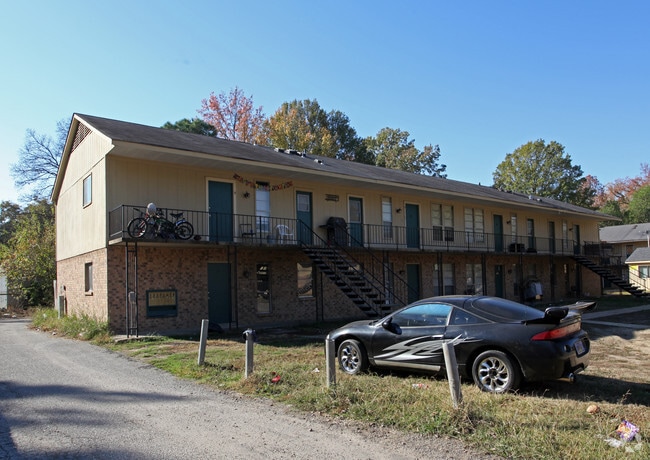
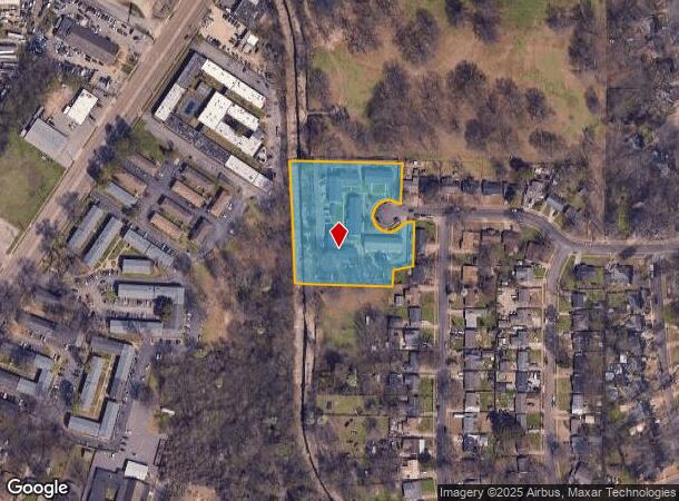
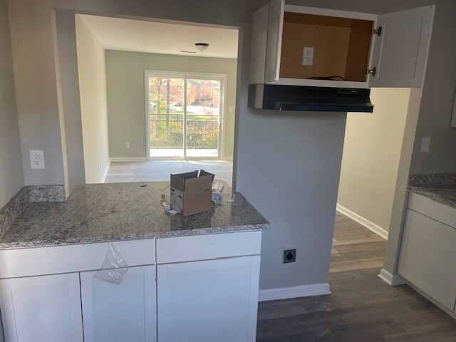
Property Record
3893 Pikes Peak Ave, Memphis, TN 38108

NEARBY LISTINGS FOR SALE OR LEASE
Property Detail
3893 Pikes Peak Ave
Memphis, TN-MS-AR
The Oaks
06-2056-0-0163
SEE MAP B-21
Apartment
Shelby
X
Tennessee
47157C0291G
2
0
2.55 AC
2025
Berclair
011100
Memphis
32,700 SF
DEMOGRAPHICS near 3893 Pikes Peak Ave
1 Mile
3 Mile
5 Mile
2024 Total Population
11,247
72,681
208,701
2029 Population
11,251
72,044
206,615
Pop Growth 2024-2029
+ 0.04%
(0.88%)
(1.00%)
Average Age
33
35
37
2024 Total Households
3,611
27,344
82,812
HH Growth 2024-2029
+ 0.08%
(0.98%)
(1.06%)
Median Household Inc
$39,050
$41,642
$46,924
Avg Household Size
3.00
2.60
2.40
2024 Avg HH Vehicles
2.00
2.00
2.00
Median Home Value
$69,696
$115,691
$178,390
Median Year Built
1955
1959
1964
Nearby Places
- Restaurants
- Banks
- Shops
- Fitness
- Groceries
PUBLIC TRANSPORTATION
AIRPORT
Memphis International
DRIVE
WALK
Distance
Memphis International
21 min
12.7 mi
Freight Ports
Port of Shreveport
DRIVE
WALK
Distance
Port of Shreveport
410 min
376.3 mi
SALE & LEASE HISTORY
LISTING DATE
SALE/LEASE

Feb 23, 2024
For Sale
Nearby Properties
Address
Land Use
TOTAL SIZE
Lot Size
Zoning
Address
Land Use
TOTAL SIZE
Lot Size
Zoning
31,305 SF
17.89 AC
RU-3
Address
Land Use
TOTAL SIZE
Lot Size
Zoning
78,603 SF
23.30 AC
R-6
Address
Land Use
TOTAL SIZE
Lot Size
Zoning
699,184 SF
19.67 AC
IH
Address
Land Use
TOTAL SIZE
Lot Size
Zoning
38,200 SF
22.60 AC
RU-3
Address
Land Use
TOTAL SIZE
Lot Size
Zoning
11,446 SF
29.76 AC
RU-3
Address
Land Use
TOTAL SIZE
Lot Size
Zoning
37,490 SF
4.42 AC
CMU-2
Address
Land Use
TOTAL SIZE
Lot Size
Zoning
55,082 SF
2.31 AC
CMU-1
Address
Land Use
TOTAL SIZE
Lot Size
Zoning
56,983 SF
12.34 AC
RU-3
Address
Land Use
TOTAL SIZE
Lot Size
Zoning
399,662 SF
27.28 AC
EMP
Address
Land Use
TOTAL SIZE
Lot Size
Zoning
35,150 SF
3.59 AC
CMU-3
Address
Land Use
TOTAL SIZE
Lot Size
Zoning
151,958 SF
12.78 AC
CMU-3
Address
Land Use
TOTAL SIZE
Lot Size
Zoning
380,505 SF
30.75 AC
CMU-3
Address
Land Use
TOTAL SIZE
Lot Size
Zoning
68,465 SF
2.24 AC
CMU-3
Address
Land Use
TOTAL SIZE
Lot Size
Zoning
50,447 SF
6.28 AC
R-10
Address
Land Use
TOTAL SIZE
Lot Size
Zoning
26,716 SF
11.37 AC
RU-2
Address
Land Use
TOTAL SIZE
Lot Size
Zoning
54,178 SF
10.24 AC
CMU-3
Address
Land Use
TOTAL SIZE
Lot Size
Zoning
127,456 SF
15.05 AC
EMP
Address
Land Use
TOTAL SIZE
Lot Size
Zoning
99,370 SF
108.70 AC
RU-1
Address
Land Use
TOTAL SIZE
Lot Size
Zoning
212,449 SF
14.07 AC
EMP
Address
Land Use
TOTAL SIZE
Lot Size
Zoning
180,630 SF
21.89 AC
CMU-2
Address
Land Use
TOTAL SIZE
Lot Size
Zoning
58,484 SF
19.95 AC
RU-3
Address
Land Use
TOTAL SIZE
Lot Size
Zoning
136,505 SF
6.76 AC
RU-3
Address
Land Use
TOTAL SIZE
Lot Size
Zoning
27,930 SF
12.14 AC
RU-3
Address
Land Use
TOTAL SIZE
Lot Size
Zoning
26,544 SF
17.63 AC
RU-3
Address
Land Use
TOTAL SIZE
Lot Size
Zoning
101,800 SF
15.97 AC
CMU-2
Address
Land Use
TOTAL SIZE
Lot Size
Zoning
138,738 SF
16 AC
R-6
Address
Land Use
TOTAL SIZE
Lot Size
Zoning
66.90 AC
CMU-2
Address
Land Use
TOTAL SIZE
Lot Size
Zoning
28,512 SF
7 AC
CMU-3
Address
Land Use
TOTAL SIZE
Lot Size
Zoning
74,934 SF
15.37 AC
RU-3
Address
Land Use
TOTAL SIZE
Lot Size
Zoning
54,993 SF
20.39 AC
R-10
The World's #1 Commercial Real Estate Marketplace
Connect with us
© 2025 CoStar Group
The information above has been obtained from sources believed reliable. While we do not doubt its accuracy we have not verified it and make no guarantee, warranty or representation about it. It is your responsibility to independently confirm its accuracy and completeness. Any projections, opinions, assumptions, or estimates used are for example only and do not represent the current or future performance of the property. The value of this transaction to you depends on tax and other factors which should be evaluated by your tax, financial, and legal advisors. You and your advisors should conduct a careful, independent investigation of the property to determine to your satisfaction the suitability of the property for your needs.