Property Record
3895 Se County Road 760A, Arcadia, FL 34266
NEARBY LISTINGS FOR SALE OR LEASE
-
-
View all Arcadia listings for sale on LoopNet.com
Property Detail
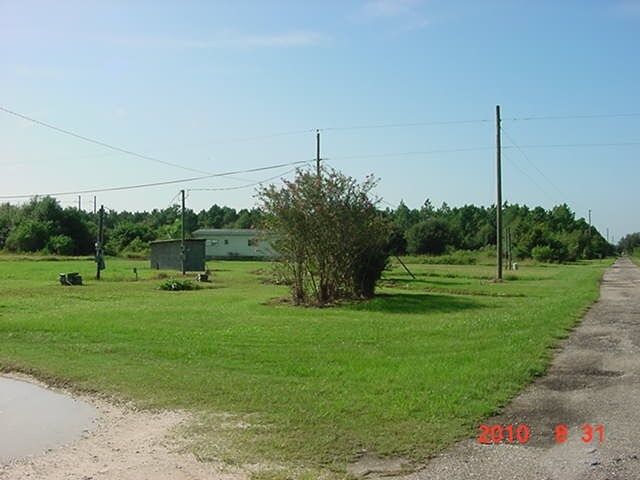
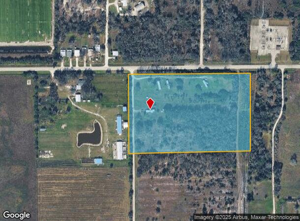
3895 Se County Road 760A
28-38-25-0000-0050-0000
BEG NE COR TH S 1D52M55S E 42.38 FT TO S R/W SR 760A FOR POB TH CONT SAME LI 549.67 FT TH S 87D21M05S W & // TO SAID S R/W 789.295 FT TH N 02D33M 36S W 549.62 FT TO SAID S R/W TH N 87D21M05S E ALG S R/W 795.80 FT TO POB OR 579/1157 OR 584/2575 INST:2
Parkinglot
DeSoto
X
Florida
12027C0189C
10 AC
2022
Florida Central South Area
2024
Other Market Areas
010406
Arcadia, FL
DEMOGRAPHICS near 3895 Se County Road 760A
1 Mile
3 Mile
5 Mile
2024 Total Population
164
2,183
15,018
2029 Population
181
2,355
16,454
Pop Growth 2024-2029
+ 10.37%
+ 7.88%
+ 9.56%
Average Age
40
44
40
2024 Total Households
57
405
4,820
HH Growth 2024-2029
+ 12.28%
+ 11.60%
+ 10.77%
Median Household Inc
$47,500
$54,903
$38,580
Avg Household Size
2.80
2.70
2.80
2024 Avg HH Vehicles
2.00
2.00
2.00
Median Home Value
$207,143
$221,428
$96,620
Median Year Built
1991
1988
1984
Nearby Places
Map Layers
Map Styles
 Street
 Aerial
- Restaurants
- Banks
- Shops
- Fitness
- Groceries
PUBLIC TRANSPORTATION
AIRPORT
Punta Gorda
DRIVE
WALK
Distance
Punta Gorda
40 min
25.1 mi
Freight Ports
Port Manatee
DRIVE
WALK
Distance
Port Manatee
89 min
64.4 mi
Nearby Properties
Address
Land Use
TOTAL SIZE
Lot Size
Zoning
Address
Land Use
TOTAL SIZE
Lot Size
Zoning
56,776 SF
14.75 AC
PUD
Address
Land Use
TOTAL SIZE
Lot Size
Zoning
105,694 SF
28 AC
PUD
Address
Land Use
TOTAL SIZE
Lot Size
Zoning
64,927 SF
41.08 AC
PUD
Address
Land Use
TOTAL SIZE
Lot Size
Zoning
205.86 AC
A-10
Address
Land Use
TOTAL SIZE
Lot Size
Zoning
30,557 SF
86.31 AC
A-10
Address
Land Use
TOTAL SIZE
Lot Size
Zoning
21,003 SF
25.88 AC
PUD
Address
Land Use
TOTAL SIZE
Lot Size
Zoning
3,388 SF
10 AC
MHP
Address
Land Use
TOTAL SIZE
Lot Size
Zoning
5,818 SF
52.32 AC
A-5
Address
Land Use
TOTAL SIZE
Lot Size
Zoning
201,738 SF
29.57 AC
PUD
Address
Land Use
TOTAL SIZE
Lot Size
Zoning
7,307 SF
305.60 AC
A-5
Address
Land Use
TOTAL SIZE
Lot Size
Zoning
57,305 SF
11.74 AC
PUD
Address
Land Use
TOTAL SIZE
Lot Size
Zoning
6,568 SF
10 AC
A-5
Address
Land Use
TOTAL SIZE
Lot Size
Zoning
25,804 SF
347.75 AC
PUD
Address
Land Use
TOTAL SIZE
Lot Size
Zoning
224.21 AC
A-10
Address
Land Use
TOTAL SIZE
Lot Size
Zoning
6,410 SF
21 AC
A-5
Address
Land Use
TOTAL SIZE
Lot Size
Zoning
4,047 SF
17.36 AC
A-5
Address
Land Use
TOTAL SIZE
Lot Size
Zoning
7,447 SF
15 AC
A-5
Address
Land Use
TOTAL SIZE
Lot Size
Zoning
90 AC
A-10
Address
Land Use
TOTAL SIZE
Lot Size
Zoning
62.26 AC
IL
Address
Land Use
TOTAL SIZE
Lot Size
Zoning
5,940 SF
1.25 AC
RSF-3
Address
Land Use
TOTAL SIZE
Lot Size
Zoning
13,642 SF
124.26 AC
A-5
Address
Land Use
TOTAL SIZE
Lot Size
Zoning
22.88 AC
RSF-2
Address
Land Use
TOTAL SIZE
Lot Size
Zoning
5,329 SF
15.27 AC
A-5
Address
Land Use
TOTAL SIZE
Lot Size
Zoning
3,720 SF
148.02 AC
A-5
Address
Land Use
TOTAL SIZE
Lot Size
Zoning
58,263 SF
5.29 AC
PUD
Address
Land Use
TOTAL SIZE
Lot Size
Zoning
3,736 SF
39.50 AC
A-10
Address
Land Use
TOTAL SIZE
Lot Size
Zoning
5,214 SF
25.05 AC
A-5
Address
Land Use
TOTAL SIZE
Lot Size
Zoning
8,891 SF
25.50 AC
A-5
Address
Land Use
TOTAL SIZE
Lot Size
Zoning
640 AC
A-10
Address
Land Use
TOTAL SIZE
Lot Size
Zoning
14 AC
PUD
The World's #1 Commercial Real Estate Marketplace
Connect with us
© 2025 CoStar Group
The information above has been obtained from sources believed reliable. While we do not doubt its accuracy we have not verified it and make no guarantee, warranty or representation about it. It is your responsibility to independently confirm its accuracy and completeness. Any projections, opinions, assumptions, or estimates used are for example only and do not represent the current or future performance of the property. The value of this transaction to you depends on tax and other factors which should be evaluated by your tax, financial, and legal advisors. You and your advisors should conduct a careful, independent investigation of the property to determine to your satisfaction the suitability of the property for your needs.