Property Record
38Th St, Kenosha, WI 53142

Save to a Folder
{{folder.Name}}
{{folder.ListingIds.length}} Properties
{{folder.ListingIds.length}} Property
Create a New Folder
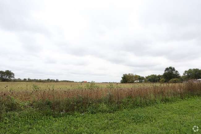
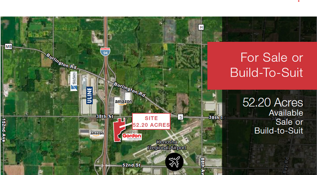
This Property Is For Sale
Property Detail
38Th St
Kenosha, WI
LOT 2 CSM # 2639 AS SHOWN ON PAGE 3 OF CSM DOC#1567236 PT OF S 1/2 SEC 30 T 2 R 22 52.2 AC (2009 PT 08-222-30-301-010) DOC#15
08-222-30-301-002
KENOSHA
Agriculturalland
Wisconsin
FW
2
AE The base floodplain where base flood elevations are provided. AE Zones are now used on new format FIRMs instead of A1-A30 Zones.
52.20 AC
2025
Kenosha East
2025
Chicago
002500
NEARBY LISTINGS FOR SALE OR LEASE
DEMOGRAPHICS near 38Th St
1 mile
3 mile
5 mile
2025 Total Population
155
11,359
46,817
2030 Population
154
11,345
46,893
Pop Growth 2025-2030
(0.65%)
(0.12%)
+ 0.16%
Average Age
43
39
40
2025 Total Households
72
4,028
17,986
HH Growth 2025-2030
0.00%
(0.10%)
+ 0.13%
Median Household Inc
$60,750
$107,854
$89,805
Avg Household Size
2.10
2.70
2.50
2025 Avg HH Vehicles
2.00
2.00
2.00
Median Home Value
$271,428
$330,776
$285,378
Median Year Built
2002
1997
1990
Nearby Places
Map Layers
Map Styles
 Street
 Aerial
Layers
 Traffic
 Biking
Places
Listings with unknown addresses are not visible on the map
- Restaurants
- Banks
- Shops
- Fitness
- Groceries
PUBLIC TRANSPORTATION
COMMUTER RAIL
Kenosha (Union Pacific North - Metra)
Drive
Walk
Distance
Kenosha (Union Pacific North - Metra)
17 min
7.6 mi
Sturtevant Amtrak Station (Borealis - Amtrak, Hiawatha Service - Amtrak)
Drive
Walk
Distance
Sturtevant Amtrak Station (Borealis - Amtrak, Hiawatha Service - Amtrak)
19 min
10.0 mi
AIRPORT
General Mitchell International
Drive
Walk
Distance
General Mitchell International
35 min
26.7 mi
Freight Ports
Port Milwaukee
Drive
Walk
Distance
Port Milwaukee
40 min
30.6 mi
Nearby Properties
Address
Land Use
TOTAL SIZE
Lot Size
Zoning
Address
Land Use
TOTAL SIZE
Lot Size
Zoning
1,082,250 SF
58.93 AC
M2
Address
Land Use
TOTAL SIZE
Lot Size
Zoning
1,015,740 SF
113.58 AC
C2
Address
Land Use
TOTAL SIZE
Lot Size
Zoning
880,696 SF
68.19 AC
M2
Address
Land Use
TOTAL SIZE
Lot Size
Zoning
731,186 SF
81.94 AC
M2
Address
Land Use
TOTAL SIZE
Lot Size
Zoning
800,000 SF
48.22 AC
M2
Address
Land Use
TOTAL SIZE
Lot Size
Zoning
646,208 SF
44.09 AC
C2
Address
Land Use
TOTAL SIZE
Lot Size
Zoning
918,624 SF
65.18 AC
Address
Land Use
TOTAL SIZE
Lot Size
Zoning
481,854 SF
84.10 AC
FW
Address
Land Use
TOTAL SIZE
Lot Size
Zoning
20,257 SF
16.01 AC
Address
Land Use
TOTAL SIZE
Lot Size
Zoning
748,800 SF
67.63 AC
FW
Address
Land Use
TOTAL SIZE
Lot Size
Zoning
12,876 SF
30.13 AC
Address
Land Use
TOTAL SIZE
Lot Size
Zoning
1,467 SF
50.67 AC
M2
Address
Land Use
TOTAL SIZE
Lot Size
Zoning
77.22 AC
M2
Address
Land Use
TOTAL SIZE
Lot Size
Zoning
513,760 SF
48.61 AC
C1
Address
Land Use
TOTAL SIZE
Lot Size
Zoning
795,475 SF
49.72 AC
Address
Land Use
TOTAL SIZE
Lot Size
Zoning
850,230 SF
39.46 AC
M2
Address
Land Use
TOTAL SIZE
Lot Size
Zoning
763,999 SF
57.67 AC
FW
Address
Land Use
TOTAL SIZE
Lot Size
Zoning
734,761 SF
43.56 AC
Address
Land Use
TOTAL SIZE
Lot Size
Zoning
626,520 SF
35.19 AC
M2
Address
Land Use
TOTAL SIZE
Lot Size
Zoning
25,633 SF
13.10 AC
Address
Land Use
TOTAL SIZE
Lot Size
Zoning
31,809 SF
11.36 AC
BASE
Address
Land Use
TOTAL SIZE
Lot Size
Zoning
525,048 SF
35.73 AC
M2
Address
Land Use
TOTAL SIZE
Lot Size
Zoning
602,348 SF
36.02 AC
Address
Land Use
TOTAL SIZE
Lot Size
Zoning
601,439 SF
32.10 AC
Address
Land Use
TOTAL SIZE
Lot Size
Zoning
3,721 SF
24.57 AC
FW
Address
Land Use
TOTAL SIZE
Lot Size
Zoning
32,526 SF
47.82 AC
Address
Land Use
TOTAL SIZE
Lot Size
Zoning
509,017 SF
34.37 AC
Address
Land Use
TOTAL SIZE
Lot Size
Zoning
205,894 SF
31.07 AC
M2
Address
Land Use
TOTAL SIZE
Lot Size
Zoning
376,320 SF
35.18 AC
M2
Address
Land Use
TOTAL SIZE
Lot Size
Zoning
52,016 SF
25.40 AC
FW
The World's #1 Commercial Real Estate Marketplace
Connect with us
© 2026 CoStar Group
The information above has been obtained from sources believed reliable. While we do not doubt its accuracy we have not verified it and make no guarantee, warranty or representation about it. It is your responsibility to independently confirm its accuracy and completeness. Any projections, opinions, assumptions, or estimates used are for example only and do not represent the current or future performance of the property. The value of this transaction to you depends on tax and other factors which should be evaluated by your tax, financial, and legal advisors. You and your advisors should conduct a careful, independent investigation of the property to determine to your satisfaction the suitability of the property for your needs.