Property Record
39 E 39Th St, Paterson, NJ 07514
This Property Is For Sale
NEARBY LISTINGS FOR SALE OR LEASE
Property Detail
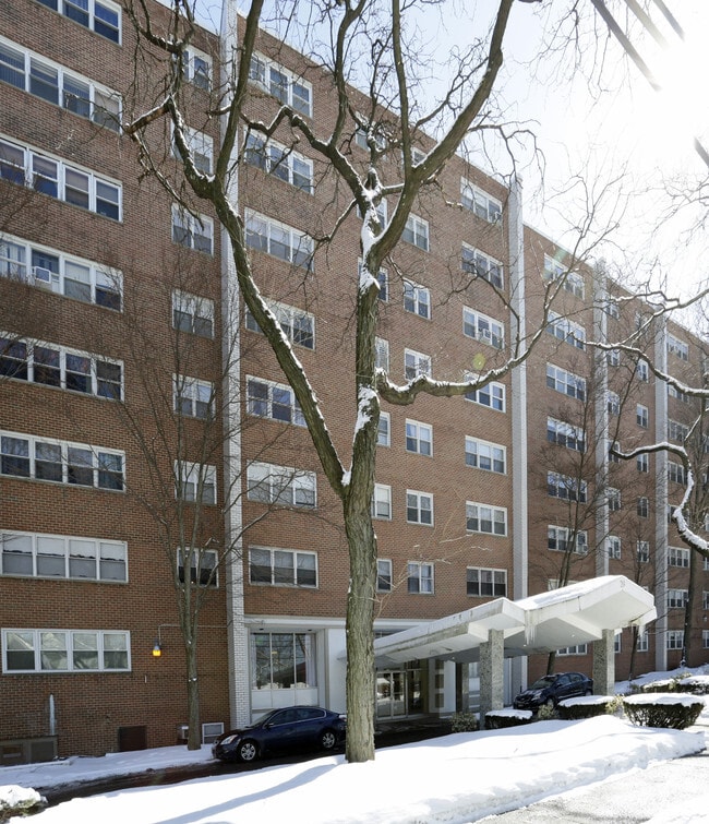
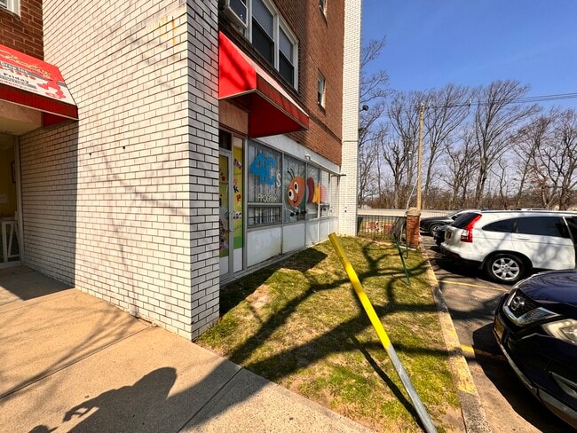
39 E 39Th St
New York-Jersey City-White Plains, NY-NJ
Empress House
08-08205-0000-00010-0000-C1002
FACILITY NAME: SMALL OFFICE
Officecondo
Passaic
X
New Jersey
34031C0217G
10
2024
0.01 AC
2025
Eastside
182502
Northern New Jersey
800 SF
DEMOGRAPHICS near 39 E 39Th St
1 Mile
3 Mile
5 Mile
2024 Total Population
40,822
261,287
587,922
2029 Population
39,728
251,687
571,978
Pop Growth 2024-2029
(2.68%)
(3.67%)
(2.71%)
Average Age
39
38
39
2024 Total Households
13,274
86,753
200,361
HH Growth 2024-2029
(2.73%)
(3.76%)
(2.78%)
Median Household Inc
$67,241
$67,963
$77,020
Avg Household Size
2.90
2.90
2.80
2024 Avg HH Vehicles
2.00
2.00
2.00
Median Home Value
$395,950
$416,078
$455,059
Median Year Built
1949
1952
1954
Nearby Places
Map Layers
Map Styles
 Street
 Aerial
- Restaurants
- Banks
- Shops
- Fitness
- Groceries
PUBLIC TRANSPORTATION
COMMUTER RAIL
Broadway (Bergen County/Port Jervis Line - NJ Transit Commuter Rail (NJ Transit))
DRIVE
WALK
Distance
Broadway (Bergen County/Port Jervis Line - NJ Transit Commuter Rail (NJ Transit))
4 min
1.8 mi
Radburn (Bergen County/Port Jervis Line - NJ Transit Commuter Rail (NJ Transit))
DRIVE
WALK
Distance
Radburn (Bergen County/Port Jervis Line - NJ Transit Commuter Rail (NJ Transit))
6 min
3.1 mi
AIRPORT
Newark Liberty International
DRIVE
WALK
Distance
Newark Liberty International
25 min
20.5 mi
LaGuardia
DRIVE
WALK
Distance
LaGuardia
36 min
22.9 mi
Westchester County
DRIVE
WALK
Distance
Westchester County
56 min
38.7 mi
Freight Ports
Port Newark Container Terminal
DRIVE
WALK
Distance
Port Newark Container Terminal
29 min
19.7 mi
Nearby Properties
Address
Land Use
TOTAL SIZE
Lot Size
Zoning
Address
Land Use
TOTAL SIZE
Lot Size
Zoning
8.75 AC
Address
Land Use
TOTAL SIZE
Lot Size
Zoning
12,506 SF
130 AC
B-2
Address
Land Use
TOTAL SIZE
Lot Size
Zoning
7,060 SF
115.84 AC
HP
Address
Land Use
TOTAL SIZE
Lot Size
Zoning
8.66 AC
CH1
Address
Land Use
TOTAL SIZE
Lot Size
Zoning
12,268 SF
98 AC
CR
Address
Land Use
TOTAL SIZE
Lot Size
Zoning
79,310 SF
2 AC
B-2
Address
Land Use
TOTAL SIZE
Lot Size
Zoning
25.50 AC
B2
Address
Land Use
TOTAL SIZE
Lot Size
Zoning
26,816 SF
25.50 AC
POP
Address
Land Use
TOTAL SIZE
Lot Size
Zoning
242,048 SF
25.40 AC
BLL
Address
Land Use
TOTAL SIZE
Lot Size
Zoning
9.96 AC
MU
Address
Land Use
TOTAL SIZE
Lot Size
Zoning
Address
Land Use
TOTAL SIZE
Lot Size
Zoning
152,050 SF
1.96 AC
B-1
Address
Land Use
TOTAL SIZE
Lot Size
Zoning
57,680 SF
20.01 AC
CR
Address
Land Use
TOTAL SIZE
Lot Size
Zoning
7.83 AC
Address
Land Use
TOTAL SIZE
Lot Size
Zoning
5.40 AC
RB
Address
Land Use
TOTAL SIZE
Lot Size
Zoning
Address
Land Use
TOTAL SIZE
Lot Size
Zoning
116,670 SF
13.79 AC
BIL
Address
Land Use
TOTAL SIZE
Lot Size
Zoning
1.80 AC
Address
Land Use
TOTAL SIZE
Lot Size
Zoning
0.69 AC
I-1
Address
Land Use
TOTAL SIZE
Lot Size
Zoning
824,024 SF
39.71 AC
I1
Address
Land Use
TOTAL SIZE
Lot Size
Zoning
1,512 SF
90 AC
Address
Land Use
TOTAL SIZE
Lot Size
Zoning
90.48 AC
Address
Land Use
TOTAL SIZE
Lot Size
Zoning
Address
Land Use
TOTAL SIZE
Lot Size
Zoning
5.88 AC
Address
Land Use
TOTAL SIZE
Lot Size
Zoning
59.45 AC
R100
Address
Land Use
TOTAL SIZE
Lot Size
Zoning
27.25 AC
Address
Land Use
TOTAL SIZE
Lot Size
Zoning
6.66 AC
RM
Address
Land Use
TOTAL SIZE
Lot Size
Zoning
0.01 AC
Address
Land Use
TOTAL SIZE
Lot Size
Zoning
16.05 AC
Address
Land Use
TOTAL SIZE
Lot Size
Zoning
The World's #1 Commercial Real Estate Marketplace
Connect with us
© 2026 CoStar Group
The information above has been obtained from sources believed reliable. While we do not doubt its accuracy we have not verified it and make no guarantee, warranty or representation about it. It is your responsibility to independently confirm its accuracy and completeness. Any projections, opinions, assumptions, or estimates used are for example only and do not represent the current or future performance of the property. The value of this transaction to you depends on tax and other factors which should be evaluated by your tax, financial, and legal advisors. You and your advisors should conduct a careful, independent investigation of the property to determine to your satisfaction the suitability of the property for your needs.