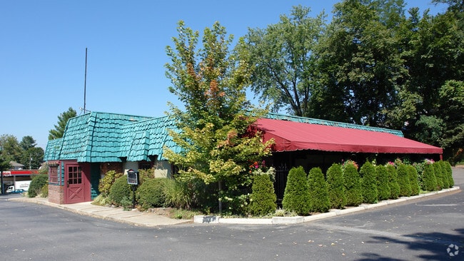
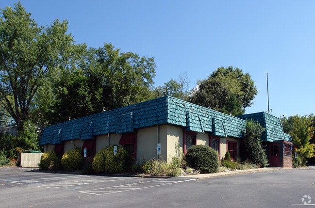
Property Record
39 Elm St, Asheville, NC 28801


NEARBY LISTINGS FOR SALE OR LEASE
Property Detail
39 Elm St
9649-42-1474-00000
Je Rankin Estate
Hotel
SUBDIV: BLOCK: LOT: SECTION: PLAT: 0190-0048
X
Buncombe
3700964900J
North Carolina
2024
0.90 AC
2025
North Asheville
000600
Asheville
14,252 SF
Asheville, NC
DEMOGRAPHICS near 39 Elm St
1 Mile
3 Mile
5 Mile
2024 Total Population
12,025
54,575
100,453
2029 Population
12,539
56,594
104,047
Pop Growth 2024-2029
+ 4.27%
+ 3.70%
+ 3.58%
Average Age
41
41
42
2024 Total Households
5,788
24,819
44,929
HH Growth 2024-2029
+ 4.06%
+ 3.28%
+ 3.10%
Median Household Inc
$55,238
$62,458
$63,239
Avg Household Size
1.80
2.00
2.10
2024 Avg HH Vehicles
1.00
2.00
2.00
Median Home Value
$485,319
$408,479
$368,459
Median Year Built
1956
1970
1976
Nearby Places
Map Layers
Map Styles
 Street
 Aerial
- Restaurants
- Banks
- Shops
- Fitness
- Groceries
PUBLIC TRANSPORTATION
AIRPORT
Asheville Regional
DRIVE
WALK
Distance
Asheville Regional
21 min
14.9 mi
Nearby Properties
Address
Land Use
TOTAL SIZE
Lot Size
Zoning
Address
Land Use
TOTAL SIZE
Lot Size
Zoning
1,663,129 SF
27.85 AC
INST
Address
Land Use
TOTAL SIZE
Lot Size
Zoning
358,342 SF
137.57 AC
RESORT
Address
Land Use
TOTAL SIZE
Lot Size
Zoning
291,240 SF
86.10 AC
INST EXP
Address
Land Use
TOTAL SIZE
Lot Size
Zoning
496,200 SF
109.28 AC
INST
Address
Land Use
TOTAL SIZE
Lot Size
Zoning
40,152 SF
2.78 AC
CBD
Address
Land Use
TOTAL SIZE
Lot Size
Zoning
31,034 SF
1.12 AC
CBD
Address
Land Use
TOTAL SIZE
Lot Size
Zoning
94,776 SF
39.70 AC
INST
Address
Land Use
TOTAL SIZE
Lot Size
Zoning
94,004 SF
2.74 AC
CBD
Address
Land Use
TOTAL SIZE
Lot Size
Zoning
109,294 SF
16.28 AC
RAD-IND
Address
Land Use
TOTAL SIZE
Lot Size
Zoning
118,000 SF
0.17 AC
CBD
Address
Land Use
TOTAL SIZE
Lot Size
Zoning
125,122 SF
13.63 AC
UP
Address
Land Use
TOTAL SIZE
Lot Size
Zoning
47,344 SF
0.71 AC
CBD
Address
Land Use
TOTAL SIZE
Lot Size
Zoning
170,226 SF
29.47 AC
INST
Address
Land Use
TOTAL SIZE
Lot Size
Zoning
51,476 SF
5.82 AC
CBD
Address
Land Use
TOTAL SIZE
Lot Size
Zoning
78,563 SF
2.88 AC
UP
Address
Land Use
TOTAL SIZE
Lot Size
Zoning
20,352 SF
0.67 AC
CBD
Address
Land Use
TOTAL SIZE
Lot Size
Zoning
426,688 SF
40.88 AC
UP
Address
Land Use
TOTAL SIZE
Lot Size
Zoning
50,248 SF
12.87 AC
INST
Address
Land Use
TOTAL SIZE
Lot Size
Zoning
47,729 SF
5.50 AC
CBD
Address
Land Use
TOTAL SIZE
Lot Size
Zoning
75,342 SF
8.07 AC
HB
Address
Land Use
TOTAL SIZE
Lot Size
Zoning
52,336 SF
2.05 AC
CBD
Address
Land Use
TOTAL SIZE
Lot Size
Zoning
40,900 SF
13.77 AC
R-5
Address
Land Use
TOTAL SIZE
Lot Size
Zoning
59,200 SF
33.49 AC
R-1
Address
Land Use
TOTAL SIZE
Lot Size
Zoning
18,444 SF
0.66 AC
CBD
Address
Land Use
TOTAL SIZE
Lot Size
Zoning
69,472 SF
0.99 AC
CBD
Address
Land Use
TOTAL SIZE
Lot Size
Zoning
30,000 SF
8.25 AC
INST
Address
Land Use
TOTAL SIZE
Lot Size
Zoning
114,700 SF
8.91 AC
RM16
Address
Land Use
TOTAL SIZE
Lot Size
Zoning
80,319 SF
CBD
Address
Land Use
TOTAL SIZE
Lot Size
Zoning
71,241 SF
7.75 AC
HB
Address
Land Use
TOTAL SIZE
Lot Size
Zoning
53,842 SF
8.08 AC
RM16
The World's #1 Commercial Real Estate Marketplace
Connect with us
© 2026 CoStar Group
The information above has been obtained from sources believed reliable. While we do not doubt its accuracy we have not verified it and make no guarantee, warranty or representation about it. It is your responsibility to independently confirm its accuracy and completeness. Any projections, opinions, assumptions, or estimates used are for example only and do not represent the current or future performance of the property. The value of this transaction to you depends on tax and other factors which should be evaluated by your tax, financial, and legal advisors. You and your advisors should conduct a careful, independent investigation of the property to determine to your satisfaction the suitability of the property for your needs.