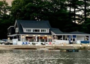
Property Record
39 Elm St, Dracut, MA 01826
NEARBY LISTINGS FOR SALE OR LEASE
Property Detail
39 Elm St
Restaurantbuilding
Middlesex
A
Massachusetts
25017C0128F
0.22 AC
2025
Groton/Townsend
2025
Boston
313102
Boston-Cambridge-Newton, MA-NH
3,750 SF
DRAC-000014-000000-000012
DEMOGRAPHICS near 39 Elm St
1 Mile
3 Mile
5 Mile
2024 Total Population
6,394
32,879
150,482
2029 Population
6,339
32,687
149,038
Pop Growth 2024-2029
(0.86%)
(0.58%)
(0.96%)
Average Age
41
42
39
2024 Total Households
2,226
12,183
56,055
HH Growth 2024-2029
(0.99%)
(0.71%)
(0.92%)
Median Household Inc
$110,504
$100,253
$81,198
Avg Household Size
2.80
2.60
2.50
2024 Avg HH Vehicles
2.00
2.00
2.00
Median Home Value
$458,032
$416,658
$392,958
Median Year Built
1981
1982
1970
Nearby Places
Map Layers
Map Styles
 Street
 Aerial
- Restaurants
- Banks
- Shops
- Fitness
- Groceries
PUBLIC TRANSPORTATION
COMMUTER RAIL
Lowell (Lowell Line - Massachusetts Bay Transportation Authority Commuter Rail (Purple Line))
DRIVE
WALK
Distance
Lowell (Lowell Line - Massachusetts Bay Transportation Authority Commuter Rail (Purple Line))
12 min
5.5 mi
North Billerica (Lowell Line - Massachusetts Bay Transportation Authority Commuter Rail (Purple Line))
DRIVE
WALK
Distance
North Billerica (Lowell Line - Massachusetts Bay Transportation Authority Commuter Rail (Purple Line))
21 min
9.8 mi
AIRPORT
Manchester Boston Regional
DRIVE
WALK
Distance
Manchester Boston Regional
39 min
23.8 mi
General Edward Lawrence Logan International
DRIVE
WALK
Distance
General Edward Lawrence Logan International
56 min
35.7 mi
Freight Ports
Port of Boston
DRIVE
WALK
Distance
Port of Boston
57 min
35.5 mi
Nearby Properties
Address
Land Use
TOTAL SIZE
Lot Size
Zoning
Address
Land Use
TOTAL SIZE
Lot Size
Zoning
70.20 AC
R3
Address
Land Use
TOTAL SIZE
Lot Size
Zoning
68.15 AC
R1
Address
Land Use
TOTAL SIZE
Lot Size
Zoning
33.01 AC
R3
Address
Land Use
TOTAL SIZE
Lot Size
Zoning
45.10 AC
R1
Address
Land Use
TOTAL SIZE
Lot Size
Zoning
8.30 AC
B3
Address
Land Use
TOTAL SIZE
Lot Size
Zoning
177.27 AC
R1
Address
Land Use
TOTAL SIZE
Lot Size
Zoning
4.33 AC
R3
Address
Land Use
TOTAL SIZE
Lot Size
Zoning
15.86 AC
B3
Address
Land Use
TOTAL SIZE
Lot Size
Zoning
4.88 AC
R1
Address
Land Use
TOTAL SIZE
Lot Size
Zoning
3.77 AC
B3
Address
Land Use
TOTAL SIZE
Lot Size
Zoning
8.30 AC
R1
Address
Land Use
TOTAL SIZE
Lot Size
Zoning
17.86 AC
I1
Address
Land Use
TOTAL SIZE
Lot Size
Zoning
63,138 SF
0.68 AC
I1
Address
Land Use
TOTAL SIZE
Lot Size
Zoning
11,434 SF
4.81 AC
R3
Address
Land Use
TOTAL SIZE
Lot Size
Zoning
4.82 AC
R3
Address
Land Use
TOTAL SIZE
Lot Size
Zoning
2,904 SF
15 AC
R3
Address
Land Use
TOTAL SIZE
Lot Size
Zoning
2.59 AC
I1
Address
Land Use
TOTAL SIZE
Lot Size
Zoning
5.03 AC
B2
Address
Land Use
TOTAL SIZE
Lot Size
Zoning
6.88 AC
B1
Address
Land Use
TOTAL SIZE
Lot Size
Zoning
13,376 SF
12.37 AC
R2
Address
Land Use
TOTAL SIZE
Lot Size
Zoning
80,140 SF
2.30 AC
B3
Address
Land Use
TOTAL SIZE
Lot Size
Zoning
92,440 SF
B3
Address
Land Use
TOTAL SIZE
Lot Size
Zoning
83,417 SF
10.30 AC
G1
Address
Land Use
TOTAL SIZE
Lot Size
Zoning
177.88 AC
R1
Address
Land Use
TOTAL SIZE
Lot Size
Zoning
4.91 AC
B1
Address
Land Use
TOTAL SIZE
Lot Size
Zoning
100,572 SF
17.70 AC
I1
Address
Land Use
TOTAL SIZE
Lot Size
Zoning
36,000 SF
12.25 AC
G1
Address
Land Use
TOTAL SIZE
Lot Size
Zoning
98,118 SF
9.20 AC
B3
Address
Land Use
TOTAL SIZE
Lot Size
Zoning
7.77 AC
R1
Address
Land Use
TOTAL SIZE
Lot Size
Zoning
80,500 SF
I1
The World's #1 Commercial Real Estate Marketplace
Connect with us
© 2026 CoStar Group
The information above has been obtained from sources believed reliable. While we do not doubt its accuracy we have not verified it and make no guarantee, warranty or representation about it. It is your responsibility to independently confirm its accuracy and completeness. Any projections, opinions, assumptions, or estimates used are for example only and do not represent the current or future performance of the property. The value of this transaction to you depends on tax and other factors which should be evaluated by your tax, financial, and legal advisors. You and your advisors should conduct a careful, independent investigation of the property to determine to your satisfaction the suitability of the property for your needs.