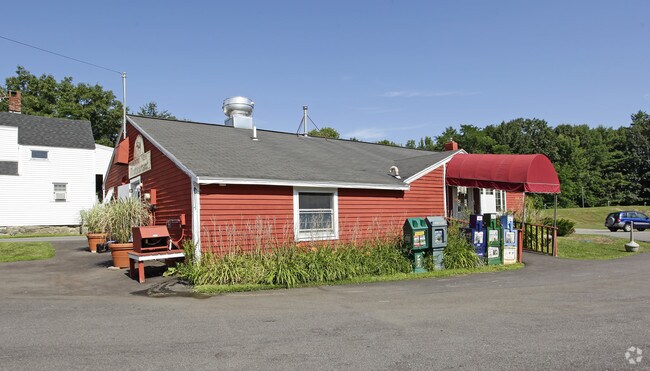
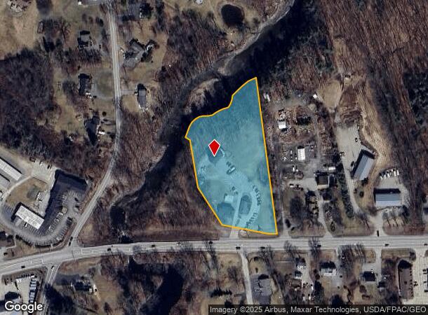
Property Record
39 Kelsey Way, Greenland, NH 03840
NEARBY LISTINGS FOR SALE OR LEASE
Property Detail
39 Kelsey Way
GRNL M:R B:17 L:61
Rockingham
Commercialnec
New Hampshire
X
61
33015C0265F
2 AC
2024
Rockingham
2024
Boston
107500
Boston-Cambridge-Newton, MA-NH
1,538 SF
DEMOGRAPHICS near 39 Kelsey Way
1 Mile
3 Mile
5 Mile
2024 Total Population
1,552
10,642
38,951
2029 Population
1,618
11,050
40,590
Pop Growth 2024-2029
+ 4.25%
+ 3.83%
+ 4.21%
Average Age
44
44
44
2024 Total Households
603
4,253
16,627
HH Growth 2024-2029
+ 4.15%
+ 3.74%
+ 4.18%
Median Household Inc
$129,281
$126,356
$112,034
Avg Household Size
2.60
2.50
2.30
2024 Avg HH Vehicles
2.00
2.00
2.00
Median Home Value
$619,531
$580,121
$602,383
Median Year Built
1988
1985
1979
Nearby Places
Map Layers
Map Styles
 Street
 Aerial
- Restaurants
- Banks
- Shops
- Fitness
- Groceries
PUBLIC TRANSPORTATION
COMMUTER RAIL
DRIVE
WALK
Distance
19 min
8.8 mi
AIRPORT
Portsmouth International at Pease
DRIVE
WALK
Distance
Portsmouth International at Pease
12 min
5.3 mi
Manchester Boston Regional
DRIVE
WALK
Distance
Manchester Boston Regional
60 min
41.0 mi
Freight Ports
Portland, ME
DRIVE
WALK
Distance
Portland, ME
69 min
56.5 mi
Nearby Properties
Address
Land Use
TOTAL SIZE
Lot Size
Zoning
Address
Land Use
TOTAL SIZE
Lot Size
Zoning
28.05 AC
GA/MH
Address
Land Use
TOTAL SIZE
Lot Size
Zoning
33.39 AC
IND
Address
Land Use
TOTAL SIZE
Lot Size
Zoning
87,917 SF
29.26 AC
RA
Address
Land Use
TOTAL SIZE
Lot Size
Zoning
85,152 SF
13.04 AC
G1
Address
Land Use
TOTAL SIZE
Lot Size
Zoning
108,116 SF
18.48 AC
IND
Address
Land Use
TOTAL SIZE
Lot Size
Zoning
207,279 SF
33.07 AC
I
Address
Land Use
TOTAL SIZE
Lot Size
Zoning
132,784 SF
22.32 AC
IND
Address
Land Use
TOTAL SIZE
Lot Size
Zoning
107,657 SF
8.67 AC
IND
Address
Land Use
TOTAL SIZE
Lot Size
Zoning
1,740 SF
67.09 AC
GA/MH
Address
Land Use
TOTAL SIZE
Lot Size
Zoning
3.80 AC
G1
Address
Land Use
TOTAL SIZE
Lot Size
Zoning
4.79 AC
I
Address
Land Use
TOTAL SIZE
Lot Size
Zoning
83,021 SF
3.54 AC
RES
Address
Land Use
TOTAL SIZE
Lot Size
Zoning
34,359 SF
10.15 AC
COM
Address
Land Use
TOTAL SIZE
Lot Size
Zoning
7,350 SF
100 AC
NRP
Address
Land Use
TOTAL SIZE
Lot Size
Zoning
62,322 SF
5.55 AC
I
Address
Land Use
TOTAL SIZE
Lot Size
Zoning
3.51 AC
G1
Address
Land Use
TOTAL SIZE
Lot Size
Zoning
7.44 AC
I
Address
Land Use
TOTAL SIZE
Lot Size
Zoning
1.94 AC
G1
Address
Land Use
TOTAL SIZE
Lot Size
Zoning
96,178 SF
8.44 AC
I
Address
Land Use
TOTAL SIZE
Lot Size
Zoning
23.30 AC
IND
Address
Land Use
TOTAL SIZE
Lot Size
Zoning
77,451 SF
8.57 AC
I
Address
Land Use
TOTAL SIZE
Lot Size
Zoning
20 AC
RES
Address
Land Use
TOTAL SIZE
Lot Size
Zoning
33,537 SF
6.55 AC
AI
Address
Land Use
TOTAL SIZE
Lot Size
Zoning
252 AC
RES
Address
Land Use
TOTAL SIZE
Lot Size
Zoning
28.02 AC
IND
Address
Land Use
TOTAL SIZE
Lot Size
Zoning
75,944 SF
14.40 AC
I
Address
Land Use
TOTAL SIZE
Lot Size
Zoning
972 SF
35.99 AC
RES
Address
Land Use
TOTAL SIZE
Lot Size
Zoning
27,788 SF
7.41 AC
COM
Address
Land Use
TOTAL SIZE
Lot Size
Zoning
15,056 SF
3.18 AC
M
Address
Land Use
TOTAL SIZE
Lot Size
Zoning
151.90 AC
RES
The World's #1 Commercial Real Estate Marketplace
Connect with us
© 2025 CoStar Group
The information above has been obtained from sources believed reliable. While we do not doubt its accuracy we have not verified it and make no guarantee, warranty or representation about it. It is your responsibility to independently confirm its accuracy and completeness. Any projections, opinions, assumptions, or estimates used are for example only and do not represent the current or future performance of the property. The value of this transaction to you depends on tax and other factors which should be evaluated by your tax, financial, and legal advisors. You and your advisors should conduct a careful, independent investigation of the property to determine to your satisfaction the suitability of the property for your needs.